ap

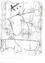
 at last. first is map carved on a small flat rock with the date 1632 on the back side with a small arrow pointing to a rockhouse about 1/2 mile away up this small drain.
inside the rockhouse is where a cryptic map was once, but lucky that a man had sent me this photo of the carving before it was removed from the wall. remember almost all carvings back than had to do with the land around the carvings.
at last. first is map carved on a small flat rock with the date 1632 on the back side with a small arrow pointing to a rockhouse about 1/2 mile away up this small drain. inside the rockhouse is where a cryptic map was once, but lucky that a man had sent me this photo of the carving before it was removed from the wall. remember almost all carvings back than had to do with the land around the carvings.
Amazon Forum Fav 👍


Attachments
Last edited:
