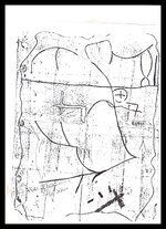
I w ould have sent the info sooner but to many storms and 3 miles of elect. lines replaced. since my treasure hunting days or done for, I have a bunch of stuff I have found, while out researching. I will pass them on. this map is true has to location and hidden areas. part 1 is has part of the map shows. turkey foot ky. on war fork of station camp creek below Irvine ky. about 10 miles. I did not go in the caves next to the road because to many kids on 4 wheelers. look at the 1632 map it will show a cross and next to it 3 lines that look like boxes or coffins those 3 lines or caves. 2 point toward the north the other points toward the east just around the ridge. just like the map. the cross had me stumped for a little while until I went up around on the ridge and found that it had 3 prongs and there was a small rock with 3 lines pointing south, one was off by it self and the word phllpa or ehllpa not sure. check those caves closely, the walls, floors they may connect with each other and they may go a long way. stay safe and walk slow, the Spanish are vary smart at hiding sites.

Attachments
Last edited: