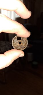
I was going to give you all, the info in one large map, but I have to do it in sections. Paul Henson gave me info on the silver mine hollow in Jackson county. looking at the place (wow) it was dug-up like lower devils creek. At the mouth of the hollow I did find a carving that was vary old with a line carved down the center. the carving was shaped like a triangle with one point showing north along with the line down the center. if you notice there is no triangle on the Spanish map. later on I found out why. the two lower points of the triangle ran east and west.
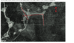
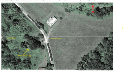
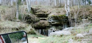
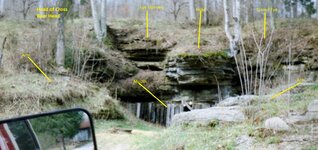
the maps below will show how it worked out. the large cross on the Spanish map is a small valley running east and west with a sharp turn on the east end heading south. there are two drains on the west end of the cross heading north and south with the south arm short and the north arm long. between the two arms is a large lime stone rock that was cut in the shape of a bear with the arms out stretched and the mouth opened. I noticed the head faced down the valley and it was looking dew east. look at the photo of the bear and you will see that one eye is closed. I found that the eye had been chipped away with only one eye pointing east. I know that a vary old Indian group must have done it because in the mornings the rising sun would show in the mouth of the small opening. some one later on chipped the eye shut. two make a pointer to something else? the lady that owned the place said I could look at it all I wanted. but that was back in 2003. I donot know who has the place now, but a contract would help because there may be something buried inside the mouth? or at the end of the valley, also check each end of the arms.
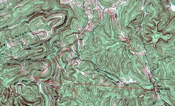
the map showing the triangle in red also shows an arrow center bottom. showing a hill that the line runs though, vary near the center of the hill are carvings. east end of lower line is wind cave, you will see a small ledge on east side that has a small turkey track pointing to the opening of the cave and another pointing down the creek. I never got to go up on the upper side of the triangle to check out the creek or the top of the hill there. on the Spanish map at center left it shows the two ends of creeks that do not match topo map. the two branches notice the ends stop side by side. the one on your left is about where silver mine hollow would be. remember the triangle I found at silver mine hollow, run a line across them and you have the lower part of the triangle. the upper part the cross.
the maps below will show how it worked out. the large cross on the Spanish map is a small valley running east and west with a sharp turn on the east end heading south. there are two drains on the west end of the cross heading north and south with the south arm short and the north arm long. between the two arms is a large lime stone rock that was cut in the shape of a bear with the arms out stretched and the mouth opened. I noticed the head faced down the valley and it was looking dew east. look at the photo of the bear and you will see that one eye is closed. I found that the eye had been chipped away with only one eye pointing east. I know that a vary old Indian group must have done it because in the mornings the rising sun would show in the mouth of the small opening. some one later on chipped the eye shut. two make a pointer to something else? the lady that owned the place said I could look at it all I wanted. but that was back in 2003. I donot know who has the place now, but a contract would help because there may be something buried inside the mouth? or at the end of the valley, also check each end of the arms.
the map showing the triangle in red also shows an arrow center bottom. showing a hill that the line runs though, vary near the center of the hill are carvings. east end of lower line is wind cave, you will see a small ledge on east side that has a small turkey track pointing to the opening of the cave and another pointing down the creek. I never got to go up on the upper side of the triangle to check out the creek or the top of the hill there. on the Spanish map at center left it shows the two ends of creeks that do not match topo map. the two branches notice the ends stop side by side. the one on your left is about where silver mine hollow would be. remember the triangle I found at silver mine hollow, run a line across them and you have the lower part of the triangle. the upper part the cross.


Attachments
Last edited: