elliott county ky

gh65277

Jr. Member
Sep 30, 2016
25
124
Primary Interest:
All Treasure Hunting
Hello new to this group... been reading all i can find on John swift, Interested in the Carter and Elliott county areas of Kentucky.. that may or may not be a part of the Northern mines of JS...... The known mines near the little Sandy river whether they r spanish and indian or actually part of JS northerm mines are located in the Little Sandy Gorge..

Read and studied the way bill of chief Joesph that Boomer posted.. have seen sev of the carvings and locations represented in the waybill..

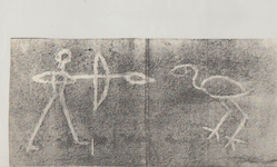
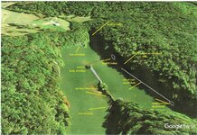
would like to talk or correspond with others about this area.. we kayak thru the gorge often, quite familiar with line of rocks, lid gap, Caney creek, Newcombe creek, laurel gorge.. and the cove near twin falls where the indian and crane is carved...

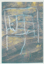
kayaked on upper big caney on south side of road opposite the boat ramp there couple days ago... near where the das is supposed to be carved according... to boomer... have few questions ...

interested in cooresponding if anyone interested...in talking about this area..... would love to hear from boomer of curtis? or any other researcher who is familiar with this area.....
 

OP
OP
G

gh65277

Jr. Member
Sep 30, 2016
25
124
Primary Interest:
All Treasure Hunting
So interested in this area in Elliott County..Caney and little Sandy river... we run kayak group and paddle these areas often ..

I own our old family farm near the lekain mines.. my grandma used to talk about silver mines nearby ...stamper property etc... I

Have read all ur post on treasurernet and am fascinated by all the research u have done.... I want to see as much of the carvings and cliffs u mention as I can.... love the historical finds...

So many questions to ask u... who do u think first carved the crane in the gorge? What era?..Do u think it was because of the mines there or just as a trace thru the area?....

Do u have picture of the old natural bridge at line of rocks? Do u have have old map showing the rocks across the river?....

I saw the indian and crane this past Friday for the first time... so faded... water down about 2 feet from summer pool.....u can still make it out but afraid it won't remain visible much longer...

U have worked hard on the research! I thank you....

Do u think these are the northern mines of JS... ?
 

Last edited:

boomer

Sr. Member
Jul 8, 2003
487
523
kentucky
Detector(s) used
army all terrain
glad you have the means to go slow on sandy river. there are 9 places that something is hidden and six old silver mines and an odd place called ghost hollow. late 1969 a man named Boggs showed me 5 vary poorly stamped gold coins and he had the mold to go with it. he was never able to find where they came from, but he said the coins were found up on johns creek at ghost hollow. the ghost hollow I have never been able to track down. put this in because somebody may know where to look. up at carter city there are four mines, has for the stamper farm, I was there and saw the snake carving and then a man named westfall decided to blow the hillside. bad idea. anyway the snake was marking a trail pointing toward carter city. the old mine is across from the old sandstone school up on the top of the cliff close toward the stop sign. will get maps and put them in later this week about the line of rock and the indian.
 

patiodadio

Hero Member
Feb 28, 2014
578
592
KY
Detector(s) used
Whites 4000D
Garrett ATPro
Primary Interest:
All Treasure Hunting
Any pictures of the Indian or Crane or any carvings etc ?
 

OP
OP
G

gh65277

Jr. Member
Sep 30, 2016
25
124
Primary Interest:
All Treasure Hunting
I kayaked this afternoon on little sandy river again.... took more pics from the indian carving and the crane... will post latest pics next few days..

Walked thru the rockhouse where the coins were found at line of rocks.. saw the stacked rock wall.... the big rock behind the wall with carvings... symbols... letters..numbers... not sure what they mean... saw rock cut out in the floor... smoother hole cut out looks where someone may have tried to hide something at one time... big rock adjacent appears to have been moved back exposing the carve out...

Saw a rock 10 foot long 5 or 6 feet wide... with little hatchet marks along the top... must have been 75 to 100 little 1/4 inch marks... like a notching of days or recorded events... very unusual...

Our farm is close to the stampers farm... old path went over crackerneck cliffs towards mcglone creek... grandma went to school with ole Charlie Stamper...

I know where the silver mine on the hill is across from the stone school in Carter City.... my dad went to that school 2nd grade on and graduated from there in 1954... he took me on the hill showed me the spring where the school used to get its water.. the silver mine is just on up the hill he said...

There at Carter City atop the hill up from jf lewis furniture store is the Olligunuk cave system... the cave on the left is called counterfeit cave.. grandma said in the 1920's when she was a small girl they found an Indian in that cave...

In the 1880's they were commercialised.. the train would stop in Carter from vanceburg.. people would rent old clothes and lanterns walk the hill and be guided thru the caves... in the 1970's when I was in high school we used to go in the caves often.. u could see old initials.. steps.. piles of dirt and rock they cleared passages for the tours...

Jf Lewis father also owned the property Carter Caves was on he sold it to the state in the 1940's to make the state park...

So interested in hearing about what u think is hidden in the 9 locations?.. u know so much about that area.. so impressed with ur research can not imagine hw much time u have spent researching all the things u share...

Who do u think carved the crane to begin with?
 

OP
OP
G

gh65277

Jr. Member
Sep 30, 2016
25
124
Primary Interest:
All Treasure Hunting
Dont know about the crane family..... according to printed material in one article boomer posted.. joseph Brandt came to Eastern KY in 1760 with a party looking for the crane carving....

If the carving was already there then.... doubt if the crane has anything to do with the Crane family.... being that early from the 1760's...

Hard to say.... guessing an Indian group prior to swift... or possibly their contemporaries...
 

EC.Mason

Hero Member
Feb 6, 2009
664
1,030
West Liberty Kentucky
Detector(s) used
Garrett AT Max
Primary Interest:
All Treasure Hunting
Hi gh65277. I live in Elliott and know much about the Little Sandy/Caney/Laurel area. Have studied the Chief Joseph manuscript a lot and studied the area. Drop me a message sometime.
 

boomer

Sr. Member
Jul 8, 2003
487
523
kentucky
Detector(s) used
army all terrain
PATIO: go back and look at my old posts on Grayson Lake and it will show the indian and crane and other carvings found there, as for the crane carving, the little sandy river was a main road south for the indian people to head south and tie in to routes heading though the pine mountains. there were a few carvings at the mouth of little sandy, one was a snake pointing south along the river, just like at the line of rocks at stamper farm and one I forgot about. there is one on Kinney creek just west of south shore ky. it points to a mine. use topo map to find this. go up kinney to a creek heading west called burnt cabin branch. on this branch on the left is the remains of a small furnace. at the mouth of this branch face east look kind of to the southeast and you will see a ridge line, up this low ridge you will find the old mine, part of the mine is caved in. as for the snake it Seems that the Indians used this sign to go to something important. GH: glad you told about how bad the carving are on sandy. where the carvings are, go around the corner on that small branch. look up and you will see + sign are a cross cut deep in cliff. on a 1953 Ariel photo on the flatland just past the end of the branch it showed four rocks about ten to 20 feet apart in the shape of the cross on the cliff. never got to go up there. looked on nasa world wind and it showed a barn close to where the rocks were. if you all need photos I can dig them out. later I will give you info on the line of rocks and how to get to the mines and this john, jon, alexander, Samuel, Seth swift.
 

OP
OP
G

gh65277

Jr. Member
Sep 30, 2016
25
124
Primary Interest:
All Treasure Hunting
Interesting stuff Boomer!... Have pics of indian and the crane i have took sev last couple weeks been out sev times recently..

What is the grid carving on the rock in front of indian and crane carving that faces river?... The rock shows a grid of straight lines and angles.. like a football field divided up into sections

Symbol or letters in middle same as in the rockhouse where coins were found... Looks like a 15 or a lJ.....or LS..... Have pics taken but no access just now to upload a file and put on this site..

Very interestong About the aerial photo s of a cross on top cliff...... By the branch with a cross or plus below... Again sounds simialr to the cross or plus carved in roof of rockhouse where coins were found.... I posted sev pics of these on the swift silver mine facebook site... But need home compitor working to upoad file on this site...

Any carvings near or on newcombe creek ? Seen what appears to be a pictograph on the cliff... Possibly a charcoal image of a scene.. boat.. someone standing up in the boat with arms extended... Very odd image... Not carved appears to be written or painted....but is below a ledge that could be a rockhouse 30 foot off the ground.... Was wondering if u knew of any carvings here or towards laurel gorge that may tie in to the caney creek area... Looking from aerial map the 5 fingers of the hand... This would be the far right finger... Farthest south...?
 

boomer

Sr. Member
Jul 8, 2003
487
523
kentucky
Detector(s) used
army all terrain
pictures

patio good point, here is a copy of the crane/indian rock. the next are of my two master treasure hunters. the photos of the rockhouse with the rocks piled up, glad they were posted. forgot one little thing. the civil war was fought on sandy all the way from sandy hook to Greenup ky. by general George Morgan who was retreating from john morgans troops. the main road was right up the little sandy river. so some of the carvings in that area may be southern or northern.
 

Attachments

  • indian and crane.png
    indian and crane.png
    1.2 MB · Views: 425
  • snace dogs.png
    snace dogs.png
    247 KB · Views: 364
  • spanish map.png
    spanish map.png
    520 KB · Views: 349
Last edited:
OP
OP
G

gh65277

Jr. Member
Sep 30, 2016
25
124
Primary Interest:
All Treasure Hunting
Nice pics boomer! Love pics... dogs... Gonna start another thread include some photos maybe u could help me to identify....
 

boomer

Sr. Member
Jul 8, 2003
487
523
kentucky
Detector(s) used
army all terrain
location of what to look for in the indian carving map. snake trail go toward line of rocks. body of indian carving,is the large rock in center of river. this rock stands 30 feet high and 6 feet thick. on top you will see hands cut into it, palms facing up. with circles in center and plus signs. look south along the river and up on side of cliff above the thin line of coal and there is another hand carved has a white color. photos face east. never got to check back of rockhouse where the bow is Shown. looks like rocks were put in back. shined a light and could see part of an opening, it seemed to go in direction of arrow on end of shaft. the arrow looking rockhouse is only about 10' wide and 6' deep. when I was there it looked to me like it was trimmed to look like an arrow.
 

Attachments

  • location indian crane.png
    location indian crane.png
    612.7 KB · Views: 610
  • location line of rock indian.jpg
    location line of rock indian.jpg
    373 KB · Views: 728
Last edited:
OP
OP
G

gh65277

Jr. Member
Sep 30, 2016
25
124
Primary Interest:
All Treasure Hunting
Very nice pics boomer..

Several comments... The rocks atop cliff does look like a cross... Drove the road around the rim of the gorge.. past old community of Ibez this past Monday after my paddle.. saw the house and barn near here...

The line of rocks... If it was a natural bridge or just rocks leaning against each other where u could cross the river... How does that figure into the waybill?... If the chest of the Indian was the pillar by line of rocks on the east of the river......and still remaining to this day.. then wonder why the natural bridges was not included in the waybill which would have been still standing in that era?..

This past Monday and Tuesday evenings after work I kayaked and explored some more on the waybill.. I went by hand carved on cliff at line of rocks.. u can still the white paint that bled down from each finger on the cliff... As it eroded...

Went left past the first rockhouse.. a trough like section just under cliff... Seen two holes uncovered where someone had been digging in the recent past... Went on to next shelter... Huge over hang where ceiling has collapsed over time.. huge boulders laying scattered on the floor... First thought this had happened after waybill then as I was scrambling around to me seen sev unusual marks on the rocks that may have been a path to follow thru the boulders... On a boulder..appeared to be a snake carving ... About 5 foot line... Did not look like a natural erosion spot...

Question first time u were here ..we're the huge boulders on the ground?... Wondering when the boulders fell and what might have been in the back of the shelter u mentioned?.. rocks stacked in Back? Could not really see much with huge boulders everywhere...

Went back to kayak and paddled around to next shelter to the left.... ..between this one and the rockhouse where the rocks are stacked I went up thru the cliff on what appears to be 3 carved Indian stair steps... Big arch rock in front of me u could see under the rock.. went right to a rockhouse along the ledge...... Cleaned out smoother floor with 2 piles of rocks stacked to the right on the edge of the shelter...

Continued to the right... The next climb up I stopped due to daylight.. I believe according to ur post if I go up here and turn right I come out at the arrow shaped shelter facing south west with 1762 carving...? My next goal next week...

I Know where the shelter with trees is located based on ur map and being back in that cove but have yet to climb up there and hike over... Am guessing the rainbow snake trail is that mid level cliff break between the lower cliff and higher cliff line.. is this correct?...

Where is swift and Mondays initials?
Believe I read where u commented they r in 2 places in the area but can't find that post as to where?...

Does the symbols x and + together mean anything..?

Seen this at line of rocks... Seen this in shelter where rocks are stacked. Across from line of rocks.... believe I have seen this on upper caney.. what appears to be the same.....?
 

CT1976

Jr. Member
Dec 23, 2013
42
44
Primary Interest:
All Treasure Hunting
Hey GH,
I closed down my Facebook, but for what it's worth the "X" and the "+" sound Spanish.
 

boomer

Sr. Member
Jul 8, 2003
487
523
kentucky
Detector(s) used
army all terrain
gh: the small rock house is directly behind the body of Indian next to the shore the three trees are long gone, but two of the small stumps were their in 2004. still wonder why he picks out that rock house and puts it in the waybill. you would not take time to say things about up on top of cliff and look inside at three trees. you would say go up to line of rocks. the head of Indian or the small cove shaped like a head, did you see that small rock house on your right on that small ledge near center of cove. forgot to tell you that a boy found a set of Spanish money molds and two hammers in corner. the family still has them. they live next to the old diamond mine. has for the rock house shaped like an arrow at summer pool i was able to put a boat up to the opening. has for the hands carved on the body on top and the one on side of cliff. the waybill never says anything about the hands, Spanish or French would use such a carving. as for the X or + the English used them more in Kentucky. the Spanish were big on sculpturing rocks to locate there hidden stores. I'll try to have the rest of the maps this week. we need a low winter pool at grayson lake some of the carvings are under water. like the ones at the mouth of cainey and the fingers of sandy.
 

OP
OP
G

gh65277

Jr. Member
Sep 30, 2016
25
124
Primary Interest:
All Treasure Hunting
Ok thanks for clearing this up... Have walked around woods and shelters there at line of rocks... Did not realize arrow shaped rockhouse was at ground level thought it was on top of cliff...

Grayson lake down 2 foot from summer pool... Still have 6 or feet to drop to winter pool... Can't wait to look more for carvings...

Want to get familiar with line of rocks is and where things are in relation to waybill before I move on to lid gap....

Prob going back there couple afternoons this week....

That area so much history there... Thank u for sharing this ... This story is fasinating to me...

Anything about who may have carved the crane or history regarding how anyone knew about the crane?... Is the waybill the only source for finding the crane?.. the original waybill... Did it have symbols or just words...
 

OP
OP
G

gh65277

Jr. Member
Sep 30, 2016
25
124
Primary Interest:
All Treasure Hunting
2 of 2 ..........can't wait to see the maps showing rock across little sandy... have looked for some time.... What indians used these trails? Shawnee? Miami? Cherokee?..
 

Top Member Reactions

Users who are viewing this thread

Latest Discussions

Top