The Indian Way Bill

franklin

Gold Member
Jun 1, 2012
5,036
7,168
Detector(s) used
Garrett ADS-7X, Fisher Two Box M-Scope, Mother Lode Locator, Dowsing Model 20 Electroscope, White's TM808, White's TM900, Inground Scanners
Primary Interest:
All Treasure Hunting
That is why some believe that Filson himself wrote the 'Journals', as a construct to lure more people into KY to sell land. Others think Boone was in on it because while on long hunts he was known to read from the latest novel by one Jonathan Swift, Gulliver's Travels. He named a creek after one of the characters in that novel not too far from Ft. Boonesboro and the Indian Old Fields (Eskippakithiki). I think it is called Lundegren Creek or something like that.
I have trouble with both of those theories because of their known characters and status. That would be dishonorable to mislead or to make a falsehood about Silver or a fictional man and build a story about treasure to lure people into the frontier like that. It would be beneath them to do such a thing.

What about John Filson being killed after a meeting with his partners in Lowlantsville, Ohio today Cincinnati, Ohio. He was killed on a creek going from the Ohio River to Lexington, Ky. His partners went on to be big land speculators maybe they used John Filson's knowledge and maps to invent the story and then they killed Filson because he did not go along with the story? Stranger things have happened.

There is low grade amounts of silver in Kentucky but I do not believe they are in paying amounts. I believe it was a land scam to get settlers across the Cumberland Mountains. It was outlawed at that time by the King of England. Daniel Boone and all the others kept forcing the Indians in to treaties to take more and more of their land. But anyway if J. Swift did any silver gathering it was most likely stolen on the Spanish Main carried into the mountains and smelted into coins.
 

jim bridger

Tenderfoot
Feb 13, 2017
9
40
Primary Interest:
All Treasure Hunting
I agree that it was a ploy to get more folks into central KY. The best sources for the circumstances surrounding his death are the biographies. I just finished the one by Walton and read the one by Durrett years ago, but need to refresh on it. There has been much speculation but few facts surrounding his death. The story is that he was killed north of the Ohio in an Indian ambush when he refused to wait for others during a return to camp. I agree that IF there was silver, the Spanish commercial ships were the source. I find it hard to conceive that a large party could move in and out of the mountains, leading slow-moving pack animals loaded with silver, for a decade. Stopping at outposts such as Castlewoods, wonder why local woodsmen didn't figure out Swift's scheme, ambush the pack train, bury the bodies, and move on with the silver. The "journal" throws a bone or two toward this point by telling about horses being stolen and loot buried, but I think it was an unbelievable undertaking for the time.
 

KY Hiker

Bronze Member
Oct 28, 2014
1,537
3,220
North Central Kentucky
Detector(s) used
Whites
Primary Interest:
All Treasure Hunting
These men that you are speculating about were of high moral character and not everyday scoundrels. The problem I have with the Filson ploy idea is the mining took place in the E. KY mountains. The majority of the land that was to be settled was through the bluegrass region of the state. That land being around and in between what is now Winchester/Lexington/Louisville and not the mountain region. The areas first settled were along the Ky River, Green River and the Falls of the Ohio River. It was easier to move goods for trade on the water than by wagon.
Lets not forget Col. Harrod, who disappeared while looking for the silver mines. The same Harrod who was in charge of the first settlement in KY, Ft. Harrod (Harrod station) or what is now Harrodsburg. A man who knew Boone and Filson.
 

KY Hiker

Bronze Member
Oct 28, 2014
1,537
3,220
North Central Kentucky
Detector(s) used
Whites
Primary Interest:
All Treasure Hunting
Although its just Wikipedia biographies, I thought I would link these to give some who may read this a brief on some of the leading men of early KY.
https://en.wikipedia.org/wiki/Swift's_silver_mine
https://en.wikipedia.org/wiki/Daniel_Boone
https://en.wikipedia.org/wiki/John_Filson
https://en.wikipedia.org/wiki/James_Harrod
https://en.wikipedia.org/wiki/Benjamin_Logan
https://en.wikipedia.org/wiki/George_Rogers_Clark

Most of these men were patriots, not men that would create falsehoods. They were busy fighting the British and protecting their families, not starting rumors of a silver mine to sell land.
 

franklin

Gold Member
Jun 1, 2012
5,036
7,168
Detector(s) used
Garrett ADS-7X, Fisher Two Box M-Scope, Mother Lode Locator, Dowsing Model 20 Electroscope, White's TM808, White's TM900, Inground Scanners
Primary Interest:
All Treasure Hunting
Have you read any of the Draper Manuscripts? Great reading about the people of the time. Also there were newspapers in Kentucky around that time. Read the stories and it tells where someone lived if they returned a horse or something to someone. Interesting reading.
 

KY Hiker

Bronze Member
Oct 28, 2014
1,537
3,220
North Central Kentucky
Detector(s) used
Whites
Primary Interest:
All Treasure Hunting
Have you read any of the Draper Manuscripts? Great reading about the people of the time. Also there were newspapers in Kentucky around that time. Read the stories and it tells where someone lived if they returned a horse or something to someone. Interesting reading.

Yes they do shed insight into the mindset and habits of ordinary settlers. Draper had a motive for collecting the stories and papers. It was his fear they would be lost to history or they would be overlooked as a people while the country was busy with further expansion West. Great collection and worth reading. I don't think any printing was done in KY until the late 1780's as far as newspapers go.

http://www.rootsweb.ancestry.com/~kyfayett/firstpaper.htm
 

Last edited:

franklin

Gold Member
Jun 1, 2012
5,036
7,168
Detector(s) used
Garrett ADS-7X, Fisher Two Box M-Scope, Mother Lode Locator, Dowsing Model 20 Electroscope, White's TM808, White's TM900, Inground Scanners
Primary Interest:
All Treasure Hunting
You may be correct but they are interesting. Chief Watt that was a partner with JS was found by those newspapers and where he lived in Kentucky. Don't you think he would have lived near where the silver mines was located. He was the one that kidnapped Jenny. He lived not too far from where John Filson was killed.
 

KY Hiker

Bronze Member
Oct 28, 2014
1,537
3,220
North Central Kentucky
Detector(s) used
Whites
Primary Interest:
All Treasure Hunting
You may be correct but they are interesting. Chief Watt that was a partner with JS was found by those newspapers and where he lived in Kentucky. Don't you think he would have lived near where the silver mines was located. He was the one that kidnapped Jenny. He lived not too far from where John Filson was killed.

Chief Watts was Swift's partner? Hmm new to me. I thought he was Cherokee and was in the TN/NC area. Raided some in the late 1780s into the 1790s I thought. Never knew him to live in KY or be involved with Jenny Wiley.

I had always heard that it was Shawnee and Chief Black Wolf involved with Jenny Wiley.

Maybe you are thinking of Mary Draper Ingles? She and another woman were taken by Shawnee in the 1750's, prior to the J. Swift story.

John Filson was supposedly killed in what is now Ohio, along the Great Miami River by Shawnee around 1788.
 

Last edited:

KY Hiker

Bronze Member
Oct 28, 2014
1,537
3,220
North Central Kentucky
Detector(s) used
Whites
Primary Interest:
All Treasure Hunting
So anyone, what is the answer to my question? Does Caney Creek fall in the '60-70 miles NE of Martin's cabin' range? Basically is it within 70 miles of Cumberland Gap area and is it North East of there? I can't seem to find it on modern maps of KY. And what about Grayson Lake area and the recent Silver slag found, is it too distance to be part of Filson's claim?

After a little more work on this I see that Caney is far outside the Filson claim of '60-70 miles NE of Martin's cabbin'. Whether it be modern map scale or using days traveled its way off. The Filson claim puts the supposed location somewhere on Pine Mountain, which is the 'great ridge' in some versions of the Swift Journal. Its also riddled with caves on both sides.
 

KY Hiker

Bronze Member
Oct 28, 2014
1,537
3,220
North Central Kentucky
Detector(s) used
Whites
Primary Interest:
All Treasure Hunting
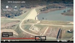
I don't remember if I posted this link or not, old photos of the Grayson Lake dam being built along with some modern drone footage of the general area...for those who have interest in the area and the similarities between the Indian waybill and the Swift Journal and the possibility of a silver vein being exposed during the dam construction.


EC.Mason

Hero Member
Feb 6, 2009
664
1,030
West Liberty Kentucky
Detector(s) used
Garrett AT Max
Primary Interest:
All Treasure Hunting
Reading this reminded me of something I had forgot. My grandmothers family (Skaggs) owned big and little Caney before they were bought out by the state. If you go down Caney creek, up the same little hollow on the left that a spring is cut in a rock, there is a large rockhouse that has been dug like crazy for Indian artifacts. At the mouth of the rockhouse are large rocks with squares cut into them. This is where my great great great grandfather had a barn. The ELIPE carving is close to this as well and can only be seen when water is low.

Anyways, concerning the mine that is in the curve coming down Caney from boat dock on the left (the one with the boulder over it) my great grandfather who grew up on Caney said when he was a boy he could go through a tunnel under that rock and come out on the other side of the rockhouse. I also remember a family member telling me he said there was a lead vein that crossed Caney somewhere in that area as well. Old stories I can't remember all the details ha ha.
 

EC.Mason

Hero Member
Feb 6, 2009
664
1,030
West Liberty Kentucky
Detector(s) used
Garrett AT Max
Primary Interest:
All Treasure Hunting
Wow. I know progress is great but can you imagine the history and the landscape destroyed when that was built. I know there used to be a small community that had to be moved for the lake. They dug up the local cemeteries and reburied them in the cemetery at Sandy Hook. Also, close to the dam on the left coming from Sandy Hook is an old house that had been moved up from the creek when the dam was built. This house was used by General George Morgan when he made his "Masterful Retreat" through what is now Sandy Hook and Grayson to get to the Ohio River. He stopped at this house and was dining with the owners (i'm thinking they were Hortons but I could be wrong) and his 8 to 10 thousand troops camped along the creek. There is a sign close to where you pull into Camp Webb Road (I think that's the right road) marking the spot. While General George Morgan was eating in this house, they were attacked by Confederate General John Hunt Morgan who, with only a couple hundred men, harassed the army on its retreat. I read somewhere that you could still see the bullet holes in the house. I've stopped and looked at it but its too old to tell what are bullet holes and what is just aging. Glad they saved the house but would love to have seen it in its natural state.


QUOTE=KY Hiker;6170527]I don't remember if I posted this link or not, old photos of the Grayson Lake dam being built along with some modern drone footage of the general area...for those who have interest in the area and the similarities between the Indian waybill and the Swift Journal and the possibility of a silver vein being exposed during the dam construction.

[/QUOTE]
 

EC.Mason

Hero Member
Feb 6, 2009
664
1,030
West Liberty Kentucky
Detector(s) used
Garrett AT Max
Primary Interest:
All Treasure Hunting
Its always been in the back of my mind if Morgans men seen or found anything pertaining to the manuscript as they traveled through the Little Sandy. 8-10 thousand men could cover a lot of ground. They were in a hurry so im sure they were not treasure hunting but would be interesting to see what they seen in the area. Ive detected a lot of artifacts from this march. Coolest thing I found was a brass eagle breast plate from a Union officer I found on the Little Sandy. Im rambling here ha ha. Its just an interesting area.
 

KY Hiker

Bronze Member
Oct 28, 2014
1,537
3,220
North Central Kentucky
Detector(s) used
Whites
Primary Interest:
All Treasure Hunting
Well, since your from the area and you had family that owned that land you should write down anything and everything you can recall of the area and the stories related to it. You might be one of the last links to that information! The tunnel was interesting and the carving always interested Boomer as I recall reading. Write it all down in notepad on your computer then copy and paste it here for us to read!
 

EC.Mason

Hero Member
Feb 6, 2009
664
1,030
West Liberty Kentucky
Detector(s) used
Garrett AT Max
Primary Interest:
All Treasure Hunting
Yeah I may do that. Just bits and pieces of stories ive heard. Not sure what all is true and what all is legend. I do believe you could enter that one mine and out the other end. That came from my great grandfathers son so handed down pretty well. There was another story of three men that my great uncle worked with in Maysville. In the 1960s he went to work in Maysville and told some co workers where he was from. One of them said he knew the place and asked if he knew of a certain landmark. My uncle said yes and one day the men drove down and looked at it. They dug (almost mined the rockhouse) several different days. If they found anything I don't know. My uncle said that they had a clue to something. If you come towards Caney boat dock on 504, coming from the prison, the rockhouse is on the left up a little hollow right before you turn to the boat dock. You can park on top of the hill and walk to it. Its literally not far off the road at all.

Another story is of a man who came to my great Papaw Emmitt and tried to buy the mineral rights on big Caney. Supposedly for silver. Emmitt agreed and the man said he would come back. The man never came back and years later as they were blasting the road for route 7 on Sandy, they found a skeleton that they thought was his. Again I do not know the validity of these stories as they were passed down through a few family members.
 

Last edited:
OP
OP
Curtis

Curtis

Hero Member
Sep 3, 2008
898
1,008
Cincinnati
Primary Interest:
All Treasure Hunting
Mason that was a great video, thanks for sharing! One of the pics shows the overflow area, I think that is where they may have hit silver ore. There is a silver vein that goes from the black box in the following copy of your pic and it goes all the way across the dam and into the hill. Its about 100 feet deep under the dam. Could have been one of Swifts mines? GR overflow silver.jpg
 

OP
OP
Curtis

Curtis

Hero Member
Sep 3, 2008
898
1,008
Cincinnati
Primary Interest:
All Treasure Hunting
back to your opening, I keep wavering from thinking the Swift mines are separate from the Indian way bill to thinking maybe they are. Only time will tell I guess.

By the way your grandpa solved a mystery for me. The first time I visited the mine under the rock house I remembered two places, and some beds carved into the rocks, they are not there now, maybe some of the roof fell in on that area.
 

Top Member Reactions

Users who are viewing this thread

Top