Indian Trace and pointer trees

KY Hiker

Bronze Member
Oct 28, 2014
1,537
3,220
North Central Kentucky
Detector(s) used
Whites
Primary Interest:
All Treasure Hunting
Decided this might need its own thread since I plan to do more investigation.
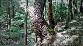
I found an Indian Pointer Tree on a weekend camping trip. Its on a drain one ridge over from where the Red River is joined by Swift Camp Creek. This drain is about 3 miles deep and full of laurel. Tree seems to point NW and is a pine tree that is over 100ft tall and just under 3ft in diameter. I back tracked from the pointer and it leads up and over the ridge through a narrow gap. Obviously just a trail pointer but interesting that I spotted it...I have passed through this area many times over the years and never noticed it.

Pictures are within this thread.
http://www.treasurenet.com/forums/lost-silver-mines-jonathan-swift/530130-swift-silver-20.html

Thanks to you all for making me 'look' for these signs. I normally would have missed this.
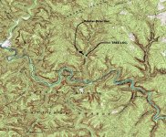
There are two natural arches in the general direction of the pointer on the opposite side of the creek up along the ridge. This tree is adjacent to a campsite that the locals used to use while hunting this drain. I noticed a pile of large stones on the opposite side of the camp site from the tree too. Campsite is where about 3 drains meet the creek, maybe a burial pile? or just stones piled when clearing the camp originally? I think I may have found part of the trail used by indians through the Red River Gorge. Next time I get out there I'll walk the pointer direction and see if there is another tree!

Forgot to mention, this drain is fed by a water fall...it disappears and reappears a couple of times before emptying into the Red River. Sounds like a passage from the Swift Journal ... I think it was called or named the drying ground? About 3-4miles further in the pointer direction is 'Indian Stairway' which is where the Frog's Head carving is... this may be something.... CopperasCreekTreeMap.jpg
 

Last edited:
OP
OP
KY Hiker

KY Hiker

Bronze Member
Oct 28, 2014
1,537
3,220
North Central Kentucky
Detector(s) used
Whites
Primary Interest:
All Treasure Hunting
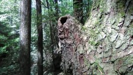
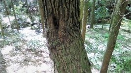
The Indian Pointer Tree pictures: IndianPtrTree1.jpg IndianPtrTree2.jpg IndianPtrTree3.jpg

More to come on my next visit to the area.
 

Curtis

Hero Member
Sep 3, 2008
899
1,009
Cincinnati
Primary Interest:
All Treasure Hunting
Great pics, as you know, the pointer trees symbolize several things, from water to treasure they say. I read about several in Ohio, near Athens, that seem to make a trail as they are a few hundred yards apart, and go for miles.
 

OP
OP
KY Hiker

KY Hiker

Bronze Member
Oct 28, 2014
1,537
3,220
North Central Kentucky
Detector(s) used
Whites
Primary Interest:
All Treasure Hunting
Yes, most of what I read online so far about them is they were trail or "indian hwy' markers used by the Cherokee. Pointing direction of travel along paths and safe fords across rivers. Some are said to be used to mark tribal hunting territory. Seems each tribe had their own ways and signs. Being in the RRG, this one should either be Cherokee or Shawnee....maybe Mecca, but not much is known about them. My guess is trail marker due to the depression or rut left coming down the hill to the tree above the creek. We'll see, I'm going to take tons of pictures, especially of the house sized boulders along the creek and the rock pile in the campsite. If I have enough time before dark, I want to follow the pointing direction (NW) and try to find another tree or other sign of trail/rut.
 

OP
OP
KY Hiker

KY Hiker

Bronze Member
Oct 28, 2014
1,537
3,220
North Central Kentucky
Detector(s) used
Whites
Primary Interest:
All Treasure Hunting
Well I made it down to the RRGorge this past weekend but was unable to break away and hike back this drain due to a refreshing afternoon thunder shower. I really didn't want to soak my camera or phone! So I'll try again next month...its not going anywhere anytime soon!

I did learn from someone while down there that there is another Indian trail tree along the user trail to Turtle Back Arch which points to that arch/down to Swift Camp Creek. This just adds to my theory... Turtle Back Arch sits above Swift Camp Creek and would be along the Indian Route going North and coming from: Station Camp Creek-KY River/ Beattyville to Lower Devil's Creek, along Lower Devil's Creek and probably splits one heading up toward Natural Bridge (left) the other going (right) then up and out in the Pine Ridge area and down along Rock Bridge Road to Turtle Back Arch and down into the Swift Camp Creek, then along Swift Camp Creek - cross the Red River and over to where I found the tree...from here maybe towards the Indian Stairway and/or Indian Creek and North towards Cave Run Lake/Beaver Creek areas.

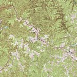
Here is a zoomable map of the area : https://www.topoquest.com/map.php?l...&zoom=16&map=auto&coord=d&mode=zoomout&size=m

PineRidgeTOPOIndianTraceMAP.jpg InkedPineRidgeTOPOIndianTraceMAP_LI.jpg
 

Last edited:

boomer

Sr. Member
Jul 8, 2003
487
523
kentucky
Detector(s) used
army all terrain
:dontknow:KY Hiker: in one of my old note books, before computers about 1971, don't laugh. it says ( across from mouth of swift camp creek is a creek flowing into red river from north called copperas creek. there are to paths go up creek to first branch on the left, there is an old trail going north to gladie creek. went on dry fork on the left and found a branch that is called silver mine. no early cravings, but 3 graves one had a bone that I could see. most of the info I got from hershel fowler on this next part. go up
copperas creek about halfway and you will see a water fall on the right.
my great grand father dalles fowler found some old mule shoes and 4 silver squares still in molds. the 2 trails go to beaver creek and frenchburg. so far this all I could find.
 

Curtis

Hero Member
Sep 3, 2008
899
1,009
Cincinnati
Primary Interest:
All Treasure Hunting
Wow! Silver still in the molds! How cool! Got to be a mine there someplace! Thanks Boomer as always you know how to get a persons blood flowing!
 

OP
OP
KY Hiker

KY Hiker

Bronze Member
Oct 28, 2014
1,537
3,220
North Central Kentucky
Detector(s) used
Whites
Primary Interest:
All Treasure Hunting
:dontknow:KY Hiker: in one of my old note books, before computers about 1971, don't laugh. it says ( across from mouth of swift camp creek is a creek flowing into red river from north called copperas creek. there are to paths go up creek to first branch on the left, there is an old trail going north to gladie creek. went on dry fork on the left and found a branch that is called silver mine. no early cravings, but 3 graves one had a bone that I could see. most of the info I got from hershel fowler on this next part. go up
copperas creek about halfway and you will see a water fall on the right.
my great grand father dalles fowler found some old mule shoes and 4 silver squares still in molds. the 2 trails go to beaver creek and frenchburg. so far this all I could find.

Thanks so much boomer, nice info! Two paths up the creek?... hmm there is a logging road on one side up higher than the creek.
That first part makes sense except Dry Fork should be Salt Fork...Silvermine Branch is off that. There is another Silvermine branch just upstream on the Red River. Interestingly Indian Staircase is above a drain that is off of Gladie Creek. Silver in square molds found on Copperas creek? The mule shoes make sense too, but could be from logging also. I'm really going to have to comb this drain, due to rainfall there are several waterfalls depending on the time of year. FYI, I would never laugh! I was 6 way back then :)

Link to a map of the area you were describing. Copperas headwaters in bottom right of map.
https://www.topoquest.com/map.php?l...nad27&zoom=8&map=auto&coord=d&mode=pan&size=m
 

Last edited:
OP
OP
KY Hiker

KY Hiker

Bronze Member
Oct 28, 2014
1,537
3,220
North Central Kentucky
Detector(s) used
Whites
Primary Interest:
All Treasure Hunting
I posted this link to an article written about Mrs. Timmins elsewhere but thought it might be pertinent to the Indian Trace through the Red River Gorge. The article is titled 'The Lone Woman of the Wilderness'. The author calls Mrs. Timmins Mrs. Perkins for some unknown reason. He makes mention of the traces and some description towards the end of the article. The location of her digging and the property she owned is roughly 4 miles South of where I found the trail tree and only a mile or less from the trail tree above Turtle Back Arch. Mrs. Timmins is the only documented Swift hunter with Journal in hand to claim to have found one of his workings, I find this significant and noteworthy.

https://chroniclingamerica.loc.gov/...lver&y=7&x=14&dateFilterType=yearRange&page=3
 

Rebel - KGC

Gold Member
Jun 15, 2007
21,680
14,739
The Indian Pointer Tree pictures: View attachment 1599645 View attachment 1599646 View attachment 1599647

More to come on my next visit to the area.
MIDDLE TREE is aka MESSAGER/MESSAGE TREE; messege is put in hole (such as requesting a mason jar of "Shine"). Mason jar of "shine" is put in hole; to be paid for with a GOLD Coin... deposited in that hole as payment. GC is in hole for the "dealer" to pick up... TRUE story in Franklin County, Va. & Page County, Va.
 

OP
OP
KY Hiker

KY Hiker

Bronze Member
Oct 28, 2014
1,537
3,220
North Central Kentucky
Detector(s) used
Whites
Primary Interest:
All Treasure Hunting
Thanks for that insight Rebel. Funny you mention shine, there is an arch South of this tree over on the other side of the ridge along and near the banks of the Red River called Moonshiner's arch...as it has a hole in it like a chimney.
 

OP
OP
KY Hiker

KY Hiker

Bronze Member
Oct 28, 2014
1,537
3,220
North Central Kentucky
Detector(s) used
Whites
Primary Interest:
All Treasure Hunting
Makes ya wonder, doesn't it...

YA! So was the one in VA. an Indian tree before it's 'other' use? FYI there were no jars/lids/mash in or around this tree... I didn't have a MT to check for coins! The campsite it was next too is very old and large, maybe 50x30 feet.
 

boomer

Sr. Member
Jul 8, 2003
487
523
kentucky
Detector(s) used
army all terrain
back in the 1970s just outside of morehead ky. I met the great grand daughter of Anne Oakley the famous shooter. she took me to a place on the licking river just east of beaver creek. from what I remember this small creek ran into the river on the west side and was shaped like a horse shoe heading back to the licking river. it was called silver mine branch or mine branch. we followed a vary old path that was completely overgrown. she said this is it, pointing to a small tree that was bent and the end was stuck in a tree 6 feet away, the people notched the tree so the bent tree would fit in to it and bond that way. that's when I learned about marker trees and walk 50 yards stop and do a 360 degree sweep of your surroundings. if a tree grows in a place where little sun hits the tree. it could look young but may be over a 100 years old. the reason the small tree was set into the larger tree was telling you that a hidden opening was near by and follow the bent tree to the place where the opening is. that's why the small tree was notched into the large tree. dig here. now about the lady her name was Polly Oakley,she lived outside of morehead and was 82 years old and carried an old colt 45. her old trailer was like a museum. I was with Paul Hughes and Paul Henson and all three will tell you, never, never try to keep up with her. if she says its just over here. go on youtube look up Indian pointer trees USA. some interesting trees shown there.
 

OP
OP
KY Hiker

KY Hiker

Bronze Member
Oct 28, 2014
1,537
3,220
North Central Kentucky
Detector(s) used
Whites
Primary Interest:
All Treasure Hunting
I'll be back down to walk the path in a couple of weeks. I am itching to get back there and see where this points to and what I may find. I'm bringing the camera to take pictures...lots of pictures. I have watched several videos on Indian pointer trees, seems they were used by both Eastern and Western tribes. Some have profound bends to where they almost defy gravity.
 

Top Member Reactions

Users who are viewing this thread

Latest Discussions

Top