great ridge

Ken S.

Hero Member
Oct 1, 2018
577
1,615
Paintsville,Ky.
Primary Interest:
Other
I'm not trying to interject myself into this "argument", I really don't care about the Swift legend at all but while you guys are trying to pin down this "great ridge"...perhaps throw this into the mix for debate.

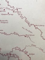
The Mount Sterling to Pound Gap Road aka The State Road. Official work began in 1817 so one would think that it was a trail or trace way before that. It's pretty much modern day US 460. The area beginning in Frenchburg and going east were called "The Dry Ridge" during that time. I have a vague map that shows that the Dry Ridge was a rather large piece of real estate.

460 Actually crosses through the same Gap that New river runs through Near Ingles Ferry, on its way from N. Carolina's Yadkin Valley to join with Gauley River to form the Kanawha At Gauley Bridge W.Va. or at Kanawha Falls.
 

Last edited:

Ken S.

Hero Member
Oct 1, 2018
577
1,615
Paintsville,Ky.
Primary Interest:
Other
Don't know about that end ,but they have jacked rt numbers around on this end to the point 460 is 3 -10 miles of where it was 40/50 years ago. If one wasn't around before the changes it would be a feat just to track the old route down.
 

Ken S.

Hero Member
Oct 1, 2018
577
1,615
Paintsville,Ky.
Primary Interest:
Other
Sorry 1320 about the short answer on the wrong end of the trail. Could it be that the road was built mostly along a ridge ??? Many times the name was derived from land features or a distinguishing land mark back in the day. That is one piece of road I don't remember ever driving. It is a great big piece of ground Frenchburg to W Liberty
 

Last edited:

KY Hiker

Bronze Member
Oct 28, 2014
1,537
3,220
North Central Kentucky
Detector(s) used
Whites
Primary Interest:
All Treasure Hunting
Last edited:

1320

Silver Member
Dec 10, 2004
3,434
2,308
East Central Kentucky
I haven't found any passages or place name data that give "The Dry Ridge" it's name. I can say with certainty that the name comes up frequently during the Civil War era.
 

Attachments

  • dryridge.jpg
    dryridge.jpg
    1.3 MB · Views: 80

Ken S.

Hero Member
Oct 1, 2018
577
1,615
Paintsville,Ky.
Primary Interest:
Other
The elevation may be the reason for its name. It seems that the valleys through that area are as much as 300 ft. higher in elevation than W. Liberty or Frenchburg. Just my take on what info I can come up with.
 

KY Hiker

Bronze Member
Oct 28, 2014
1,537
3,220
North Central Kentucky
Detector(s) used
Whites
Primary Interest:
All Treasure Hunting
I haven't found any passages or place name data that give "The Dry Ridge" it's name. I can say with certainty that the name comes up frequently during the Civil War era.

Interesting map! Thanks.

I have a link to the topo map of the area between W. Liberty(top right on map) and Hazel Green(bottom left on map)....lots of streams cut through there draining toward the Licking.

https://www.topoquest.com/map.php?l...=16&map=auto&coord=d&mode=pan&size=m&cross=on

DryRidgeAreaTOPO.jpg

I wonder if this same 'dry ridge' is the area mentioned in some journals that says something about poor timber?
The 'Great Ridge' is supposedly oriented NE-SW and this Dry Ridge is opposite NW-SE...
 

Last edited:

Ken S.

Hero Member
Oct 1, 2018
577
1,615
Paintsville,Ky.
Primary Interest:
Other
Would be any ones guess. Maybe reverse deception ??? 
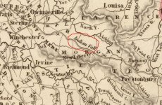
Old Field lay just north of the area of Dry ridge don't it ?
 

Last edited:
OP
OP
rgb1

rgb1

Sr. Member
Nov 24, 2013
295
769
s.w. Ohio
Detector(s) used
2 whites 1 garett
Primary Interest:
All Treasure Hunting
there is a dry ridge within 10 miles of the mines i found dont think its same one its not in that exact area
 

KY Hiker

Bronze Member
Oct 28, 2014
1,537
3,220
North Central Kentucky
Detector(s) used
Whites
Primary Interest:
All Treasure Hunting
Last edited:

1320

Silver Member
Dec 10, 2004
3,434
2,308
East Central Kentucky
I have come across one reference to The Dry Ridge as having "a lot of scrub growing along it's route". That particular reference gave me the impression that it was desert like at the time.

On a few older maps, there's an area labeled "Indian Field" that looks to be somewhere between Frenchburg and West Liberty, or Frenchburg-Prestonsburg. Too far away to be confused with Eskippakithiki. One old timer told me that this Indian Field was located near the Swamp Valley museum (Denniston/Wellington) but I just can't make it work in my mind. I'll see if I can track one of those maps down for clarity, not that it helps much with the mines.
 

KY Hiker

Bronze Member
Oct 28, 2014
1,537
3,220
North Central Kentucky
Detector(s) used
Whites
Primary Interest:
All Treasure Hunting
It might help, if it is the poor timbered area described in some journals. Also, think about this, if a mine was worked and furnaces fired over a 10 year period they would have cut a good chunk or lumber down to make their charcoal. That might account for brush/younger forest.
Pine Ridge got its name from its almost legendary fine pine groves that it had. I have read somewhere that on Swift Camp Creek the oldest Hemlock in Kentucky can be found and the tallest White Pine (or visa versa). I have seen both in that valley with trunks around 4ft in diameter.
 

Last edited:

Ken S.

Hero Member
Oct 1, 2018
577
1,615
Paintsville,Ky.
Primary Interest:
Other
I was under the impression Old Indian Fields was between W. Liberty and Ezel Or the general area.
 

Last edited:

1320

Silver Member
Dec 10, 2004
3,434
2,308
East Central Kentucky
Here's a snip from one map that shows the Indian Field that I and perhaps Ken are referring too, map dated 1845. Ken is correct, this Indian Valley looks to be along the Licking River near West Liberty. Notice is was called New Liberty back in the day. I've seen one other map that calls the area Indian Fields, this is the first that I've seen that references it as "Valley". Also, you can see the Mt. Sterling-Pound Gap road on this map (parts of it).
 

Attachments

  • IndianVall.JPG
    IndianVall.JPG
    117.6 KB · Views: 76

KY Hiker

Bronze Member
Oct 28, 2014
1,537
3,220
North Central Kentucky
Detector(s) used
Whites
Primary Interest:
All Treasure Hunting
Looking towards the top of that map, shows Louisa on the Little Sandy...also can see West Fork on right edge which would be West fork of Big Sandy. Also a long meandering ridge between the Red and KY rivers. Do you know the date of this map 1320?

Never mind found it online, 1845...

Louisa is shown twice on the little and big sandy!
 

Last edited:

Top Member Reactions

Users who are viewing this thread

Top