what if journal fabricated to protect the location of the mines

rgb1

Sr. Member
Nov 24, 2013
295
769
s.w. Ohio
Detector(s) used
2 whites 1 garett
Primary Interest:
All Treasure Hunting
the swift journal i believe was only fabricated to protect the mines he did not start it till the second trip he would have been familar with the areas in the journal because he was an indian trader before the mines he could have used the areas of travel for his deceptions what better way to lead people away if this is true it would be a brilliant idea and has worked for two hundred and fifty years give me your thoughts and ideas thanks.
 

KY Hiker

Bronze Member
Oct 28, 2014
1,537
3,220
North Central Kentucky
Detector(s) used
Whites
Primary Interest:
All Treasure Hunting
the swift journal i believe was only fabricated to protect the mines he did not start it till the second trip he would have been familar with the areas in the journal because he was an indian trader before the mines he could have used the areas of travel for his deceptions what better way to lead people away if this is true it would be a brilliant idea and has worked for two hundred and fifty years give me your thoughts and ideas thanks.

My only question about this theory is... why make the journal at all, just keep your mouth shut about where it is should do the same thing. If the legend is true and the journal was written by a man named Swift, it is more likely that the journal was altered/edited/deleted in part by persons driven by greed through the years. They being the deceivers and not Swift.
If someone had the original in hand and tried to find a mine and had no luck, imagine them copying it over and altering it, then selling it in multiple copies. 20-30years later each of the owners of the fakes have similar ideas and do the same... this, I think, is why we have 30+ different versions floating around. Meanwhile the original is tucked away somewhere in a private collection, or turned to ash in a cabin fire, or rotted with the corpse of a searcher who never returned, like Col. Harrod? This too would explain why after 250 years the mine(s) have not been discovered.

That is why I say, someone with 15 or more versions of the journal on hand should refine them down to all the common points... that would be the first step to finding the truth...the basics of the journal. Otherwise your searching based on a hunch, a prayer and a lot of faith. The most common journal says that the rich mine was hidden, closed, and all evidence of their workings was removed. It could literally be 20 yards from a common trail with people passing by it regularly and no one would know! Or it was written that way to provoke thousands to continue to look for something that isn't there to be found?
 

Last edited:
OP
OP
rgb1

rgb1

Sr. Member
Nov 24, 2013
295
769
s.w. Ohio
Detector(s) used
2 whites 1 garett
Primary Interest:
All Treasure Hunting
thanks for the reply hiker i believe i now have a copy of the original journal when i show it to you i believe you and cortis will be surprized at what i have found thats why i decided to write the book and why i have been so secretive about things still have some more research to do will get with you down the road not now just yet will let you know still have to make several trips to ky. more things to check out. want to do this right in truth as best as i can.
 

Ken S.

Hero Member
Oct 1, 2018
577
1,615
Paintsville,Ky.
Primary Interest:
Other
I doubt the original journal was written to deceive or cover up the location. BUT!!! who knows which one is the original, or if it still exists today ? The thing people today has lost touch with is, the reality of the way people traveled back in those days. Most can't take a compass and map and travel through the woods from one place to another and I could go on for a while about other things but there's no need.
 

KY Hiker

Bronze Member
Oct 28, 2014
1,537
3,220
North Central Kentucky
Detector(s) used
Whites
Primary Interest:
All Treasure Hunting
I'm not so sure Swift had a compass, not the kind of thing that was portable in the 1760s-1800s. Best bet is he used common Indian/buffalo traces and landmarks to navigate along with some form of dead reckoning at a certain time of day, using the sun and a rod in the ground instead of a compass heading, and his carvings. This is why the journal(s) are so vague in my opinion.

https://en.wikipedia.org/wiki/Dead_reckoning
 

Ken S.

Hero Member
Oct 1, 2018
577
1,615
Paintsville,Ky.
Primary Interest:
Other
I figure he used the tool the captains at sea used to navigate . the name of it escapes me right at the moment but it used the stars and heavenly bodies to let them know where they were at. Most people today was the ones I was saying most can't take a compass and travel through the woods.
 

KY Hiker

Bronze Member
Oct 28, 2014
1,537
3,220
North Central Kentucky
Detector(s) used
Whites
Primary Interest:
All Treasure Hunting
Yes and the principles of a sun dial to determine the time of day using the rod. Not super accurate but along with landmarks and his marks... a combination had to be used. Which reminds me something about his journal, it should be more specific than it usually appears, if it was actually written as a journal 'as it happens'. The journals always read as if it was written afterwards. Think about a captains log on a ship, it should read similar to that than what we have available to read in the journals. Pretty much convinced the journal was written after his return and either during or prior to his search to re-find the mines.
 

Curtis

Hero Member
Sep 3, 2008
899
1,009
Cincinnati
Primary Interest:
All Treasure Hunting
Swift had a more primitive instrument, he could figure latitude pretty close, but in his time longitude was tough and took a lot of complex calculations to figure...until a reliable time piece came along longitude was very open to mistakes. Also you have to know which one of several sources of meridian was used. In his time there were 4 or 5..one of which was Philadelphia, one off the coast of France/Spain, and of course Greenwich..plus more. I will take him at his word of the lat. but question the long.
 

franklin

Gold Member
Jun 1, 2012
5,036
7,168
Detector(s) used
Garrett ADS-7X, Fisher Two Box M-Scope, Mother Lode Locator, Dowsing Model 20 Electroscope, White's TM808, White's TM900, Inground Scanners
Primary Interest:
All Treasure Hunting
Swift had a more primitive instrument, he could figure latitude pretty close, but in his time longitude was tough and took a lot of complex calculations to figure...until a reliable time piece came along longitude was very open to mistakes. Also you have to know which one of several sources of meridian was used. In his time there were 4 or 5..one of which was Philadelphia, one off the coast of France/Spain, and of course Greenwich..plus more. I will take him at his word of the lat. but question the long.

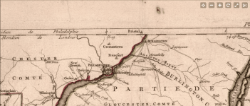
A map 1777 was off 9 minutes or about 7.4 miles west from Philadelphia. Screenshot_2019-11-13 Virginie, Maryland en 2 feuilles par Fry et Jefferson .png
 

KY Hiker

Bronze Member
Oct 28, 2014
1,537
3,220
North Central Kentucky
Detector(s) used
Whites
Primary Interest:
All Treasure Hunting
Swift had a more primitive instrument, he could figure latitude pretty close, but in his time longitude was tough and took a lot of complex calculations to figure...until a reliable time piece came along longitude was very open to mistakes. Also you have to know which one of several sources of meridian was used. In his time there were 4 or 5..one of which was Philadelphia, one off the coast of France/Spain, and of course Greenwich..plus more. I will take him at his word of the lat. but question the long.

With a pole/rod/staff the time could be determined on a sunny day similar to a sun dial...yes that is not very accurate but it works in a pinch.
 

KY Hiker

Bronze Member
Oct 28, 2014
1,537
3,220
North Central Kentucky
Detector(s) used
Whites
Primary Interest:
All Treasure Hunting
A map 1777 was off 9 minutes or about 7.4 miles west from Philadelphia. View attachment 1771021

We know that now, would they have known that then? If Swift was from Alexandria and a patriot, he most probably used the Philly meridian. But before the war, considering themselves subjects to the crown, wouldn't they have used the London meridian? I doubt (if the journals dates are true) he would have been using any map in the frontier in the 1760s. Following traces, waterways, landmarks and man marks was the most probable methods he used.
 

Curtis

Hero Member
Sep 3, 2008
899
1,009
Cincinnati
Primary Interest:
All Treasure Hunting
There are too many instances where the people of the time had to choose which meridian, Swift may have been English but he could have used French or Spanish or other meridian to throw people off...lets think about that for a minute, he could write what he wanted as the correct long and lat. but used a non familiar meridian...and only he knew it..pretty smart eh? Also helps to understand why none has found it.
 

KY Hiker

Bronze Member
Oct 28, 2014
1,537
3,220
North Central Kentucky
Detector(s) used
Whites
Primary Interest:
All Treasure Hunting
Four different meridians...hmm, plot them out on a map for us? It would be interesting to see. If you know the difference in the meridians it would be simple math. You can plug the coordinates in a free online topo like this one.

38 N 83.5 W https://www.topoquest.com/map.php?l...nad27&zoom=8&map=auto&coord=d&mode=pan&size=m

Yep that is Beaver Creek and Cave Run Lake (yea another dam), the same Beaver Creek Boomer talked about several times on here. Some 15 or 20 miles North of the Red River Gorge. Always seems to come back to this region of the state.
 

Last edited:

Ken S.

Hero Member
Oct 1, 2018
577
1,615
Paintsville,Ky.
Primary Interest:
Other
It would be a simple thing to figure all of the points out by simple research. You can find all the meridians of the time on the internet I'm sure .
 

Top Member Reactions

Users who are viewing this thread

Top