You are using an out of date browser. It may not display this or other websites correctly.
You should upgrade or use an alternative browser.
You should upgrade or use an alternative browser.
MEQUACHAKE INDIANS
- Thread starter rgb1
- Start date
KY Hiker
Bronze Member
- Oct 28, 2014
- 1,537
- 3,220
- Detector(s) used
- Whites
- Primary Interest:
- All Treasure Hunting
The Indians named the creek rich creek? Is this near or off of Blaine Creek? That is a natural route West for Swift! Lucky you! Seems odd doesn't it, they usually have Indian names in their own language?
There is a similar story on the North side of Red River along Spaas Creek. There was found the remnants of a permanent Indian camp either above along the cliffs or along a branch of it now called Camp Branch, its the next fork up from Blackburn Branch where the picture was posted on here was taken of his grave site along a cliff wall.
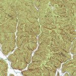
Here is a topo map of that area.

Last edited:
Curtis
Hero Member
Someone said some of the tribes also moved from place to place and often named an area they visited. Since Swift named them as having been there maybe in the past the location would be very old(duh).Old campgrounds would have a lot of "refuse" piles...found one over by the boat landing on Caney...has thousands of fresh water oyster shells...covers about an acre.
KY Hiker
Bronze Member
- Oct 28, 2014
- 1,537
- 3,220
- Detector(s) used
- Whites
- Primary Interest:
- All Treasure Hunting
The Indian camp should be a close by clue to the mines spoken of in the Swift journal. I always imagined a hunting camp, but it just as easily could have been a seasonal camp ground for migrating Indians. Those fresh water muscle shells are not necessarily evidence of a camp ground, I have walked up on those before on sand bars that have gone through a drought the year before. If you come across one after a dry spell in the hot Summer they smell to high heaven!
Top Member Reactions
-
 2351
2351 -
 1135
1135 -
 1046
1046 -
 886
886 -
 828
828 -
 802
802 -
 756
756 -
 752
752 -
 606
606 -
 496
496 -
 495
495 -
 471
471 -
 466
466 -
 423
423 -
 388
388 -
 380
380 -
 376
376 -
 375
375 -
 372
372 -
O
371
Users who are viewing this thread
Total: 2 (members: 0, guests: 2)


