swifts return

rgb1

Sr. Member
Nov 24, 2013
295
769
s.w. Ohio
Detector(s) used
2 whites 1 garett
Primary Interest:
All Treasure Hunting
when swift returned he said he was looking for his mines or was he? being blind no way could he mine anything if he was looking for his mines it had to be for 1 reason if he found the mines it would be only because he would know his way to the supposed great cave if it was close by to the mines i believe the great cave to be only a deception and is a smaller cave in the vicinity of the mines mabey im wrong otherwise why would he search for the mines i do not think it worth while what he left in the mines to count on his extended time of existence but if he could locate the mines and then the cave nearby he would be able to pay his help and still live comfortably the rest of his life give me your thoughts thanks.
 

1320

Silver Member
Dec 10, 2004
3,434
2,308
East Central Kentucky
This is one of many reasons why I have absolutely zero faith in this legend. Allegedly, Swift knew the exact latitude and longitude of a mine or set of his mines correct? Maybe that was injected into the legend as it was rewritten and retold countless times? If anyone believes that Swift knew the coordinates at any point, you'd be foolish to believe that he couldn't relocate the mine(s) with a little bit of help.

rgb1, you have a good point. If in fact Swift knew the coordinates, he certainly was looking for something else upon his blind return.
 

KY Hiker

Bronze Member
Oct 28, 2014
1,537
3,220
North Central Kentucky
Detector(s) used
Whites
Primary Interest:
All Treasure Hunting
when swift returned he said he was looking for his mines or was he? being blind no way could he mine anything if he was looking for his mines it had to be for 1 reason if he found the mines it would be only because he would know his way to the supposed great cave if it was close by to the mines i believe the great cave to be only a deception and is a smaller cave in the vicinity of the mines mabey im wrong otherwise why would he search for the mines i do not think it worth while what he left in the mines to count on his extended time of existence but if he could locate the mines and then the cave nearby he would be able to pay his help and still live comfortably the rest of his life give me your thoughts thanks.

I believe, but cannot prove with any facts that he was not blind at all. His sight was most likely failing him because of age and/or the smelting process if anything. If he was able to read but not make out a tree type or a familiar face from any short distance would be debilitating if looking for land marks and other marks leading to his workings. It is quite possible that the blindness and the great cave were both additions to the legend as it was passed on. We all know how stories grow over time.
Remember also, I am not a big believer in the journals as they are written either...they don't read like a journal would be written as it was happening but rather written in past tense like a telling of his travels. My theory is the journal, if he wrote one, was dictated by him and written down as he told it. This would have taken place DURING his return in search of finding his workings. Mrs. Timmins claimed to have had his original journal and map of the immediate area. My theory is the map and journals were sold by him and/or his search party to fund their search efforts and spread the word of the mines. There is a documented story of a man who lived in the Red River Gorge area who helped Swift and party when they were lost. He even claimed to help try and nurse Swift back to health. In that story I don't believe there was any mention of Swift being blind, but lost.
It is also probable that he was not looking for the mines but all the stashes of coin, bars or ore and not a cave at all. I have heard people call rock houses caves though, maybe that is the twist?
Just my $0.02

P.S. Hope everyone here is doing well and keeping their sanity during this out break of China Flu.
 

Last edited:

KY Hiker

Bronze Member
Oct 28, 2014
1,537
3,220
North Central Kentucky
Detector(s) used
Whites
Primary Interest:
All Treasure Hunting
This is one of many reasons why I have absolutely zero faith in this legend. Allegedly, Swift knew the exact latitude and longitude of a mine or set of his mines correct? Maybe that was injected into the legend as it was rewritten and retold countless times? If anyone believes that Swift knew the coordinates at any point, you'd be foolish to believe that he couldn't relocate the mine(s) with a little bit of help.

rgb1, you have a good point. If in fact Swift knew the coordinates, he certainly was looking for something else upon his blind return.

Yep I have to agree, it is highly unlikely he had the coordinates for the mine in any detail pre 1800 this far inland. At sea movement is linear and distance can be calculated by wind strength/speed. Overland moving up and down hills and twisting through creek beds and following traces, distance is hard if not impossible to figure. I have come across 3 different sets of coordinates supposed to be from journals, even depending on the various meridians used at the time none can pinpoint anything using today's topo maps and GPS. The closest that ever made sense was one that pointed to a ridge near Beaver Creek which is partially under Cave Run Lake now.
 

1320

Silver Member
Dec 10, 2004
3,434
2,308
East Central Kentucky
Yep I have to agree, it is highly unlikely he had the coordinates for the mine in any detail pre 1800 this far inland. At sea movement is linear and distance can be calculated by wind strength/speed. Overland moving up and down hills and twisting through creek beds and following traces, distance is hard if not impossible to figure. I have come across 3 different sets of coordinates supposed to be from journals, even depending on the various meridians used at the time none can pinpoint anything using today's topo maps and GPS. The closest that ever made sense was one that pointed to a ridge near Beaver Creek which is partially under Cave Run Lake now.

As best I can tell, Cave Run Lake didn't partially cover any ridges, especially along Beaver Creek. Hit me with the topo map of the ridge unless it's something that you'd like to keep under wraps, I would completely understand.
 

KY Hiker

Bronze Member
Oct 28, 2014
1,537
3,220
North Central Kentucky
Detector(s) used
Whites
Primary Interest:
All Treasure Hunting
As best I can tell, Cave Run Lake didn't partially cover any ridges, especially along Beaver Creek. Hit me with the topo map of the ridge unless it's something that you'd like to keep under wraps, I would completely understand.

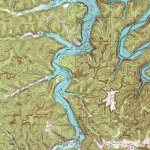
Naaaw I don't keep secrets on here, I'm all about sharing knowledge...sorry for the confusion I didn't mean the ridge was under water. Just the center of map is on a ridge at Cave Run Lake. It could be anywhere in a 4mile radius of the center of the map linked below.
Here is 38N 83W (Paintsville Lake) https://www.topoquest.com/map.php?l...nad83&zoom=8&map=auto&coord=d&mode=pan&size=m

And this one is 38N 83.5W (Cave Run Lake) https://www.topoquest.com/map.php?l...nad83&zoom=8&map=auto&coord=d&mode=pan&size=m

here is the map for people to keep if they want it

Swift Journal coordinate map 38N 83.5W.jpg

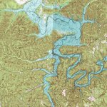
Here is a wider view of the area

Beaver Creek Cave Run Lake.jpg
 

Last edited:

KY Hiker

Bronze Member
Oct 28, 2014
1,537
3,220
North Central Kentucky
Detector(s) used
Whites
Primary Interest:
All Treasure Hunting
Seems I recall Boomer having a thread talking about Beaver Creek. Another about Wynn Branch off 460 too. He seemed to have high interest in this area at one point. Another about teakettle rock but I don't remember where that one was...but the rock was a map of sorts in his interpretation, but it seems like it was in the RRG-Cave Run Lake region if my memory serves me well.

Anyway, what I am getting at is there were a lot of posts on TNet that pointed to this area. There was an Indian Trace N-S through the RRG it ran from Natural Bridge S.P. area up the Whittleton Arch Trail generally then followed Tunnel Ridge Road and dropped into Auxier Branch, crossed the Red River near the mouth of Indian Creek where a crane is carved on a rock and followed Indian Creek North up to 460 near Frenchburg. I got the Tunnel Ridge Rd info from a USFS employee a couple years ago. There have been found pottery shards around the Greys Arch parking area and some carvings along the D. Boon Hut trail, both are considered prehistoric and not from woodland Indians.
 

Last edited:

1320

Silver Member
Dec 10, 2004
3,434
2,308
East Central Kentucky
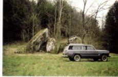
Tea Kettle rock is actually three rocks that are resting on each other. The attached image is credited to Boomer, he took this photo in the 80’s.

Tea Kettle is located in Menifee County, in Clifton Branch, or Clifty if viewing older maps. Approximately 1 mile from Beaver Creek. I can verify the carvings are on the rock however, I would never say that they can be accredited to Native Americans. The hominy holes however are there, several of them, they are identical in form to many others that I’ve seen in the area.

I have no idea how Tea Kettle ended up being associated with the Swift legend, most likely conjecture. A fine gentleman named Vernon Spratt was adamant that Tea Kettle was a link, he used heavy equipment in the vicinity but never found a shred of evidence.
 

Attachments

  • 9E0F1FA3-AB78-48E3-8CFC-B5BA8D318E57.jpeg
    9E0F1FA3-AB78-48E3-8CFC-B5BA8D318E57.jpeg
    39.9 KB · Views: 222
  • 35A2365B-2D2F-4F84-8542-8C2D47F3B7D7.jpeg
    35A2365B-2D2F-4F84-8542-8C2D47F3B7D7.jpeg
    32.2 KB · Views: 224
Last edited:
OP
OP
rgb1

rgb1

Sr. Member
Nov 24, 2013
295
769
s.w. Ohio
Detector(s) used
2 whites 1 garett
Primary Interest:
All Treasure Hunting
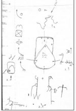
i could be wrong this to me appears to be a spanish map do not believe to be part of swift ledgen
 

KY Hiker

Bronze Member
Oct 28, 2014
1,537
3,220
North Central Kentucky
Detector(s) used
Whites
Primary Interest:
All Treasure Hunting
Tea Kettle rock is actually three rocks that are resting on each other. The attached image is credited to Boomer, he took this photo in the 80’s.

Tea Kettle is located in Menifee County, in Clifton Branch, or Clifty if viewing older maps. Approximately 1 mile from Beaver Creek. I can verify the carvings are on the rock however, I would never say that they can be accredited to Native Americans. The hominy holes however are there, several of them, they are identical in form to many others that I’ve seen in the area.

I have no idea how Tea Kettle ended up being associated with the Swift legend, most likely conjecture. A fine gentleman named Vernon Spratt was adamant that Tea Kettle was a link, he used heavy equipment in the vicinity but never found a shred of evidence.

That is from the Boomer thread that I remember, I still don't understand why it was called tea kettle...I see no resemblance to a tea kettle. I don't remember anything about maps being drawn on rocks in any of the Swift Journals...as rgb1 said, it looks like Spanish cryptic carvings. So it was in the same area as Beaver Creek though, interesting...
 

Rebel - KGC

Gold Member
Jun 15, 2007
21,680
14,739
COULD be symbolic "blindness" for him, as in the masonic degree of the York Rite... PROBABLY the Cryptic Masonry Degree.
 

Last edited:

KY Hiker

Bronze Member
Oct 28, 2014
1,537
3,220
North Central Kentucky
Detector(s) used
Whites
Primary Interest:
All Treasure Hunting
Yes they do blindfold them for certain rituals. Good catch Rebel. A throw back to all the 101's found too...
 

KY Hiker

Bronze Member
Oct 28, 2014
1,537
3,220
North Central Kentucky
Detector(s) used
Whites
Primary Interest:
All Treasure Hunting
The Jonathon Swift researched in Mr. Prather's book was a Mason and belonged to the same Alexandria lodge as G.W. There are theories that the whole Swift legend/story is an allegory laced with masonic clues.
Perhaps the Great cave of the Shawnee is really a relation to this...https://www.thoughtco.com/the-allegory-of-the-cave-120330
 

Last edited:

KY Hiker

Bronze Member
Oct 28, 2014
1,537
3,220
North Central Kentucky
Detector(s) used
Whites
Primary Interest:
All Treasure Hunting
rgb1 back to your original point, I do recall reading one version of the legend saying that Swift was chasing a wounded bear into a cave and discovered the silver that way. So the mine was a cave in that version...maybe the great cave was great because of the silver within it? I recall a story someone brought forth here on Tnet about an Indian Princess buried in the cave. Every time I think back to that though I think about Mammoth Cave and the mummified Indians found within it.
 

OP
OP
rgb1

rgb1

Sr. Member
Nov 24, 2013
295
769
s.w. Ohio
Detector(s) used
2 whites 1 garett
Primary Interest:
All Treasure Hunting
this is how things get confused it was mundy and his father and brother that chased the wounded bear they found silver in the cave and started to work this and abondoned their old workings this is where the indians killed his brother and father and took mundy captive
 

Last edited:
OP
OP
rgb1

rgb1

Sr. Member
Nov 24, 2013
295
769
s.w. Ohio
Detector(s) used
2 whites 1 garett
Primary Interest:
All Treasure Hunting
i believe it was mundy and his brother and dad chaseing a wounded bear and found the cave with the silver they were later killed and mundy captured later mundy showed a mine toswift this was in the story of swift in hensons version
 

KY Hiker

Bronze Member
Oct 28, 2014
1,537
3,220
North Central Kentucky
Detector(s) used
Whites
Primary Interest:
All Treasure Hunting
Honestly, this is the first I have ever heard any mention of Mundy's family, usually it is just Mundy.
 

Top Member Reactions

Users who are viewing this thread

Top