Pictures of Swift's Items

rgb1

Sr. Member
Nov 24, 2013
295
769
s.w. Ohio
Detector(s) used
2 whites 1 garett
Primary Interest:
All Treasure Hunting
TABLE TOP ROCK.jpg

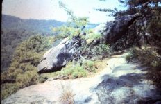
Swift's Table Top Rock or Balance rock Picture 1

TABLETOPROCK WITH BUFFALO ROCK.jpg

Table Top Rock with Buffalo Rock Picture 2

4TH SWIFT MINE.jpg

4th Swift Mine
 

OP
OP
rgb1

rgb1

Sr. Member
Nov 24, 2013
295
769
s.w. Ohio
Detector(s) used
2 whites 1 garett
Primary Interest:
All Treasure Hunting
very dreary day rain top picture is flat on top like a table sits on a point about 3 feet in diameter and does apear similar to a table
next picture is showing buffalo rock below rock that appears on right bottom is actually 20 feet away..poor judgement when picture taken did not realize when picture was taken
3rd. picture shows partner trying to drain water this mine was covered and matched conture of slope.
pictures taken 1984 poloroide camera
the buffalo rock is on other side of ridge from first picture
 

Last edited:
OP
OP
rgb1

rgb1

Sr. Member
Nov 24, 2013
295
769
s.w. Ohio
Detector(s) used
2 whites 1 garett
Primary Interest:
All Treasure Hunting
have not looked for it .
 

KY Hiker

Bronze Member
Oct 28, 2014
1,537
3,220
North Central Kentucky
Detector(s) used
Whites
Primary Interest:
All Treasure Hunting
After seeing these pictures I realize you may be right on track rgb1. The third picture looks to be a natural opening rather than a typical mine opening. This might be your cave. You may want to PM me as I have seen the exact first picture before. In September of 2018 as best I can remember.

Just to be frank, there are at least 6 known balanced rocks in E KY probably more on private land. Most well known is at Natural Bridge S.P. (there are actually two there but they don't let anyone near the second one anymore as they deem it too dangerous).
Picture of it is on Henson's blog page link http://ed-henson.blogspot.com/2013/02/red-river-gorge-past-years.html

OriginalBalancedRock.jpg

People used to stand on it and try to get it to teeter-totter, but the cliff it is balanced on is over 100ft and sheer. State park closed off the little trail to it years ago due to safety issues. Now by law you have to stay on the trails in the S.P. no exploring anymore.
 

Last edited:
OP
OP
rgb1

rgb1

Sr. Member
Nov 24, 2013
295
769
s.w. Ohio
Detector(s) used
2 whites 1 garett
Primary Interest:
All Treasure Hunting
this is not a cave the walls are square cut same as top this is the 4th mine on same property i will get pictures of other mines they are on opposite side of mtn. this mine only goes another 40 ft into side of hill and stops .at back wall
 

KY Hiker

Bronze Member
Oct 28, 2014
1,537
3,220
North Central Kentucky
Detector(s) used
Whites
Primary Interest:
All Treasure Hunting
this is not a cave the walls are square cut same as top this is the 4th mine on same property i will get pictures of other mines they are on opposite side of mtn. this mine only goes another 40 ft into side of hill and stops .at back wall

PM sent, the opening looks natural in shape ... looks L shaped in a way, maybe it started as a cave and got worked? Another couple of questions, do you have a ridge-top arch to the East or West of the ridge your mines are on? Is the ridge the mines are on run North to South or visa versa? Just indicators/landmarks from Swift Journals...these help verify.

My only reservation in the picture is the area doesn't look clifty as described in the journals. But, that could have been another way to deceive.
 

Last edited:
OP
OP
rgb1

rgb1

Sr. Member
Nov 24, 2013
295
769
s.w. Ohio
Detector(s) used
2 whites 1 garett
Primary Interest:
All Treasure Hunting
PM sent, the opening looks natural in shape ... looks L shaped in a way, maybe it started as a cave and got worked? Another couple of questions, do you have a ridge-top arch to the East or West of the ridge your mines are on? Is the ridge the mines are on run North to South or visa versa? Just indicators/landmarks from Swift Journals...these help verify.

My only reservation in the picture is the area doesn't look clifty as described in the journals. But, that could have been another way to deceive.

the reason the opening looks l shaped is because we are just starting to open it contour matched slope on west side there is an arch ridge runs north and south you will not belive the deceptions i have found it is all in my book probably will be another year though there is cliffs close by i am still doing some research still doing some investigation on catche sites also saddle is on west side
 

Last edited:
OP
OP
rgb1

rgb1

Sr. Member
Nov 24, 2013
295
769
s.w. Ohio
Detector(s) used
2 whites 1 garett
Primary Interest:
All Treasure Hunting
know who sent it to you he and i were talking if you look you will see this picture in my personal info also this is where he got it
 

Top Member Reactions

Users who are viewing this thread

Top