Looking for old Virginia maps...Brunswick/Nottoway counties

N

njmoore

Guest
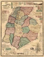
Hello. I am researching the age of my parent's property in Brunswick county and I am interested in finding maps that may have their home marked. I have searched through some of the map sites listed in other posts here with no luck.

I am also interested in finding locations of old roads and trails through the area. If you know of any resources online or otherwise that I could use please let me know. Thanks for looking!
 

OP
OP
N

njmoore

Guest
Thank you for the link. I had that one already though :o. It doesn't show the house or any of the other buildings marked on there.

They traced the house back to 1880 before they quit digging for clues. I'm wondering if I can find a map from about that time that may show the house and whatever some of the old foundations near it are. Also maybe what roads were there at the time.

I appreciate the help. I had just found that site in another thread before I posted here.
 

OP
OP
N

njmoore

Guest
Thanks again. I emailed. We'll see what happens.

I'm still open for more suggestions if anyone else has any ideas.
 

OP
OP
N

njmoore

Guest
Well, it isn't that close to a town. In the map I found from the 1860's these areas are what I am interested in...
Jonesborough
Wildcat Creek
Daniel's Mill

The nearest town there these days is in the area of Daniel's Mill on that map and is called Danieltown.

I guess the easiest way to explain it is the Northwest corner of Brunswick County Virginia.
I've been searching high and low on the internet and haven't found anything that great. I may have to take a trip to the local library next time I am up there and see what they have available.

Thanks for the help.
 

D

Daveman

Guest

Attachments

  • Frederick-Co.-MD-1858-2.jpg
    Frederick-Co.-MD-1858-2.jpg
    17.4 KB · Views: 1,376
  • Frederick-Co.-MD-1858-2.jpg
    Frederick-Co.-MD-1858-2.jpg
    17.4 KB · Views: 618

Top Member Reactions

Users who are viewing this thread

Latest Discussions

Top