Where can I find these old COUNTY maps????

ModernMiner

Gold Member
Jan 9, 2007
13,951
4,146
North Carolina
🥇 Banner finds
5
🏆 Honorable Mentions:
6
Detector(s) used
Minelab Manticore , Tesoro Silver uMax
Primary Interest:
All Treasure Hunting
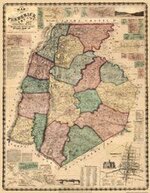
Hello. I see a lot of you out there have these neat old county maps that show where old churches, school houses, etc. used to be.
Any tips on where I can find those? I've looked on E-bay, but they just have the large whole state maps.
I am interested in Wake County and Ashe County in North Carolina in particular.Any help would be greatly appreciated.
Thanks.
 

camb1

Bronze Member
Dec 11, 2006
1,592
317
Southern Illinois
Detector(s) used
Minelab Excalibur 1000 & Explorer SE
Primary Interest:
All Treasure Hunting
Check your local Historical Society. But I wouldn't say anything about m-detecting. Some people are funny about it. Just say your a history buff and would like to know more about the area. Also here is a link if you know someone at NCSU.

http://www.lib.ncsu.edu/gis/historic.html
 

jeff of pa

Super Moderator
Staff member
Dec 19, 2003
85,836
59,622
🥇 Banner finds
1
🏆 Honorable Mentions:
1
Primary Interest:
All Treasure Hunting
the best source for my area, has been EBay.

I didn't see your county listed, but check once a week.

Type in wake atlas & then wake map
north carolina atlas & them north carolina map.
maby even carolina atlas & carolina map

Don't forget to check the EBay stores

and look for 19th. century atlas' or maps from them.
Sometimes you can find them on CD's for $30.00

while original Atlas' can sell anywhere from $100.00 up

an Example from PA

http://search.ebay.com/pa-county-atlas_W0QQfromZR40
 

Diggincoinz

Bronze Member
Dec 19, 2004
1,581
212
Wayne County, NY
Detector(s) used
Minelab X-Terra 70 / Tesoro TigerShark / Fisher F70
Primary Interest:
All Treasure Hunting
You may also try looking at this website.

http://historical.maptech.com/index.cfm

Choose your state, find your quadrangle of the area you are looking into. I think most of what's available there are survey maps dating around 1898-1900 but shows all homesteads and roads at the time. In my area, I see roads that used to be there and are now only partial road, dead ending to residences then picking up on the other side of the creek beds. Tells me to go detecting along the old part of the road that hasn't been traveled in 75yrs.
 

Junk Monkey

Greenie
Dec 10, 2005
14
9
Atlanta, GA
Detector(s) used
Whites V3I, Whites DFX and Fisher F75.
Don't know if this site was ever mentioned, http://memory.loc.gov/ammem/gmdhtml/gmdhome.html
but I found an unbelievable amount of old maps here, free for the downloading.
They even have a free reader for beautiful close-ups of the maps. The reader is located at http://www.lizardtech.com/. Just click on "download a free viewer". You wont be disappointed with the quantity and quality of the maps, especially the old Civil War maps.
.
 

D

Daveman

Guest

Attachments

  • Frederick-Co.-MD-1858-2.jpg
    Frederick-Co.-MD-1858-2.jpg
    17.4 KB · Views: 780

FLauthor

Hero Member
Aug 22, 2004
770
203
Minneola, FL
Detector(s) used
Excalibur 800; Fisher F5; White Beachmaster VLF
Primary Interest:
Beach & Shallow Water Hunting
Go to my article on this page: Hundreds of sites available in your state! ;)
 

Gypsy Heart

Gold Member
Nov 29, 2005
12,686
339
Ozarks
Some of the best books that I have bought havve been from abebooks.com
They have plenty of old map books, books on your county etc
 

Top Member Reactions

Users who are viewing this thread

Top