D
Daveman
Guest
Some of our best sellers are county land ownership maps, but with such a huge variety available our internet gallery awards the browsing public with a choice. Because only part of the collection has ever been digitalized, we are able to locate early maps of our customer preferences.
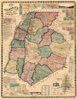
Our maps are restored archival replicas that are sharp in resolution, the majority are in color and are available at a reasonable price. These maps are not poor scans, but of high quality. These items were originally large wall maps of extremely large dimensions and had to be reduced in size, yet still are very readable and highly sought after by treasure hunters, prospectors, family genealogist's and a very large group of map enthusiasts.
If your interested in early county maps of "Say", Austin, TX, we have them, including Austin, TX County maps. Amongst our considerable library of Maps, Texas County maps are one of our land ownership collections. Meaning they have the original property owners name and the extent of their land purchased. In addition, many of these maps will show the whereabouts of old, forgotten graveyards. The early maps indicated everything including the sites of homesteads at that time.
Contemporary maps however, hardly, if ever show the location of early home sites. Many of county land ownership maps, have been reduced digitally because of the original size would have covered a wall. But nothing has been lost in the transcription. Even so, these are large and most of these land identity maps display inserts of towns and small villages in that era. They are remarkable because Joe the Blacksmith shop will be shown, along with schools, churches, public buildings, hospitals, asylums jails, banks, professional business just to name a few.
Each archival replica is produced on large format printers in glorious color and at premium prices.
As of today, most of this valuable information has disappeared. Even demographic details of rivers that have changed course, to crossings where wooden ferries delivered wagons, men and horses to the other bank. The majority of these stunning heir-looms have had their original hand-coloring restored. Although we address the condition of the map, we never completely remove the patina of age.
Maps of the Past, Inc.
http://www.historicmapsrestored.com