Can somebody clarify the symbols on this map?

TrpnBils

Hero Member
Jan 2, 2005
870
1,234
Western PA
🥇 Banner finds
1
🏆 Honorable Mentions:
1
Detector(s) used
CTX 3030
Primary Interest:
Metal Detecting
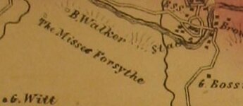
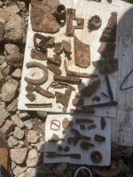
This is off of an 1861 map of my family's property and I'm trying to get a handle on a few symbols here because no key is available. Specifically, what is the difference between the solid black squares, and the hollow squares? I did well in this area over the weekend, and this tiny section shown here opens up the possibility of up to 20 buildings that are no longer there....I just need to know what I should be looking for based on what this map is saying.
 

Attachments

  • mapcapture.JPG
    mapcapture.JPG
    17.8 KB · Views: 208

TheRingFinder

Bronze Member
May 22, 2013
2,223
1,991
Minnesota
🏆 Honorable Mentions:
3
Detector(s) used
Minelab - E-Trac / Excalibur
Primary Interest:
All Treasure Hunting
Per the USGS Topographic Map Symbols Guide - Any blackened square or hollowed square is a "building" of some sort. The Key buildings like a church or school had symbols on top of the square. I suppose they couldn't have a symbol for all the different types of buildings, such as barns, houses, outhouses, chicken coops etc............
 

TheRingFinder

Bronze Member
May 22, 2013
2,223
1,991
Minnesota
🏆 Honorable Mentions:
3
Detector(s) used
Minelab - E-Trac / Excalibur
Primary Interest:
All Treasure Hunting
BTW - I can't enlarge the Picture for some reason, so tough to see everything.........
 

OP
OP
TrpnBils

TrpnBils

Hero Member
Jan 2, 2005
870
1,234
Western PA
🥇 Banner finds
1
🏆 Honorable Mentions:
1
Detector(s) used
CTX 3030
Primary Interest:
Metal Detecting
That's all the larger the picture is - it's just a snip from a full map I have. I thought I had read somewhere before that hollow boxes were barns or other outbuildings and solid squares were inhabited buildings, but I can't find a reference to that anywhere now in any of the keys I've seen. What doesn't make sense to me, with that in mind, is that on this piece of the map I see two hollow boxes on the left side ("B. Walker" and "The Misses Forsythe") by themselves. It wouldn't make sense to have a barn be the only structure on your property....which is why I'm back to "what's the difference?" as far as research goes. Right now though, none of those houses there that are visible on that map are still standing, although I only know where two of them were for sure. Although I don't really remember it, I lived in the one on the lower left corner there for about the first two years of my life...and then spent the next 30 hiking around the area where all of the rest of them were supposed to have been and don't remember ever seeing any foundations or anything.
 

cw0909

Silver Member
Dec 24, 2006
4,364
3,222
Primary Interest:
Other
if the map has the map maker/ co., look him up maybe there will
be a map key/legend on one of his other maps with same symbols
 

mcl

Sr. Member
Sep 26, 2014
419
411
Primary Interest:
Other
Hello. Generally those empty squares represent unoccupied buildings, whether they are barns, sheds, or abandoned houses. Here's a snippet of a map that I think illustrates pretty well.

ex.png

You say you've seen no evidence of homes where you've walked, so let me give you a couple of things to think about. The other markings around those properties look like they have either river bottom or prairie markings. The properties have only unoccupied buildings at this point. Given that these buildings were not lived-in and were built in some kind of wilderness, it wouldn't be too outrageous to assume they may have been built on, for example, wood posts rather than some sort of more permanent material. Taking into account the environment, the age of the plat map in question, and the nature of the properties and buildings, it doesn't seem out of the question that their existence would be "invisible" today. Just a thought, hope it helps.
 

Top Member Reactions

Users who are viewing this thread

Top