BuffaloBob
Bronze Member
- Jan 6, 2005
- 1,367
- 262
- Detector(s) used
-
Minelab X-Terra 705 Gold Coil
deteknixXpointer Probe
Minelab Ex-Terra 70
White's Classic II
2014-2015 Colorado Gold Camp Prospector
- Primary Interest:
- Metal Detecting
Novum Instrumentum Geometricum (1607)
Illustrations from Leonhard Zubler’s Novum Instrumentum Geometricum (1607). Zubler was a Swiss goldsmith and instrument maker who is credited with introducing the use of the plane table into modern surveying. This book demonstrates the use of his instruments in techniques of triangulation, particularly in the context of warfare.
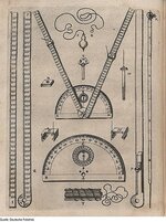
Those were the basic map making tools. Remember hpw you found a gtreat fishing spot (before nav equipment) you sighted 3 objects on shore. Similar techniques for these guys.
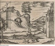
Pretty slick those ancient surveyors. Once you are trained on how to use the measuring tools, it was easy. Well maybe not but how else could they do it?
To see more pix visit the site:
BB
Novum Instrumentum Geometricum (1607) | The Public Domain Review


