Topo accuracy with Google earth ?

diggerdoodah

Jr. Member
Dec 1, 2013
70
22
Primary Interest:
All Treasure Hunting
Ok you map gurus I am over laying topos on GE . My question is how accurate are topos from 1902 with GE . I found the Long and Lat cross hairs On GE back in 1998 to match up the corners. But the real question I am after is how accurate are the house squares marked on the map going to be with 1998 corners. So far just one 1902 map I have over 30 house marked (most are in open field on current GE ) and not even 1/4 way through the map .

Map info
scale 1/125000
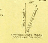
declination look like it says 32 degrees
DEC.PNG


Thank for any help
 

1637

Bronze Member
May 26, 2011
1,774
2,421
tujunga ca
Detector(s) used
xlt mxt gmz and now a gmt whites
i have a map from 1878 and its really close.do five of them, then go check them and you will know how close your map is.
good luck let us know how it works out.
brad
 

ChampFerguson/TN

Bronze Member
Nov 22, 2013
1,181
1,620
TN
Detector(s) used
Minelab Safari .......... Minelab Excalibur II ....... ........Minelab CTX 3030
Primary Interest:
Metal Detecting
I have the answer: It Depends.
I have seen old topos line up so well that I thought someone had manipulated them and some line up so badly that I think the houses are different. (and you obviously know about declination/magnetic pole drift)

I once toured the USGS/TVA facility in Chattanooga where topos were plotted out from the aerial data and was shocked at how inexact the process was. I'm sure its better now, but this was in the 70's. Think about that when you compare the tech then with the state of the art in 1900.

My advice is to consider topos very good in a rough sense, but be ready to poke around once you get on site.
 

Clay Diggins

Silver Member
Nov 14, 2010
4,885
14,257
The Great Southwest
Primary Interest:
Prospecting
Your scale 1/125000 topo has a maximum precision of about 200 feet. That means the very best located feature on the original topo will be within 200 feet of it's actual location. The actuality is that very few map features will be anywhere near that accurate. More like a 1/4 mile on the original topo for general accuracy of features.

That's for the original topo which is probably in a long ago Polyconic projection. Once you combine it with Google in a made up non standard projection (900973) based on a much more modern WGS 84 geographic model you end up with a mutt. Projections matter a lot and although georeferencing a few corners can get you closer you really need to reproject the maps to match projections. Google products can not reproject or even change projections so your tools are incapable of making any more than a stretched and warped copy of the topo. Stretched and warped are not terms that are compatible with accurate mapping.

IF you have the GE "terrain" and 3D features turned off you might reasonable expect accuracy within 3,000 feet for some features on your topo but not all. If you have the terrain and 3D features on you can throw any locational accuracy out the door.

More modern topos are created by stereographic pairs of aerial photos as ChampFergusonTN correctly pointed out. That method is MUCH more accurate than the earlier hand drawn topos like your 1909. Stereoplotters are still in use today and they are still the most accurate terrain mapping method. Modern topos have a scale of 1/24000 which is much more accurate than your 1/125000 topo. Generally features on modern topos are within 40 feet of their ground location about 60% of the time. The same rules apply when you put those 1/24000 topos on google earth - accuracy goes way down.

The declination is probably 3.2 degrees. I'm not sure 32 degrees declination is even possible. The middle of the pacific ocean is only 20 degrees declination. I'm not sure why the declination would matter unless you are triangulating with a magnetic compass. The topo, google and a GPS unit already have declination figured in. Magnetic drift will have virtually no effect compared with the scale of map and the native google earth inaccuracy you are encountering.

You can see a chart of the different resolutions used for topos on this page. There is also a link there to a map that will allow you to download any topo or shoreline survey, modern or historic, ever made in the U.S. You might just find there is a much higher resolution topo of your area of interest from the same period that will have the information you need.
 

Last edited:

Top Member Reactions

Users who are viewing this thread

Top