Beers map abbreviations?

HeatherM

Jr. Member
Apr 12, 2020
95
131
Central Kentucky
Detector(s) used
Garrett ATPro
Primary Interest:
All Treasure Hunting
I cannot find a legend or abbreviation list for the D. G. Beers maps anywhere including on the dang map. Can anyone tell me what S.S and S.H (school house?) stand for?
CE4B36CB-2DDB-4E8F-A968-8745FB1D24CC.jpeg
 

Noah_D

Bronze Member
Dec 14, 2017
1,593
3,491
Illinois (prev. NE Ohio)
🏆 Honorable Mentions:
1
Detector(s) used
Nokta Makro Simplex+, Garrett ACE 300, Carrot
Primary Interest:
Metal Detecting
SH is usually schoolhouse. I don't know about SS, but one time I threw out that it could mean steam sawmill. The problem was that it appeared on maps that were made before steam sawmills were in use.
 

OP
OP
HeatherM

HeatherM

Jr. Member
Apr 12, 2020
95
131
Central Kentucky
Detector(s) used
Garrett ATPro
Primary Interest:
All Treasure Hunting
A friend told me it could mean survey stone? How boring.
 

ANTIQUARIAN

Gold Member
Apr 24, 2010
12,841
27,385
Upper Canada 🇨🇦
🥇 Banner finds
1
🏆 Honorable Mentions:
3
Detector(s) used
XP Deus, Lesche Piranha 35 Shovel & 'Garrett Carrot'
Primary Interest:
Relic Hunting
Could it possibly mean 'Stage Stop', similar to today's 'bus stop'? :icon_scratch:
They look to be a few miles apart.

Dave
 

VTColonialDigger

Hero Member
Oct 13, 2016
804
2,104
Vermont
Detector(s) used
Garrett Ace 400
Primary Interest:
Metal Detecting
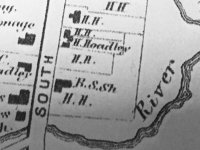
Noah D is right about S.H. standing for School House, however I have another theory about what S.S. could mean. I have noticed that on a lot of old maps, especially Beer's maps, if an owner had a lot of property in one area of town, the owner's name would be written once, and then after that just the owner's initials would be written.
Here's an example:
OldMapSection.jpg

H. Hoadley owned a lot of land in this part of town according to the map. H. Hoadley was put once, and then after that just the initials "H.H."

So maybe "S.S." stands for the owners initials.

I hope this help!
 

Last edited:
OP
OP
HeatherM

HeatherM

Jr. Member
Apr 12, 2020
95
131
Central Kentucky
Detector(s) used
Garrett ATPro
Primary Interest:
All Treasure Hunting
Noah D is right about S.H. standing for School House, however I have another theory about what S.S. could mean. I have noticed that on a lot of old maps, especially Beer's maps, if an owner had a lot of property in one area of town, the owner's name would be written once, and then after that just the owner's initials would be written.
Here's an example:
View attachment 1837620

H. Hoadley owned a lot of land in this part of town according to the map. H. Hoadley was put once, and then after that just the initials "H.H."

So maybe "S.S." stands for the owners initials.

I hope this help!

Interesting! That is very useful knowledge. I will check the map again and see what the nearby owners names were. I'm just learning how to interpret the old maps and they can be very frustrating!! I feel like I keep getting nowhere and all I want to do is find some new interesting places that haven't been detected to death!
 

Mackaydon

Gold Member
Oct 26, 2004
24,083
22,860
N. San Diego Pic of my 2 best 'finds'; son & g/son
🏆 Honorable Mentions:
2
Detector(s) used
Minelab Explorer
Primary Interest:
Shipwrecks
You may wish to contact the Woodford County Historical Society and ask them.
[FONT=&quot]Phone: (859) 873-6786[/FONT][FONT=&quot]E-mail: [email protected][/FONT][FONT=&quot]on Facebook:[/FONT][FONT=&quot] [url]https://www.facebook.com/WoodfordKyHistory[/URL]
They may also be able to refer you to the local historian.
Don.......[/FONT]
 

VTColonialDigger

Hero Member
Oct 13, 2016
804
2,104
Vermont
Detector(s) used
Garrett Ace 400
Primary Interest:
Metal Detecting
Interesting! That is very useful knowledge. I will check the map again and see what the nearby owners names were. I'm just learning how to interpret the old maps and they can be very frustrating!! I feel like I keep getting nowhere and all I want to do is find some new interesting places that haven't been detected to death!

If your're looking for new sites, another tool that is really helpful for locating new sites is Lidar. It shows elevation of the Landscape. It is done by state, I see your're in Kentucky, I don't know, but they might have it. It is great for locating cellar holes. It takes a learning curve but a tip is that cellar holes show up as small squares. Look in remote/wooded areas and you might find a cellar hole that isn't marked on any maps, these are usually the old ones.

If you do a Google search for "Kentucky Lidar" you can probably find out if they have it or not.
 

OP
OP
HeatherM

HeatherM

Jr. Member
Apr 12, 2020
95
131
Central Kentucky
Detector(s) used
Garrett ATPro
Primary Interest:
All Treasure Hunting
OP
OP
HeatherM

HeatherM

Jr. Member
Apr 12, 2020
95
131
Central Kentucky
Detector(s) used
Garrett ATPro
Primary Interest:
All Treasure Hunting
If your're looking for new sites, another tool that is really helpful for locating new sites is Lidar. It shows elevation of the Landscape. It is done by state, I see your're in Kentucky, I don't know, but they might have it. It is great for locating cellar holes. It takes a learning curve but a tip is that cellar holes show up as small squares. Look in remote/wooded areas and you might find a cellar hole that isn't marked on any maps, these are usually the old ones.

If you do a Google search for "Kentucky Lidar" you can probably find out if they have it or not.

Thank you for the tip. I have been trying to learn to recognize cellar holes/foundations and old roads like on google earth and it has not been easy. Maybe it will be more noticeable on that site. i'll check it out tonight!
 

Noah_D

Bronze Member
Dec 14, 2017
1,593
3,491
Illinois (prev. NE Ohio)
🏆 Honorable Mentions:
1
Detector(s) used
Nokta Makro Simplex+, Garrett ACE 300, Carrot
Primary Interest:
Metal Detecting
Thank you for the tip. I have been trying to learn to recognize cellar holes/foundations and old roads like on google earth and it has not been easy. Maybe it will be more noticeable on that site. i'll check it out tonight!

Here's an availability map of the 1-meter DEMs, the 1-meters are the most useful bc of the resolution. It doesn't look like Ky has much coverage yet though, neither does Ohio :BangHead:.
https://www.usgs.gov/media/images/1-meter-dem-availability-conus-only
 

Mackaydon

Gold Member
Oct 26, 2004
24,083
22,860
N. San Diego Pic of my 2 best 'finds'; son & g/son
🏆 Honorable Mentions:
2
Detector(s) used
Minelab Explorer
Primary Interest:
Shipwrecks
On the original map you will notice the residence of S. Seearce directly and immediately to the west of what you posted.
My guess is the "S.S." is the location of other structures (homes?) owned S. Seearce and abbreviated as 'SS'.
Don....
 

Noah_D

Bronze Member
Dec 14, 2017
1,593
3,491
Illinois (prev. NE Ohio)
🏆 Honorable Mentions:
1
Detector(s) used
Nokta Makro Simplex+, Garrett ACE 300, Carrot
Primary Interest:
Metal Detecting
On the original map you will notice the residence of S. Seearce directly and immediately to the west of what you posted.
My guess is the "S.S." is the location of other structures (homes?) owned S. Seearce and abbreviated as 'SS'.
Don....

I like the idea but why would SS be on some of the maps I am looking at of NE Ohio?
 

Top Member Reactions

Users who are viewing this thread

Top