Gypsy Heart
Gold Member
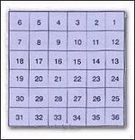
Each Township-and-Range square, called a “township” for short, is usually (but not always) 6 miles on a side and contains 36 square “sections.” Sections are numbered from the northeast corner by “boustrophedon,” (boos-truh-FEED-un) a two-dollar word that means “as the ox plows.” Section 22 is almost in the middle.
One section = 1 square mile = 640 acres. Townships vary but sections are constant. Sections are further divided into halves, quarters, halves of quarters (eighths) and so on. The “west half of the north east quarter” defines an 80-acre tract, 1/4 mile east-to-west by 1/2 mile north-to-south.
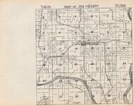
How can I determine what the section number is?
Each section number is clearly marked on the township page in the center of each section (see illustration below).
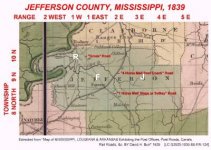
What are tier and range numbers?
These numbers represent Township and Range and are indicated at the top of each Township page (see illustration below).
Most townships have one section that was donated to the school.Usually dead center in the 36 section parcels. Many of these are no longer a school,but actually the site of a former one.....these are a great place to find and search.
One section = 1 square mile = 640 acres. Townships vary but sections are constant. Sections are further divided into halves, quarters, halves of quarters (eighths) and so on. The “west half of the north east quarter” defines an 80-acre tract, 1/4 mile east-to-west by 1/2 mile north-to-south.
How can I determine what the section number is?
Each section number is clearly marked on the township page in the center of each section (see illustration below).
What are tier and range numbers?
These numbers represent Township and Range and are indicated at the top of each Township page (see illustration below).
Most townships have one section that was donated to the school.Usually dead center in the 36 section parcels. Many of these are no longer a school,but actually the site of a former one.....these are a great place to find and search.


")