WIDirtFishing
Sr. Member
- Apr 29, 2010
- 322
- 129
- Detector(s) used
-
Minelab Equinox 800
Past:
Tesoro Tiger Shark
Tesoro Silver uMax
AT Pro
- Primary Interest:
- Metal Detecting
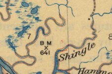
Was wondering if anyone could help me out with this topo symbol. Not sure what it means and was hoping some pros here could throw me a bone.
It is a map from the 30's and the same symbol appears 3 times on a large map in different spots
It is a map from the 30's and the same symbol appears 3 times on a large map in different spots


Attachments
Upvote
0

