Maps and Overlays for Metal Detecting

Nugs Bunny

Hero Member
Mar 13, 2013
515
491
Ohio
Detector(s) used
White's MXT Pro
Primary Interest:
All Treasure Hunting
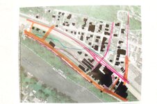
I just thought I would share my technique of combining old maps and current maps using celluloid overlays.

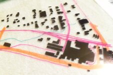
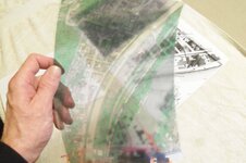
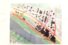
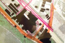
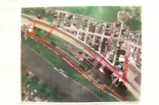
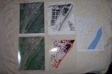
After resizing them to the same scale I printed them off. Then using an overhead projector I lined up the streets and marked the features from the old map onto the current one. Using that as a master I then copied the old map onto celluloid.

Now everything lines up perfectly and I know where to search. I plan on recording the location and depth of my finds on a separate celluloid overlay. By recording the location of my finds with GPS I hope to gain better knowledge of the area.

This is a technique I have adapted from prospecting, I used this technique to create overlays of geological maps, watersheds and counties to pinpoint areas of interest.

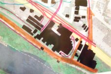
1888 map showing structures and Google Map images. The two at the bottom in the first picture are celluloid the other pictures show the use of the different overlays.
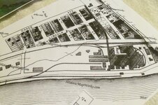
100_7479.JPG 100_7480.JPG 100_7483.JPG
100_7486.JPG 100_7489.JPG 100_7490.JPG
100_7491.JPG 100_7492.JPG 100_7493.JPG
100_7494.JPG
 

Upvote 0

danloop

Full Member
Feb 16, 2014
195
198
Kentucky
Detector(s) used
Unicorn Treasure Master Pro
Modes:
Dowsing
Pulse Induction
Multi-Frequency
Ground Penetrating Radar
Beat Frequency Oscillation
Aural Target Identification
Primary Interest:
Metal Detecting
I used a similar method (without printing) to identify an old home no longer on the property. Despite that, never got a single beep.
 

Digging Deeper

Full Member
Jan 12, 2013
103
56
Mississippi Gulf Ciast
Detector(s) used
Whites V3i D2 & 5.3
Garrett AT Pro stock
Bounty Hunter 505
Cheap UW PI
Whites TRX
Garrett Pro pointer
Vibra-Quatic 2
I have done the same using historic ariels site. All electronic though. It worked out well a few times.
 

OP
OP
Nugs Bunny

Nugs Bunny

Hero Member
Mar 13, 2013
515
491
Ohio
Detector(s) used
White's MXT Pro
Primary Interest:
All Treasure Hunting
I have done the same using historic ariels site. All electronic though. It worked out well a few times.


I had a problem with ariels with maps for this area, they didn't line up properly using the overlay. Also the oldest map they has was 1926, I'm not saying it's not a good site to use, I still do. But for these series of maps I had to go old school and do a little by hand. Now I can scan them and make as many different versions as I like digitally.
 

OP
OP
Nugs Bunny

Nugs Bunny

Hero Member
Mar 13, 2013
515
491
Ohio
Detector(s) used
White's MXT Pro
Primary Interest:
All Treasure Hunting
How do you find old maps of areas?

Besides the sites already mentioned they have old maps at the Library of Congress and in old atlases at other libraries. There are many map collections out there so one just has to search.
 

eze1417

Greenie
Jan 1, 2014
11
7
West Alexander
Detector(s) used
Legacy 3500 with Super-Scan
Primary Interest:
All Treasure Hunting
How do you find old maps of areas?

I use the USGS website and research the old topography maps. Most of these maps show home locations but older may not show sub structures such as barns and outbuildings. One thing to remember with USGS maps is this, quandrants changed after WWI to give more detail. Other things to consider are some USGS maps are no longer on archive and are missing. I have also found going to your local courthouse and hitting up the deeds room can help with mapping out a particular property. Most older deeds on file or microfilm will state where certain structures, burial plots, and utilities were located. I have come across many finds this way.


USGS website: [The National Map: Historical Topographic Map Collection
 

Jason in Enid

Gold Member
Oct 10, 2009
9,593
9,229
Primary Interest:
All Treasure Hunting
You can do the same with map overlays in google-earth. Plus you can have the benefit of seeing the old map over current satellite imagery or road map. Just another tool to keep in the tool box!
 

OP
OP
Nugs Bunny

Nugs Bunny

Hero Member
Mar 13, 2013
515
491
Ohio
Detector(s) used
White's MXT Pro
Primary Interest:
All Treasure Hunting
The problem I ran into for this specific location was a lack of older maps, I use all the maps sites that have been listed and a few others that haven't.

The hill behind my house is an abandoned iron mine, the buildings by the river was the steel mill, as one of the biggest employers in town at the time a lot of the homes were built to house the mine workers.

All the buildings on that old map are gone along with some of the streets, the houses are the only thing remaining. Bob Evans restaurant sits where the main building used to stand, they just built an urgent care next to BE and covered more of the old site in the process. North of Bob Evans and East to the river are about the only areas left to search, there were some structures due south that I suspect were homes.
 

villagenut

Gold Member
Oct 18, 2014
5,761
10,258
florida
Primary Interest:
All Treasure Hunting
In my book(not yet published) about my towns history in connection with artifact recoveries by myself, I have used this same trick and the images are quite on the money as to old landmarks that are still there and those not. I showed these pages of mine to an archaeologist acquaintance of mine and he had never thought of doing such a thing but thought it would be useful in doing his own field studies of the area.He never thought of doing this....go figure.
 

Top Member Reactions

Users who are viewing this thread

Latest Discussions

Top