TrpnBils
Hero Member
Yes, I know there are programs that will overlay things like this, but I have had zero luck in using them successfully:
I have an old map from 1876 that has no scale to it, but seems to be pretty well drawn. Finding lost sites seems difficult in this case because so many of the roads have changed over the years. In my case of trying to find a school, the roads on Google Earth have changed so much from the old map that there's really no useful way to just eyeball it. What I do is the following -
1) Locate two known points on the old map that are still able to be found on Google Earth with a high degree of certainty. I use intersections, but I know a lot of people use streams. They change too much for my liking over the time periods I'm talking about, so I ignore them.
2) On the old map, measure distances between the two known points. It won't be an actual distance, but rather just a distance apart on the maps. I like to use millimeters. Write this down.
3) Measure from one known point to the unknown location (in my case, a school) and write that measurement down. Calculate the ratio of this distance to the first (a ratio of 1.25, for example, will mean the distance to the unknown location is 1.25 the ACTUAL distance between the two known points).
4) Repeat the last step with the second known point to the unknown location.
5) On Google Earth, measure the distance between the two known points (using the measuring tool, of course) and make a note of it.
6) Multiply this distance by the two ratios calculated in steps 3 and 4.
7) Starting at one of the known points, use the circle measuring tool on Earth to measure out a circle whose radius is equal to the distances calculated in Step 6. Using the circle tool makes knowing the angles unnecessary between the known and unknown points.
8) Repeat Step 7 with the other point and the other ratio.
Where the circles cross (you will have to save them after you draw them, but they get put in the Temporary Files folder and will go away on their own when you close the program) should be just about right on your site if you were careful.
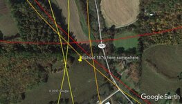
Here is an example of what you end up with. I did this from three sets of points (each set of red, orange, or yellow circles indicates a different trial) just for my own curiosity and ended up with three different intersecting points, and the school should be in there somewhere. This left me with a search area of about 0.01 square miles, which is totally doable. I eyeballed this location before trying to triangulate it and I would have been off by about half a mile if I would have just gone with my gut!
I have an old map from 1876 that has no scale to it, but seems to be pretty well drawn. Finding lost sites seems difficult in this case because so many of the roads have changed over the years. In my case of trying to find a school, the roads on Google Earth have changed so much from the old map that there's really no useful way to just eyeball it. What I do is the following -
1) Locate two known points on the old map that are still able to be found on Google Earth with a high degree of certainty. I use intersections, but I know a lot of people use streams. They change too much for my liking over the time periods I'm talking about, so I ignore them.
2) On the old map, measure distances between the two known points. It won't be an actual distance, but rather just a distance apart on the maps. I like to use millimeters. Write this down.
3) Measure from one known point to the unknown location (in my case, a school) and write that measurement down. Calculate the ratio of this distance to the first (a ratio of 1.25, for example, will mean the distance to the unknown location is 1.25 the ACTUAL distance between the two known points).
4) Repeat the last step with the second known point to the unknown location.
5) On Google Earth, measure the distance between the two known points (using the measuring tool, of course) and make a note of it.
6) Multiply this distance by the two ratios calculated in steps 3 and 4.
7) Starting at one of the known points, use the circle measuring tool on Earth to measure out a circle whose radius is equal to the distances calculated in Step 6. Using the circle tool makes knowing the angles unnecessary between the known and unknown points.
8) Repeat Step 7 with the other point and the other ratio.
Where the circles cross (you will have to save them after you draw them, but they get put in the Temporary Files folder and will go away on their own when you close the program) should be just about right on your site if you were careful.
Here is an example of what you end up with. I did this from three sets of points (each set of red, orange, or yellow circles indicates a different trial) just for my own curiosity and ended up with three different intersecting points, and the school should be in there somewhere. This left me with a search area of about 0.01 square miles, which is totally doable. I eyeballed this location before trying to triangulate it and I would have been off by about half a mile if I would have just gone with my gut!


Attachments
Upvote
0

