Lidar maps?

Shane508

Jr. Member
Sep 19, 2017
64
91
Massachusetts
Detector(s) used
Garrett Ace 350, Bounty Hunter Tracker IV
Primary Interest:
All Treasure Hunting
So I went on a hunt today with a bunch of people. We met at a guy's house beforehand, who showed us where we were going by using a map on his phone. He then switched the type of map to a neat version that eliminated everything except the ground, and you could see the cellar holes perfectly. I asked him what app he was using, and of course, he wouldn't share it. Someone else told me that type of map is called Lidar.

Been looking for an app, but coming up short. Anyone hear of it or know where I can find this mystery app?
 

Upvote 0

Simon1

Gold Member
Jun 11, 2015
12,194
56,930
Primary Interest:
Other
An app doing this could be handy but I haven't heard of one yet . Could be wrong. Lidar works on the principle of radar, but uses light emitted from a laser. I am not aware of cell phones using lasers, ( yet ).
 

MadTom

Sr. Member
Dec 6, 2016
299
334
Vermont
Detector(s) used
Bandido umax
Primary Interest:
All Treasure Hunting
Some states have there own lidar maps online. He may if just downloaded some. Vermont has most of the state covered but I’m having a hard time getting at them because I have a Mac and they need a Microsoft program. Check your States mapping division
 

Loco-Digger

Gold Member
Jun 16, 2014
11,827
17,744
Northern O-H-I-O
🥇 Banner finds
1
Detector(s) used
F75 LTD, 1280X Aquanaut, & a Patriot (back-up/loaner)
Primary Interest:
Metal Detecting
Just google lidar, I bet you'll be drooling over some of the pics showing parts of England. It's what I call MD porn. :tongue3:
 

WaterScoop

Bronze Member
Sep 12, 2017
2,181
3,710
SW Washington
Detector(s) used
Nox 800,
CTX 3030,
XP DEUS,
Excalibur II
Garrett AT Max,
Whites DFX,
Vanquish 540
Primary Interest:
All Treasure Hunting
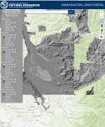
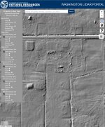
We have it in Washington and its Free online

Here is a screenshot of my area, the level of detail once you zoom in Is crazy

You can superimpose over google maps and get the streets perfectly lined up.

CBADB15E-7AC1-45C7-A4AA-D5D61902B62F.jpeg 7FCE1368-D36B-4300-8311-C979093D86C5.jpeg

Cheers

042DA115-E479-4149-AED7-CAE87427438B.jpeg
 

OP
OP
S

Shane508

Jr. Member
Sep 19, 2017
64
91
Massachusetts
Detector(s) used
Garrett Ace 350, Bounty Hunter Tracker IV
Primary Interest:
All Treasure Hunting
I managed to find something provided by my state's website, but it's ridiculously confusing. You have to install an app, go to another app, extract data, save it to an excel doc, copy the link, put it into the app you installed, then put it into a map.. I work with computers, in and out of work, and even I cannot understand how to do it lol.
 

WaterScoop

Bronze Member
Sep 12, 2017
2,181
3,710
SW Washington
Detector(s) used
Nox 800,
CTX 3030,
XP DEUS,
Excalibur II
Garrett AT Max,
Whites DFX,
Vanquish 540
Primary Interest:
All Treasure Hunting
I think I'll wait for the movie.
Some states make it easy others you have to jump through fiery hoops nevertheless they are all additional tools that help you locate those “virgins” ....sites that is. Getting a head start on a site is the difference between good targets and GREAT targets.

0BD1ABE1-1BD5-4B8E-9D52-3AFFBFC21B50.jpeg
 

Eleven Cents

Full Member
Nov 30, 2016
169
309
Tucson, AZ
Detector(s) used
Tesoro Vaquero
Primary Interest:
Metal Detecting
The USGS provides lidar point clouds for the whole US. The trouble is getting it into a usable format.
 

MadTom

Sr. Member
Dec 6, 2016
299
334
Vermont
Detector(s) used
Bandido umax
Primary Interest:
All Treasure Hunting
I managed to find something provided by my state's website, but it's ridiculously confusing. You have to install an app, go to another app, extract data, save it to an excel doc, copy the link, put it into the app you installed, then put it into a map.. I work with computers, in and out of work, and even I cannot understand how to do it lol.

Vermont’s is Terrible, like most if their websites
 

Top Member Reactions

Users who are viewing this thread

Top