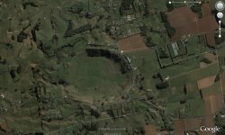
Where to hunt around a crater for metorites??? Crater Picture Updated!!

sasnz

Sr. Member
Aug 15, 2006
429
29
Auckland
Detector(s) used
Garrett 2500 GTI
Hi

This might sound like a dumb question, but if you have what you suspect to be a large crator, where would be the best place to find any reminants of a metorite. I am thinking the middle but the more i have read the edges seem to produce better results. I dont have a good understanding of how the metorite would desindergrate after impact. I am thinking anything in the middle would be pretty deep.

Can anyone share some light on this or offer some good advice. I am happy to PM anyone some cordinates of a site that i am looking at.

I have measured the photo below, its diameter is approx 1.1km across all around. I am guessing from memory but the floor of this impression would be approx 60-100metres deep.

cheers Sasnz
 

Attachments

  • crater.jpg
    crater.jpg
    233 KB · Views: 1,065

Galactic-Stone

Jr. Member
Mar 12, 2009
29
2
Florida
Detector(s) used
Tesoro Compadre
Hi Sasnz!

It's not a dumb question, it's a very valid question. :)

People are using Google Earth to find new impact structures frequently nowadays. It's a rare opportunity for the layman to contribute to serious science. The data is out there in the form of high resolution satellite photos, and anyone can access it.

At first glance, I don't think the area in the photo is an impact structure. It does have some features that suggest an impact structure, but the lack of central uplift is telling. Of course, not all impact structures have a noticeable central uplift, but the lack of one combined with the squashed almost tear-drop shape of the depression suggests either a terrestrial sinkhole or subsidence zone, or if it's an impact, it's a rare oblique impact scar which is very unlikely.

There are many terrestrial geological processes that produce unusual formations or apparent scars on the Earth's surface - in fact, the reality of impact craters was not widely accepted in the scientific community until the middle 20th century. Some holdouts refused to accept that rocks from space hit the Earth. If Barringer had a dollar for every time someone told him that the Canyon Diablo impact crater was volcanic in origin, he wouldn't have gone broke. ;)

The Meteoritical Society maintains a database of all known meteorite finds and impact structures, you can search to see if this structure is already documented - http://tin.er.usgs.gov/meteor/metbull.php

Check the "place" box on the left hand side of the form, and type your state into the query field. If there are any known craters in your area, it will show up in the database. If it's not in the database, it's not a crater, or it's brand new discovery(!) - the latter of which has been happening a lot lately.

Best regards,

MikeG
 

OP
OP
sasnz

sasnz

Sr. Member
Aug 15, 2006
429
29
Auckland
Detector(s) used
Garrett 2500 GTI
Galactic-Stone said:
Hi Sasnz!

It's not a dumb question, it's a very valid question. :)

People are using Google Earth to find new impact structures frequently nowadays. It's a rare opportunity for the layman to contribute to serious science. The data is out there in the form of high resolution satellite photos, and anyone can access it.

At first glance, I don't think the area in the photo is an impact structure. It does have some features that suggest an impact structure, but the lack of central uplift is telling. Of course, not all impact structures have a noticeable central uplift, but the lack of one combined with the squashed almost tear-drop shape of the depression suggests either a terrestrial sinkhole or subsidence zone, or if it's an impact, it's a rare oblique impact scar which is very unlikely.

There are many terrestrial geological processes that produce unusual formations or apparent scars on the Earth's surface - in fact, the reality of impact craters was not widely accepted in the scientific community until the middle 20th century. Some holdouts refused to accept that rocks from space hit the Earth. If Barringer had a dollar for every time someone told him that the Canyon Diablo impact crater was volcanic in origin, he wouldn't have gone broke. ;)

The Meteoritical Society maintains a database of all known meteorite finds and impact structures, you can search to see if this structure is already documented - http://tin.er.usgs.gov/meteor/metbull.php

Check the "place" box on the left hand side of the form, and type your state into the query field. If there are any known craters in your area, it will show up in the database. If it's not in the database, it's not a crater, or it's brand new discovery(!) - the latter of which has been happening a lot lately.

Best regards,

MikeG

Hi Mike,

Thanks for your reply, What do you mean by the term "Central Uplift" not quite got the jist of that one. Also if this was a impact crater(not saying it is) where would you normally find the bits of meteor.

Regards Glenn
 

Tuberale

Gold Member
May 12, 2010
5,775
3,446
Portland, Oregon
Detector(s) used
White's Coinmaster Pro
sasnz said:
Hi

This might sound like a dumb question, but if you have what you suspect to be a large crator, where would be the best place to find any reminants of a metorite. I am thinking the middle but the more i have read the edges seem to produce better results. I dont have a good understanding of how the metorite would desindergrate after impact. I am thinking anything in the middle would be pretty deep.

Can anyone share some light on this or offer some good advice. I am happy to PM anyone some cordinates of a site that i am looking at.

I have measured the photo below, its diameter is approx 1.1km across all around. I am guessing from memory but the floor of this impression would be approx 60-100metres deep.

cheers Sasnz
Looks possible to me. Would be a relatively rare oblique crater as stated elsewhere in this thread. To my eye, looks like a multiple strike location. I can see at least 3 closely associated strikes.

Where would you find pieces? To the right of the strike(s) in the photo. Assuming a shallow angle of impact, and all craters from the same fall (single meteoritical occurence, but multiple strikes) pieces could be scattered 20-30 km away or more.

Assume photo from New Zealand, which is noted for its volcanic activity. Apparent craters could have volcanic origin, too. You'd need a stereoscopic image of the site to be more certain, and even then you'd have to find pieces of tektites or meteorites for confirmation.

Thanks for posting.
 

cratergeek

Newbie
Nov 21, 2011
1
0
Primary Interest:
Prospecting
I think this is a nice example of a possible maar crater partly because of the inner rim I see that may be a ring fault. Investigating this ring fault for what rock type it consists of would be an easy first move on answering the question of what type of crater this in fact is. I have noticed that here in the U.S. significant land forms such as what you present here, are almost alway on a geologic map somewhere. If this is a maar crater it would be almost certain that others are nearby. Often kimberlites are present where maars erupt, so this could be just as exciting as any impact crater. As for meteorites or rather where they might remain after impact, check out Meteor Crater for some good information on the many finds in Canyon Diablo and vicinity from this famous impact. This could be an impact crater of course, I would be interested in its location to scan for other possible diatreme (maar) locations as they almost always cluster or appear as nested diatremes. Maars are the surface expression of a diatreme, we have many fine examples of this type of crater in the U.S. in Arizona and Oregon. Nice find. Good Luck.

Michael
 

Tuberale

Gold Member
May 12, 2010
5,775
3,446
Portland, Oregon
Detector(s) used
White's Coinmaster Pro
Thanks for posting, Michael! And welcome to TNet!

Kimberlite? Some exciting possibilities there.
 

stylin88

Newbie
Apr 27, 2011
3
1
Tuberale said:
Thanks for posting, Michael! And welcome to TNet!

Kimberlite? Some exciting possibilities there.
would like to know what you think of this

43 deg 11"24.12"N
115 deg 24"12.01"W

boise state university is going in this spring to ck it out.
ive been there and its a hit for sure but real old. google map just dont do it justice
 

Top Member Reactions

Users who are viewing this thread

Latest Discussions

Top