Places In Southern MN That May Hold Interest

C

colmn

Guest
It is said that there is a box containing gold, coins & cash buried on the north side of the Minnesota river in Judson MN area. It is supposed to be buried in a meadow area in the middle of 5 giant oak trees that grow next to a creek. The cache supposedly is stashed there by Jesse James while evading a posse after one of his robberies. Rex McBeth spoke of this before he passed on. He and others had done some hunting for the site. A guy "Jim Anderson maybe ? don't remember name, it's been many years ago but do remember that the guy was always @ the library or in schools telling stories about old days. Guess he was one of he first to canoe down the MN river to the Mississippi and then to the gulf" that lives in the Judson area also spoke of this. When going N. out of Judson, just across the river bridge, that is the area "somewhere between the river and the hillside". This area does have allot of Indian history also. The guy that has the house directly on the right hand side of the bridge had to wait during constructing the home "many years ago" as when they were digging the foundation, they dug up Indian artifacts.

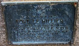
Another interesting spot to explore & detect would be in an area just south of Mankato at the site where the old Fort used to be. This area had a great deal of bloodshed during the Sioux uprising. This area is also where most of the Sioux that were hung in the mass hanging @ Mankato were caught at. I've wandered out that way a few times with my kids but have only found sections of broken pottery. Never with M/D thou.

The Jones Ford river crossing is also in the area S. of Mankato. A great deal of wagon traffic passed through there for points south and west.
 

Wetgreenie

Hero Member
Oct 14, 2005
871
6
Central Minnesota
Detector(s) used
GTI 1500, Tesoro Silver U max
That is awesome! I was just in Mankato for the first time a week or so ago.
I thought it might be a good place to hunt. It seems to just Ooze history.

Is the old fort a protected site like a state park or just county land now?
It sounds like a place to go........maybe not in the dark though.......
 

OP
OP
C

colmn

Guest
Since I made that post I did a lil research. It had been told that the old fort "Ft. Lincoln" was aprox 5 miles south of Mankato. In present day that would place it in the area of the Red Jacket Bridge on the S. side of the Blue Earth River. Town elders also state that that area is where the Ft. was at. Now . . . last week when doing some "google" fact finding, I found "shoulda saved the sources" some info stating that the Ft. is where the present day Sibley Park is located in Mankato "Sibley Park is where the Blue Earth River drains into the MN River". Which would place the Ft. directly in Mankato itself. My thought is that if the Ft. was in the park, they would of preseverd it.

There is an area of private land out there that is fenced off. It is my feeling that that private land is where the Ft. was located. There is also a Historic Marker out there on land that is owned by a gravel pit company. "Now that I'm thinking about it I am going to go there right now and take some photos and read that marker as I have never read it before." I will post them in this fourm when I get back.

ALSO . . . The land in west sibley park "known as land of memories park" is localy called Arrowhead Island. This spot was to be where there was a Sioux camp back in the day. My dad said when he was a kid that he and his buddies used to go there to find arrowheads. The local library has a display with a good deal of artifacts from there "as well as other close by areas".
 

OP
OP
C

colmn

Guest
Another item added into the mix. I wwent out to check out the historic marker. Yes, it denotes the site of a Ft. BUT. . . the Ft. it is talking about is Ft. Lehillier, not Ft. Lincoln. I'm still under the impression that Ft. Lincoln was out close to the Red Jacket bridge. In all. . . I think the area just south of Mankato could be very interesting hunting grounds.

Ft. Lehillier was built in 1700 by a french fur trader, Pierre Charles Le Sueur. They spent one winter there. Below is photo of the plaque. The 1926 date on the plaque is there as this was the date the marker was erected. Like mentioned in the other post above, there is a fence in the treeline just above the marker and a few homes inside the fence on the hillside. This area is very close to the Blue Earth River "100 +/- yards". The plaque faces a hillside, but there is a vast open meadow which I think the Ft. was located on. I think they may have placed the plaque there as so it can be close to the roadway. I will be contacting the property owners to see about options on hunting this meadow and the water line close to the river. It could hold interesting hunting as the river is very low. I'm not sure if / how much hunting has been done here but can say that this seams to be a somewhat of a hidden gem "so to speak".
 

Attachments

  • FtLeHillier.jpg
    FtLeHillier.jpg
    53.2 KB · Views: 2,463

dfxdude

Full Member
Jun 29, 2004
208
35
Wilmont, MN
Detector(s) used
White's DFX (2) V3i(1)
Primary Interest:
All Treasure Hunting
Here are some towns listed as Ghost Towns in Mankato area (Blue Earth and Nicollet Counties). The reference is 20 years old......United States Treasure Atlas Volume 5.
Blue Earth County:
1. GT Cambria on RR and Minnesota River, 3 miles SE Courtland
2. GT Judson on RR 9 miles NW Skyline
3. GT Butternut 7 1/2 miles NE Madelia
4. GT Rapidan 4 mi SW Skyline
5. GT Smiths Mill on RR, 3 miles NW Janesville
6. GT Garden City 13 miles due E of Madelia
7. GT Beauford 5 miles N of Mapleton
8. GT Willow Creek 5 1/2 miles W of Amboy

Nicollet County
1. GT Bernadotte 4 mi E of Lafayette
2. GT St. George 8 miles SW Lafayette
3. GT Klossner 6 miles SSW Lafayette
4. GT New Sweden 11 miles due S Gaylord
5. GT Norseland 10 miles NW of St. Peter
6. GT Traverse 3 mils NW of St Peter
7. GT Oshawa 5 1/2 ENE of Nicollet
8. GT North Star 5 miles due W of Kasota
 

dfxdude

Full Member
Jun 29, 2004
208
35
Wilmont, MN
Detector(s) used
White's DFX (2) V3i(1)
Primary Interest:
All Treasure Hunting
Here's an anecdote for Olmstead County that I found in the U.S. Treasure Atlas.

During the early 1930's, the notorious "Ma" Barker and Alvin Karpis gang obtained a $100,000 ransom demand for the kidnapped owner of the Hamm's Brewery in St. Paul. Having such an easy time at obtaining the mney, they thn kidnapped Edward Bremer, president of a St. Paul bank. Receiving a $200,000 ransom for him, the gang pushed him out of their car while making their escape just N of Rochester. Somewhere between Chatfield and Rochester, a 10 miles stretch along old State Hwy 52, they pulled off the road and buried half of the currency, $150,000 in $5 and $10 bills, under a fence post in a canvas-wrapped metal box. The gangsters were gunned down in a shootout at one of their hideouts in Florida sometime later and the cache of currency was never recovered.

Sounds like this is down in your bailiwick, BK.
 

bk

Bronze Member
Jan 19, 2005
1,423
65
SE Minnesota
Detector(s) used
Minelab Explorer SE pro, Minelab Explorer XS, Garrett Freedom II (3), Garrett pro-pointer.
Primary Interest:
Metal Detecting
Our detecting club was invited to detect the remains of a fort near Cosmos, MN a few years ago. The fort was called "Fort Pipe Lake". It is on private property and was known to exist but no one knew where. The property owner discovered it in a wooded area on his property shortly after purchasing the land.
He purchased a detector and found a few items but wanted some help from someone with more detecting experience.
Our club was contacted and invited to spend the day there. Lots of artifacts were found including a carved bullet with the date 1863 on it. Also found was a brass name plate of a person who was stationed there during the period of occupancy (1863). All the finds were given to the property owner who put them on display in the Meeker County Historical Society.
The site is now on the National Register of Historic Places.
Here is a link to the site.http://www.google.com/url?sa=U&start=18&q=http://www.state.mn.us/ebranch/admin/historic_fort.html&e=9797&sig=__H4-cL_tKdVX0HXKFyntIyr8614E=
 

OP
OP
C

colmn

Guest
Had a nature moment just now. . . there were about 20 turkeys out in the yard across the street.
Any hoot. . . . Thos ghost towns are interesting indeed. Some of those still are active towns.
I was just speaking with my dad and mentioned the interest in the area south of town "Mankato". He was telling me that when he was a kid here in town, it was told of a great amount of gold that the inidans had hid in the hills south of Mankato along the Blue Earth River. This event was to have happened before the river had changed it course during the 1800's. It is said that many have looked with no luck as people were searching along the rivers present day course.
Sounds like some research for tomorrow.

Rainy Lake MN. This is the home to MN's only load gold mine. It's waaaaaaaaaaaaaaaay up north in the woods. In the past, I had done research on gold in MN and found that there was a pretty good gold rush up to the Rainy Lake, Lake Vermilion area. I have some info posted on my family fun site here http://www2.69cents.com/lon/ClubMNGoldRush.htm about mn gold, mn gold rush and mn diamonds. "that site has had no updates for a long time but the info is valid and can be crossed referenced across the internet".
 

Blackjack77

Hero Member
Jun 16, 2006
599
14
Minnesota
I've heard about the "Ma" Barker cache- its on a CD about Treasure in the five state area. I'll look at it again and
include any more info about that cache. I also noticed a while back about a treasure club based out of Duluth with emphasis on Gold hunting- -link hadn't been updated in quite a while. I'll check that out later also.
I think our whole state has many good possibilities yet,just have to find them!! A friend of mine has a site
we need to find time to detect- used to be a Rural "party" spot. I think that would mean more of dance hall variety, not high school "kegger" type!!
Lots of good info between everyone-- very interesting!!
Thanks
Tim

Time is running out for 2006!! Good luck to all!!
 

Wetgreenie

Hero Member
Oct 14, 2005
871
6
Central Minnesota
Detector(s) used
GTI 1500, Tesoro Silver U max
with the Ma Barker Cashe
I tought it might be cool to mount a two box detector to my ATV and go ride some of those ditches.
We could collabrtate and call it a club hunt.


It would be too cool to get to mankato with Colmn. Just like I had suspected,
it may be a great time to hit the river edges.
 

dfxdude

Full Member
Jun 29, 2004
208
35
Wilmont, MN
Detector(s) used
White's DFX (2) V3i(1)
Primary Interest:
All Treasure Hunting
There's a story regarding WABASHA county in the US TREASURE ATLAS that reads:
656A. Lake City, on the Mississippi River and Lake Pepin, hold secrets to several treasure caches
hidden by bootleggers during the days of Prohibition and by wealthy farmers and businessmen.

656B. A treasure hunter from Rochester uncovered 3 different treasure caches in Lake City.

Was that you BK ? ? ? ?
 

wolfpaw518

Full Member
Oct 15, 2006
119
0
Minnesota
Detector(s) used
Sharpshooter II
Years ago when I was NEW at this, I went to a local museum and found a book on the Dakota conflict, it was written not long after the event, and had a lot of good information about a Fort Ridgley in southern MN, so with maps and info in hand off I went. This Fort is now a State Park, so after paying my fee I mentioned to the young volunteer manning the desk of my intentions. After a couple of hours of searching an area out in the trees and finding nothing but junk ( I was new remember) I gave up and returned to the front office...wanna take a guess who was waiting for me? YEP! Mr. Ranger, who was nice enough to come out and meet me! >:(

He was cool..wanted to know if I found anything, I said "yep" and handed him a paper bag full of pop cans, pulltabs (they ARE everywhere) and other assorted rusty garbage...he smiled and informed me about what I had just done. I wasn't in trouble though, after all I DID mention it when I came in, and was not stopped and not finding anything helped. We went in and had a nice chat about the place and it's history, I left feeling good and a LOT wiser.

I've learned a lot more sense then...

neil.
 

OP
OP
C

colmn

Guest
Still waiting on the knuckle head to get back with me about the ft. lehillier site. Getting kinda late in the year now. Looks like their could be 3 inches of snow on the ground by tomorrow evening here as per the forecast.
 

BioProfessor

Silver Member
Apr 6, 2007
2,917
84
Mankato, MN
Detector(s) used
Minelab e-Trac, White E-Series DFX
I researched the fort on the Blue Earth river. Pretty easy to find. There is a subdivision built on top of where it was. Just drive down River Fort Drive southeast of Mankato. Seems like others had the same idea and researched the fort. There are "No Trespassing" signs everywhere. Oh well. One more site off the map, down the drain, covered over.

Daryl
 

OP
OP
C

colmn

Guest
The fort is on the hillside behind gates and fences. When standing at the marker 'shown in above photo from another post I made' if you look to the right, there is a giant grass meadow between the road and the hillside that runs / intersects with the river. This area is considered 'under management of park dept' and pubic land. This would be the area I'm interested in detecting as it would have been there that any fight would have taken place 'prior to storming the ft. that is'. After SEVERAL attempts to contact the head of the county park dept, the jerk will not return my calls. Boy am I glad I pay taxes to pay this guys income. Many go to the Ft. itself, see it's locked up, and leave. No one takes a gander at the open grassy area. This area should have some finds. As well . . . I'm sure the river there will also hold some type of finds.

As for the cache they buried. . . I don't think the property owner is going to find it on the Ft. site. They took it off site to hide it 'which only makes sense'. The old route of the river in the hills just to the south of there should hold the key in finding this bounty.
 

dfxdude

Full Member
Jun 29, 2004
208
35
Wilmont, MN
Detector(s) used
White's DFX (2) V3i(1)
Primary Interest:
All Treasure Hunting
Reference: United States Treasure Atlas Volume 5 (1985)
GT = Ghost Town, RR= Railroad
The following are in WINONA COUNTY.

GT: Beaver, 9 mi E of Plainview
GT: Bethany, 7 mi W Stockton
GT: Homer, on RR, 5 mi SE Winona
GT: LaMoille, on RR, 10 mi SE Winona
GT: Pickwick, 2 mi SW of GT LaMoille
GT: Fremont, 5 mi. SSW Lewiston
GT: Wyattville, 8 1/2 mi N of Rushford
GT: Wilson, 6 mi S of Winona
GT: Centerville, 15 mi W of Dakota
GT: Witoka, 14 mi W of Dakota
GT: Ridgeway, 11 mi W of Dakota
GT: Hart 4 mi N of Rushford
GT: Nodine, 4 mi W of Dakota
GT: New Hartford, 7 mi WSW Dakota
GT: Dresbach, on RR, 1 mi SE of Dakota
 

dfxdude

Full Member
Jun 29, 2004
208
35
Wilmont, MN
Detector(s) used
White's DFX (2) V3i(1)
Primary Interest:
All Treasure Hunting
Rushmore98:
If you want to go across the river to Buffalo County, Wisconsin and with a little research you might find some interesting locations. There are 15 Ghost Towns listed and only 6 of them can be located on today's maps.
Here are the ones that are still on present day atlas.

GT: Misha Mokwa, 3 mi NE of Nelson
GT: Trevine on W county line, 3 1/2 mi W of Nelson
GT: Praag, 3 mi N of Cream
GT: Montana, 3 mi NNE Waumandee.
GT: Herold, 2 1/2 mi E of Alma
GT: Marshland on SE county line, 5 mi W of Centerville.

Those listed that I couldn't locate on present day atlas.
GT: Savoy on W County Line, 2 mi SW of Maxville
GT: Norden on NE county line, 5 mi N of Lookout.
GT: Whelan, 4 mi S of Gilmanton.
GT: Regli, 6 mi NNE Waumandee
GT: Theisen on E county line, 7 mi NE of Independence
GT: Anchorage 2 1/2 mi S of Cream.
GT: Glencoe on E county line, 3 mi WNW of Arcadia
GT: Kinley 5 mi W Arcadia

A visit to the Buffalo County Historical Society (located at Alma) might give some insight to these locations.
 

dfxdude

Full Member
Jun 29, 2004
208
35
Wilmont, MN
Detector(s) used
White's DFX (2) V3i(1)
Primary Interest:
All Treasure Hunting
Hey, Shirl (Melnatcat) here are some tips for Morrison County.

GT: Lincoln on County Line and RR, 8 mi S. of Motley
Hwy 10 & Lincoln Beach Road
GT: Cushing on Hwy 10 and RR at 260th St, 6 mi NW of Randall
GT: Darling Switch, on RR 5 mi SE of Randall. Hwy 10 and Eva Lane
GT: Freedhem 7 1/2 mi W. of Lastrup 203rd St at Jewel Road
GT: Gregory on RR, 2 1/2 mi SE Little Falls. Hwy 10 & 123rd St.
GT: North Prairie 2 1/2 mi SE of Bowlus, 150th St & Great River Rd.
GT: Little Rock 4 1/2 mi S of Buckman, Hwy 25 and Nature Road
GT: Morrill 16 1/2 mi E of Royalton, 330th St and Nature Road
GT: Ramey 2 mi E. of GT Morrill, 345th St and Nature Road
FT: Fort Ripley aka Fort Gaines, on the W bank of the Mississippi
River. 7 mi above mouth of Crow Wing River and opposite the mouth
of the Nokay River near the town of Fort Ripley. In use from 1849-1877
GT: Camp Ripley Junction 7 mi S. of Fort Ripley. Intersection of
Hwy 371 & Hwy 115 and 213th St.
 

Top Member Reactions

Users who are viewing this thread

Top