Ray S S
Silver Member
We have had a lot of rain lately and heavy torrential rain during the weekand. Monday while
I was out for an early bike ride on the bike trail that runs close to our house, I came upon
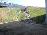
a bad situation. The trail runs under the I69 Freeway. Between the two bridges there was a pile
of sand that washed down the hill from the top next to the road. It has been washing out in very
small ammounts since last summer, but not enouch to mention. I have been on it several times
this spring and it was the same as last summer. monday was the first time in about four days.
I had my camera with me so I took some pics. When I got home I called the highway dept. to
warn them to go out and inspect it because it is bad enough now to need imediate attention or
the bridge will be in danger.
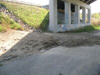
#1...shows the sand washed down on the trail
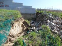
#2...looks up the hill to see where it is from and how the rocks that were supposed to stop
washouts have been undermined and caved in
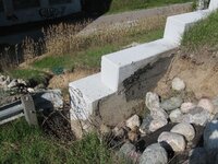
#4...Standing at the wingwall facing the road, this shows how it is undermining the paved shoulder.
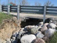
#5...shows how wide spread out and how deep it is.
When I was there this afternoon, it didn't look like anyone had been there. There is a lot of
heavy truck traffic from Canada which will increase th problem.
I was out for an early bike ride on the bike trail that runs close to our house, I came upon
a bad situation. The trail runs under the I69 Freeway. Between the two bridges there was a pile
of sand that washed down the hill from the top next to the road. It has been washing out in very
small ammounts since last summer, but not enouch to mention. I have been on it several times
this spring and it was the same as last summer. monday was the first time in about four days.
I had my camera with me so I took some pics. When I got home I called the highway dept. to
warn them to go out and inspect it because it is bad enough now to need imediate attention or
the bridge will be in danger.
#1...shows the sand washed down on the trail
#2...looks up the hill to see where it is from and how the rocks that were supposed to stop
washouts have been undermined and caved in
#4...Standing at the wingwall facing the road, this shows how it is undermining the paved shoulder.
#5...shows how wide spread out and how deep it is.
When I was there this afternoon, it didn't look like anyone had been there. There is a lot of
heavy truck traffic from Canada which will increase th problem.