Excavator
Hero Member
PARKERSBURG - A local historian who cares for forgotten and neglected cemeteries in the county made a significant historical and archaeological discovery this weekend.
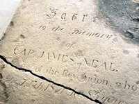
Bob Enoch Monday said he was mowing Saturday at the Tavenner Cemetery in south Parkersburg where he decided to unearth a stone and found it was the marker covering the original grave of Capt. James Neal, the leader of the first permanent settlers who came to Parkersburg. Enoch is president of the Wood County Historical Society.
Neal, a Revolutionary War soldier, led a party from Pennsylvania to Parkersburg in 1785 when he built a block house east of the East Street Bridge. The block house later became known as Neal's Station.
In terms of Parkersburg's history, Enoch's find is big, said Ray Swick, historian for the Blennerhassett Island Historical State Park.
"It's major, major," said Swick with emphasis.
He compared the find to when a portrait of Harman Blennerhassett was found in Hawaii about 30 years ago.
"They don't come anymore important," Swick said.
Neal, born circa 1738, died in 1821, according to the stone, which corrects modern accounts of when he passed away. Neal died during the "sickly season" probably from yellow fever, Enoch said.
His remains and his family's were moved from Tavenner to the Mount Olivet Cemetery in 1915, Enoch said. The Tavenner Cemetery was on land belonging to his son in law, Hugh Phelps, Enoch said.
Enoch has mowed over the stone numerous times. He knew a stone was there, but didn't know its size or to whom it belonged.
"I was actually thinking that I found Hugh Phelps' stone," Enoch said.
Phelps, Neal's son in law, played a larger role than Neal in the formation of Parkersburg, Enoch said.
Rather than upright, the 3-by-6 foot sandstone stone covers the grave, Enoch said.
The stone is called a ledger, said Christy Little, a cataloger and assistant curator at the Blennerhassett Museum. "Sacred" at the start of the inscription is too far below the top of the stone for it to have been upright, she said.
It's unknown why the stone would not have been taken to Mount Olivet, Enoch said. It may have been too heavy to move, he said.
A possibility is the stone was left at the original site and used to fill in the hole, said Sam Church of Vaughan's Funeral Home. It was common in that time period, particularly in rural areas, that a stone would cover the grave, he said.
"We call it a grave blanket," Church said.
The stone was protected from the effects of time and weather by being covered by soil, Enoch said. Most of the inscription is easily read, although a portion of the bottom is cracked, he said.
"I'd say it's in very good condition," Enoch said.
Nothing has been determined on what to do with the stone, Enoch said. Any display would have to be under cover to preserve it and protect it from the elements, Swick said.
"This is a precious relic," Swick said.
http://cu.newsandsentinel.com/photos/index.php?id=2009412
Above link to pictures in newspaper gallery.