S
stefen
Guest
 NATURAL DISASTERS
Natural disasters occur by specific categories and sub-categories as shown below:
- Geological
- Earthquakes
- Volcanic
- Avalanches (snow, ice, mud or rock)
- Hydrological
- Floods
- Tsunamis
- Meteorological
- Cyclonic
- Blizzards
- Droughts
- Hail Storms
- Heat Waves
- Fires
- Tornados
- Lightning
- Health
- Famines
- Epidemics
However, based on continental United States disasters, California has the least loss of life and property damage of any state.
Of all of the natural disasters within California, people only relate to the shake, rattle and roll of earthquakes.
In fact, people living outside of this western state constantly make unsubstantiated commentaries without having the least bit of factual knowledge to support their premise or statements.
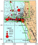
One only needs to remember that California is part of the ‘Ring-Of-Fire’ that encircles the Pacific Ocean. Due to the movement of the continental plates (3), whereby earthquakes result from stress-relieving slippages. This is a constant natural phenomenon and results in a variety of quakes along the NW-SE San Andreas Fault and along a multitude of secondary faults.
The continental plates mentioned is the Mendocino triple- junction fault (Cascadian subduction zone) located westerly of Cape Mendocino (Ferndale / Eureka, Humboldt County, California, commonly known as the confluence of the Pacific Plate, North American Plate and Gorda Plate.
A bit of trivia, Cape Mendocino is the most westerly landform of the north American continent.
If you will click on Google Earth and search for Cape Mendocino (or Ferndale Ca) you will see the line of the continental plates in the ocean west of the land mass.
Also visit the Historic Victorian Dairyland Village of Ferndale The Victorian Village of Ferndale in California's Romantic Redwood Empire
Amazon Forum Fav 👍


Attachments
Last edited: