Old Santa Fe Trail Cimarron Cutoff Fort Union to the State Line

Highmountain

Hero Member
Mar 31, 2004
616
33
New Mexico
The wagons would travel four abreast because it took far less time to form breastworks of wagons by traveling this way than in a single line. And time was of the essence in defending against Indian attack. It is said, from incomplete records, that in 1847 alone trader’s losses totaled 330 wagons, 6500 animals and 47 dead traders and teamsters. In 1868 from Fort Larned, George Custer was responsible for vastly reducing the number of Indian attacks on the trail. In 1870 the railroad that ended the Trail came through.
http://santafetrailhunts.com/santa-fe-trail-history.aspx

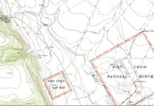
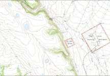
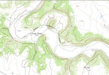
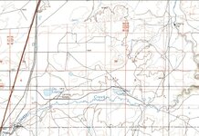
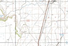
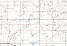
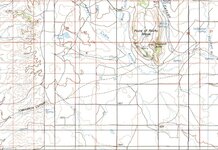
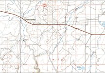
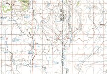
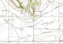
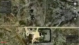
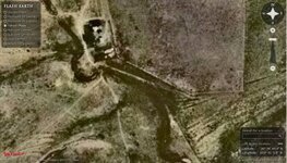
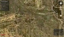
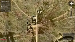
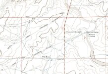
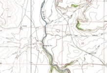
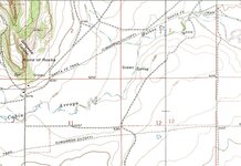
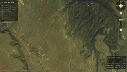
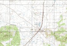
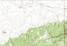
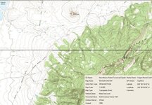
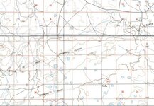
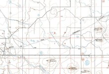
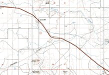
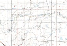
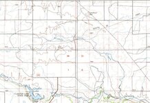
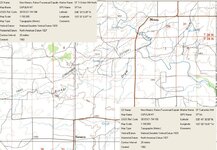
As you can see from the topos below the route is well established and easy to identify with precision on the topos. The most popular night stops are also fairly well estabished through the diaries and historical records of folk who traveled it, along with some of the many Indian attack sites.

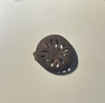
If anyone interested in trying to locate metal detecting sites along the route cares to post it might make some interesting discussion.
 

Attachments

  • Fort Union  35 55 11 1N 104 59 2W.jpg
    Fort Union 35 55 11 1N 104 59 2W.jpg
    45 KB · Views: 1,014
  • 2 Wagon Mound Cutoff topo WM 2.jpg
    2 Wagon Mound Cutoff topo WM 2.jpg
    235.8 KB · Views: 1,141
  • 1 Wagon Mound Cutoff topo NE 2.jpg
    1 Wagon Mound Cutoff topo NE 2.jpg
    80.4 KB · Views: 1,001
  • 1 Wagon Mound Cutoff topo.jpg
    1 Wagon Mound Cutoff topo.jpg
    84.3 KB · Views: 1,015
  • 6 Santa Fe Tr  from East Near Sophia Camps.jpg
    6 Santa Fe Tr from East Near Sophia Camps.jpg
    67.8 KB · Views: 845
  • 5 Santa Fe Tr  from East Near Chaves Mt Camps.jpg
    5 Santa Fe Tr from East Near Chaves Mt Camps.jpg
    143 KB · Views: 955
  • 4 Santa Fe Tr  from East Near Grenville Camp.jpg
    4 Santa Fe Tr from East Near Grenville Camp.jpg
    149.9 KB · Views: 859
  • 3 Santa Fe Tr  from East Seneca Spring Camp.jpg
    3 Santa Fe Tr from East Seneca Spring Camp.jpg
    64.3 KB · Views: 878
  • 2 Santa Fe Tr  from East Alamos Spring Camp.jpg
    2 Santa Fe Tr from East Alamos Spring Camp.jpg
    66.9 KB · Views: 857
  • Santa Fe Tr enters NM from East.jpg
    Santa Fe Tr enters NM from East.jpg
    168.2 KB · Views: 961
OP
OP
Highmountain

Highmountain

Hero Member
Mar 31, 2004
616
33
New Mexico
Incidently: The caves in the hills near Fort Union might also be a great place to detect. The military correspondence and reports from the US Archives tell of endless problems with soldiers visiting ladies who inhabited those caves and trading their gear for personal favors. On several occasions they raided the caves, recovered tons of Army equipment of every description, and ran the women off, but they always returned, always became a headache for the commanders of Fort Union.

Edit: Turns out this is better known than I'd have imagined:

New Mexico
The Land of Enchantment
Tourism Department

http://www.newmexico.org/western/explore/loma_parda.php
http://snipurl.com/2af6d [www_newmexico_org]


Loma Parda
In 1850, Lieutenant Colonel E. V. Sumner took his first look at the U.S. troops stationed in Santa Fe and the temptations offered to soldiers there.

He immediately determined to remove them from "that sink of vice and extravagance" by establishing forts only in remote areas. The plains near La Junta seemed a likely spot since the Santa Fe Trail came across there from Independence, Missouri. And, thankfully, no large towns could deter the soldiers from their duties. Loma Parda (Grey Hill), a small fanning community six miles away, was the closest town.

Soldiers didn't need a town, however, to bring them some of the delights that had been available in Santa Fe. Hardly had Fort Union been completed in 1851 when a group of prostitutes established their trade in nearby caves.

A Captain Sykes ended the sinful practice by capturing the women and shaving their heads; the caves now are a part of Cafion de Las Pelones, Baldwomen's Canyon.

But enterprising merchants in Loma Parda realized that what caves could provide, houses could provide better--or at least in more comfort. The town became what is called a "blow off' town, where the soldiers would go to gamble, dance, drink, and carouse with women. An officer named Hollister dubbed the place "a sodom," allowing Ralph Looney, in Haunted Highways, to make a memorable biblical pun by calling Loma Parda "Sodom on the Mora."

The Mora River did indeed run freely near Loma Parda, but it was Loma Lightning, a vicious whisky, that ran freely through the town. Hollister complained that the fort's guardhouse and hospital were filled with men who met up with the Lightning. Julian Baca's dance hall featured live music twenty four hours a day, and the thriving bordellos gave an ironic meaning to the name of the fort.

Commanding officers tried various ploys to keep soldiers away, usually by making the town strictly off limits. The most ingenious idea considered was to lease the whole town and then destroy it. But by 1872 Loma Parda had become a town of over four hundred, with its own post office. There was at least one establishment, the McMartin brothers' mercantile, that did legitimate business with the fort itself. Mainly, however, the offerings of the town were meant for the wayward soldiers. In addition to the brothels and bars were pool halls and dance halls that served a variety of libations, even champagne. Wagon service to the fort was available for one dollar per round trip, but that was far too expensive for the average soldier.

When the importance of Fort Union began to fade, so did Loma Parda. The post once lasted until 1900, or nine years after the fort was abandoned. A few families kept farming in the area, but by World War II it had been abandoned entirely. The only bridge into town washed away in 1948 and has never been replaced. A footbridge now provides access to the town.

Shadowy figures have been seen roaming about the town ruins at dusk by tourists and locals. The stories here vary. Many say that the old townsite is haunted by the spirits of prostitutes who come down from Cafion de Las Pelones. Other reports claim that the ghosts are lost souls who lost their lives in the town sometime during its violent past.


History of the Santa Fe Trail in New Mexico
http://www.santafetrailnm.org/sfthistory.html

Sodom on the Mora
This was the nickname given to what started out as a respectable and even peaceful little village on the Mora River a few miles upstream from Watrous. It began as a town of hard-working Hispanos who raised sheep and crops and fought all the hardships of life in the New World. For generations they survived drought, floods, and attacks by Indians and endured the extremes of heat in the summer and deep snow in the winter. They were hard-working and decent people. Unfortunately, that is not what they will be remembered for. Now essentially a ghost town, Loma Parda was forever changed when Fort Union moved into the neighborhood.

You could also have watched as dragoons, teamsters and cowboys headed up this valley to Loma Parda for a wild night of gambling and drunken debauchery or seen the convoys of wagons hauling logs from the mountains to be cut up and shipped in Watrous. You could have heard the intolerable screech of the two-wheeled Spanish style carts loaded with wool and hides and seen the pack trains of mules carrying buffalo hides as they all headed for markets in Missouri. This Valley has seen an incredible amount of history.
 

Attachments

  • Loma Parda Ghost town2.jpg
    Loma Parda Ghost town2.jpg
    7.7 KB · Views: 1,672
  • Loma Parda Ghost town1.jpg
    Loma Parda Ghost town1.jpg
    14.8 KB · Views: 795
  • Fort Union topo2.jpg
    Fort Union topo2.jpg
    68.7 KB · Views: 851
  • Fort Union topo1.jpg
    Fort Union topo1.jpg
    65.1 KB · Views: 886
  • Loma Parda Ghost town topo.jpg
    Loma Parda Ghost town topo.jpg
    72.2 KB · Views: 903
  • 11 Santa Fe Tr  from East Ocate Creek Camps.jpg
    11 Santa Fe Tr from East Ocate Creek Camps.jpg
    174.4 KB · Views: 832
  • 12 Santa Fe Tr  from East Colmer Camps.jpg
    12 Santa Fe Tr from East Colmer Camps.jpg
    150.9 KB · Views: 773
  • 9 Santa Fe Tr  from East Chico Creek Camps.jpg
    9 Santa Fe Tr from East Chico Creek Camps.jpg
    177.1 KB · Views: 887
  • 8 Santa Fe Tr  from East Point of Rocks Camps.jpg
    8 Santa Fe Tr from East Point of Rocks Camps.jpg
    189.7 KB · Views: 850
  • 10 Santa Fe Tr  from East Taylor Springs Camps.jpg
    10 Santa Fe Tr from East Taylor Springs Camps.jpg
    176.3 KB · Views: 806
  • 7 Santa Fe Tr  from East Palo Blanco Cr Camps.jpg
    7 Santa Fe Tr from East Palo Blanco Cr Camps.jpg
    213.7 KB · Views: 837
OP
OP
Highmountain

Highmountain

Hero Member
Mar 31, 2004
616
33
New Mexico
Point of Rocks was a bad'un for attacks as the graves bear testimony.

I'd guess the one near the Canadian Crossing gives an indication they were on the run when it happened.

I didn't include the gravesites more than 1/4 mile from the marked trail on the topos, but a person who's interested could easily locate those, and I'm guessing they're also attack sites.

I also haven't included an intriguing place on Seneca Springs, appears to be an abandoned dwelling with a corral astride the trail. I'm wondering if it isn't the remains of someone's attempt to establish an inn or lodging toward the end of the lifespan of the trail, but after the Comanche were doing other things with themselves besides attacking wagon trains after Ranald McKenzie victimized them by making them cut it out.

--------------------------

The Flashearth.com image of the dwelling or commercial operation to the south doesn't show it to have any equipment, vehicles, and the buildings appear to be in disrepair. Looks as though nobody's living there.
 

Attachments

  • 13 Santa Fe Tr  Point of Rocks Camp detail.jpg
    13 Santa Fe Tr Point of Rocks Camp detail.jpg
    150.4 KB · Views: 982
  • 19 Santa Fe Tr Old Moses has a lot of abandoned houses and SF Tr campsites.jpg
    19 Santa Fe Tr Old Moses has a lot of abandoned houses and SF Tr campsites.jpg
    66.6 KB · Views: 789
  • 18 Santa Fe Tr seneca Spr Xing apparently abandoned ICBM silo.jpg
    18 Santa Fe Tr seneca Spr Xing apparently abandoned ICBM silo.jpg
    53 KB · Views: 771
  • 17 Santa Fe Tr definite campsite at Barela Spr Xing.jpg
    17 Santa Fe Tr definite campsite at Barela Spr Xing.jpg
    74.4 KB · Views: 773
  • 16 Santa Fe Tr point of rocks dwelling to the south.jpg
    16 Santa Fe Tr point of rocks dwelling to the south.jpg
    64.3 KB · Views: 783
  • 15 Santa Fe Tr Old Moses possible ghost town.jpg
    15 Santa Fe Tr Old Moses possible ghost town.jpg
    143.9 KB · Views: 869
  • 14 Santa Fe Tr gravesite quarter mile fr tr Canadian Xing.jpg
    14 Santa Fe Tr gravesite quarter mile fr tr Canadian Xing.jpg
    153.4 KB · Views: 818
  • 13a  Santa Fe Tr  Point of Rocks attack sites.jpg
    13a Santa Fe Tr Point of Rocks attack sites.jpg
    136.4 KB · Views: 872
C

coloradocav

Guest
I've done many many hours of research over the years on this area, I've been to a couple areas near Ft. Union, just finding the time to go is hard. I've mostly researched military camps but there are a few massacre sites too.
 

Rob in KS

Hero Member
Aug 21, 2006
648
213
Middle of Kansas
Primary Interest:
All Treasure Hunting
Thanks for the post. This is interesting stuff. I have permission on a wheat field near the trail in Kansas. I can't wait for the wheat to be harvested next summer. I've been doing a lot of reading while I'm waiting.

I did some hunting next to the fence line and found part of an old horse bit ( I think). It's much older than the relics I usually find around here. I did a little detecting in the field ( owner said I could ) and hit a dozen targets in a 200x100 foot area. I couldn't dig anything, but I'm excited at the possibilities. I know I'll find a ton of stuff, hopefully some of it will from the trail.
 

Attachments

  • 000_1067.jpg
    000_1067.jpg
    27.6 KB · Views: 838

Top Member Reactions

Users who are viewing this thread

Top