Educate me on where to look.

archer66

Sr. Member
May 3, 2009
454
151
Northeast Missouri
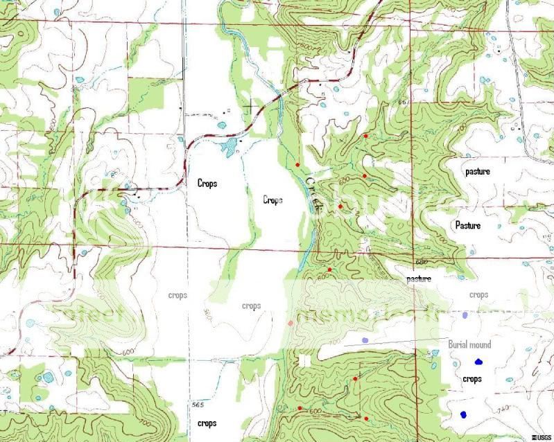
I am a newbie when it comes to artifact hunting. I have found a good number of points etc over the last year, every one of them in creeks. The main reason is that creeks are all that I have to hunt. Hopefully I will be getting permission to hunt the neighboring properties which are crop fields. Please look at the pic below and give me pointers if you don't mind. The big block of timber in the pic is my place. I have found points in every creek that I have marked with a red dot. The blue dots in the fields to the east are fields where my dad found points when he was a kid back in the 1950's. There are two burial mounds on the farm...one of which I have marked in the photo. From your experiences, considering topography, where would the most likely camp sites have been located? Where would you begin your search. Keep in mind that the open fields on our place are in hay or pasture so I won't have much success there, but do you see any likely spots in the crop fields? I have some ideas but was hoping you "experts" could give me your thoughts to help me narrow down my search.
topo.jpg
 

Upvote 0

Tnmountains

Super Moderator
Staff member
Jan 27, 2009
18,716
11,709
South East Tennessee on Ga, Ala line
🥇 Banner finds
1
Detector(s) used
Tesoro Conquistador freq shift
Fisher F75
Garrett AT-Pro
Garet carrot
Neodymium magnets
5' Probe
Primary Interest:
All Treasure Hunting
Fun project. I cant write on your map trying to figure it out on this mac.
 

OP
OP
archer66

archer66

Sr. Member
May 3, 2009
454
151
Northeast Missouri
TnMountains said:
Fun project. I cant write on your map trying to figure it out on this mac.

I don't know anything about Mac computers, but if you have paint you can open the photo in paint and edit.....
 

Th3rty7

Silver Member
Jan 24, 2009
3,314
247
»»--------->
I'm trying to get a sense of scale here, are those small round bodies of water ponds, or springs? Any idea what the area of land contained in one of the large squares?

Lots of possibilities imo. I noticed you have found stuff in the higher elevations in creeks. There could be some camp sites along the ridge that parallels that largest creek. For me the second and third terrace flats above rivers and creeks have always produced. Use your imagination to picture where that creek was thousands of years ago, it was probably a much larger river then. Evidence of the old plain can usually be seen in surrounding hills and higher spots that were formed by the water. Above these areas on flat, higher spots is where I'd concentrate my time.

If those are springs I'd walk all around them especially when they're down. The fields to the west of the large creek look like they could be lower and part of an ancient flood plain, that could be a waste of time to walk. I'd check around all bodies of water near your pasture land.

The high areas above or that overlook the intersection of smaller streams into creeks are always worth your time imo.

It looks like you're off to a really good start with what you've already established and what your father found in the past.

This is just my opinion from my own experiences in hunting new areas, some times you can do all the research in the world, but just walking eroded areas, even where you least expect can sometimes pay off. Trial and error, when you start seeing flakes and worrked pieces, slow down, take your time and really concentrate on those areas.

good luck, the topo looks like exciting areas to explore.

p.s. sorry if this is sort of jumbled mess, it's early and the brain isn't functioning at normal speed yet.
 

SoIll

Hero Member
Oct 6, 2008
690
32
Il
Those fingers of land that stretch out over that creek are probably loaded.
I bet the biggest part of it though is where the road is.
The incline doesn't look steep.
What makes you think it's a burial mound anyway?
The reason I ask is because I've heard a lot of people call all kinds of humps mounds/burials that weren't.
If it's not a burial mound and just a big hump then that's your site.
JMO
 

OP
OP
archer66

archer66

Sr. Member
May 3, 2009
454
151
Northeast Missouri
thirty7 said:
I'm trying to get a sense of scale here, are those small round bodies of water ponds, or springs? Any idea what the area of land contained in one of the large squares?

Lots of possibilities imo. I noticed you have found stuff in the higher elevations in creeks. There could be some camp sites along the ridge that parallels that largest creek. For me the second and third terrace flats above rivers and creeks have always produced. Use your imagination to picture where that creek was thousands of years ago, it was probably a much larger river then. Evidence of the old plain can usually be seen in surrounding hills and higher spots that were formed by the water. Above these areas on flat, higher spots is where I'd concentrate my time.

If those are springs I'd walk all around them especially when they're down. The fields to the west of the large creek look like they could be lower and part of an ancient flood plain, that could be a waste of time to walk. I'd check around all bodies of water near your pasture land.

The high areas above or that overlook the intersection of smaller streams into creeks are always worth your time imo.

It looks like you're off to a really good start with what you've already established and what your father found in the past.

This is just my opinion from my own experiences in hunting new areas, some times you can do all the research in the world, but just walking eroded areas, even where you least expect can sometimes pay off. Trial and error, when you start seeing flakes and worrked pieces, slow down, take your time and really concentrate on those areas.

good luck, the topo looks like exciting areas to explore.

p.s. sorry if this is sort of jumbled mess, it's early and the brain isn't functioning at normal speed yet.

Thirty7, sorry I should have put a scale on the pic to help with that. The picture posted covers an area 2 miles from end to end (north/south) by 2.6 miles side to side (east/west). The blue circles on the map are ponds (some may be spring fed, others are runoff fed). The small creeks that feed into the larger creek are primarily field runoff but there are some springs as well). The topography in the area is very much Karst in nature with numerous sinkholes and caves. The big creek in the picture feeds to an even larger creek, which in turn feeds into a river, which in turn, miles away, drains into the Mississippi River. I was actually thinking those fields to the east of the timber and to the west across the flood plain...the open areas around 700 to 710 foot elevation would be easiest for searching for campsites and I know I'll find points in them if they are uncovered. The problem I see when I look at the topo is that if I were a primitive man I would want my camp as close as possible to the largest source of water (the bigger creek). The problem with that is the best sites are the ridge tops just west of the creek and they are all heavily timbered. What I don't know is how many thousands of years they've been covered in timber, but from what I've read in a book called "The Pre-History of Missouri", I feel like those locales have been timber for thousands of years. I have been assuming that ancient camps would have been in open areas or did they establish camps in the timber (assuming the timber was there)? Another point is that I don't know how much water would have been in that bigger creek valley over the years nor do I know how much was in the smaller feeding creeks. I am assuming that they would have wanted their camps near the water, but if there was plenty in the smaller creeks they may not have focused on the big creek?? But that big creek to me has to be where life centered? The springs add yet another dimension as I don't know what their flow was like back then. There are two on our place that flow pretty much year round.
 

OP
OP
archer66

archer66

Sr. Member
May 3, 2009
454
151
Northeast Missouri
SoIll said:
Those fingers of land that stretch out over that creek are probably loaded.
I bet the biggest part of it though is where the road is.
The incline doesn't look steep.
What makes you think it's a burial mound anyway?
The reason I ask is because I've heard a lot of people call all kinds of humps mounds/burials that weren't.
If it's not a burial mound and just a big hump then that's your site.
JMO

The second is a pic of a pair of mounds in the middle of the hayfield on my grandfathers farm. My family has been farming around these since the 1930's...they were dug by someone before my grandfather bought the place in the 1930's. Each mound is probably 30-40 feet in diameter and between 2 and 4 foot above the surrounding field. They are seperated by about 30-40 feet. Both are covered with flat rocks but are flattened out on top rather than rounded or domed....actually are a little concave on top, I'm guessing from settling over the years and from having been dug in. I don't know what was found when they were dug because the folks that did it are long dead and my grandfather never asked the previous owner of the farm. The first pic below is a set of mounds almost identical to the first on a different ridgetop about half a mile away. They were dug as well.

When you mention the fingers of land over the creek do you mean the timbered ridges to the east of the biggest creek?
 

Attachments

  • P1040845[1].jpg-thumb.jpg
    P1040845[1].jpg-thumb.jpg
    34.2 KB · Views: 218
  • P1040848[1].jpg-thumb.jpg
    P1040848[1].jpg-thumb.jpg
    31.5 KB · Views: 205

Tnmountains

Super Moderator
Staff member
Jan 27, 2009
18,716
11,709
South East Tennessee on Ga, Ala line
🥇 Banner finds
1
Detector(s) used
Tesoro Conquistador freq shift
Fisher F75
Garrett AT-Pro
Garet carrot
Neodymium magnets
5' Probe
Primary Interest:
All Treasure Hunting
This is driving me crazy. Macs dont have paint thats a windows program. I live by topo maps and thats how I mostly hunt..everything :icon_scratch:
 

SoIll

Hero Member
Oct 6, 2008
690
32
Il
Yes the tops of those ridges and if there's any erosion on the slopes I'd check that too.
Check everywhere :thumbsup:
 

Top Member Reactions

Users who are viewing this thread

Top