Michiana Hunting

paxdruidia

Greenie
Jul 21, 2015
16
7
Michiana
Primary Interest:
All Treasure Hunting
I am going to take a stab in the dark here, I tend to avoid forums and posting, but the quality of people here is very impressive.

I am in north central Indiana, very close the MI line. I have had some small luck in Goshen (my hometown) around the area west of Waterford mills, and to the south near the old location of aupenuebee.
what I am struggling with is the utter lack of any records or moderately easy researchable places for records on old indian settlements, trails, etc. I keep running across other people's similar frustrations and statements of how the settlers "purged/erased" any sign of previous occupants. Northern Indiana is a terrible place for history, there seems to be a strong tradition of ignoring anything that happened before 1825.

1) does anyone have a good website or book to search these things?
2) does anyone on here live in Michiana and know a good deal of pre-settlement history?
 

Upvote 0

justonemore

Sr. Member
Oct 31, 2011
375
298
Indiana
Primary Interest:
Relic Hunting
Welcome to the site Pax!
I'm over in LaPorte county so not too far down the road from you. Your right as to prehistory of the area, greatly lacking and very vague. You have to do a lot of deep, deep digging to get lucky and find bits of info from time to time. Farmers, Local libraries and historical museums at times will turn up a shred of information. Often collections displayed will have the finders name. Look those up in old plat maps and you find a site. Plat maps are great for finding likely sites and I don't know if your county does (Elkhart?) but LaPorte county and Berrien county to the north of me in Michigan uses a google type map that shows who owns the land and how big it is. Get permission and walk the creeks and streams gravel or sand bars, walk the sandier rises/knolls/hills near those creeks and streams. Internet searches for various names terms etc in your vicinity help too. I found two different mound sites by doing so. Can't walk the actual site on one but walk three fields surrounding it and have found plenty of artifacts.
Those Indians were all over this place!
 

Last edited:
OP
OP
P

paxdruidia

Greenie
Jul 21, 2015
16
7
Michiana
Primary Interest:
All Treasure Hunting
awesome! this is a great crowd.
I will be trolling this website and the satellite for the rest of my work day now...

justonemore, I do envy you being over by LaPorte, so much more over thataway. i'm pinned down here quite well with kids, work, and visitation weekends. gotta make do with small evening trips in the land of nothing.
 

releventchair

Gold Member
May 9, 2012
22,363
70,520
Primary Interest:
Other
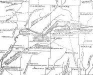
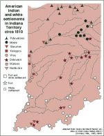
A trail map.
Native American Conquest


Another map showing waterways as travel routes due to locations of natives. Click to enlarge..

soup-line.jpg
 

Last edited:
OP
OP
P

paxdruidia

Greenie
Jul 21, 2015
16
7
Michiana
Primary Interest:
All Treasure Hunting
wow, now that is fascinating...
I always suspecting something was up with those, I've come across them up north in Huron land and seen several around here.
could you post the link the map above came from? its a little too south for where I can get to on my small scale outings.

you guys rock.
 

justonemore

Sr. Member
Oct 31, 2011
375
298
Indiana
Primary Interest:
Relic Hunting
Plenty of artifacts out your way too!
Are you on Facebook? if so check out this page: https://www.facebook.com/groups/846028232076249/
Marvin Hoover lives in your area and he's been finding them for years. I've been trying to get him this way and he's tried to get me to his area for a while, maybe this fall we all hook up and take a walk.
 

Last edited:

releventchair

Gold Member
May 9, 2012
22,363
70,520
Primary Interest:
Other
Great gramps tilled fields about a mile from a lake.
He had cigar boxes of finds picked after plowing and rain exposed them over the years.
A mile is far enough to be out of a camps impact on game it seems there.
Outside of gravel bars and eroded areas the river here(north) has a couple feet or more of silt from spring flooding, plus leaf fall each year.
One steel trap showed up about three feet below ground level in a cut bank. Last made in around 1920 but last used?
Tilled fields are tempting, but depends on a variety of localized factors.

soup-line.jpg
 

OP
OP
P

paxdruidia

Greenie
Jul 21, 2015
16
7
Michiana
Primary Interest:
All Treasure Hunting
that's a great map! I had a much smaller version that was a cell phone pic someone took of a sign at some park around here in the 70s.
i'm currently hunting the area between the top 3 on the right side, potawatomi camps. its a lot of ground, and I've been trying to cut it back by localizing to trails/settlements/stopping points between. I need to suck it up and get a kayak, everything so far has been on Elkhart River.
 

Mark Todd

Hero Member
Apr 22, 2014
705
684
Primary Interest:
All Treasure Hunting
Most counties have early histories written between 1850 &1920, often giving information township by township of information about many things including prehistoric settlements and artifacts in a given place, but you'll need to do some serious reading. These histories are usually are available for reading at the closest public library. Good Luck!
 

Top Member Reactions

Users who are viewing this thread

Top