Flooding My Memories - The 1982 Flood
The fall of 1982 and spring of 1983 ware exceptionally wet. Experiencing the flood which resulted from the continuos day after day of rain was one of my rarest relic hunting opportunities. The event still lives in my mind and because I love to find relics it keeps prodding me to try to visit there again after floods.
I was living in Eureka, Missouri which is a small town outside of St. Louis city limits about twenty miles. There had been smaller floods while I lived there, as friends have told me it floods almost every year, although every flood's intensity is different and causes different amounts of damages. Some years it floods in the spring, other years in during the fall. It could be a small flood, or like the flood of '93, so huge that it made national news, and devastated lives throughout much of the Mississippi River basin. The flood of '83 was not as cataclysmic as the flood of '93, yet even then the Meremec River, tributary to the Mississippi, flooded at their junction for many miles back along both river bottoms.
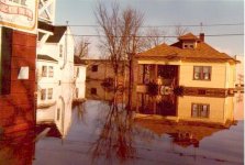
See the image of Eureka Missouri flooding in 1982 from the Skelly gas station looking North.
My hunting buddy Tom Commiskey and I would be out in the fields every weekend. Sometimes both days, but for sure at least one of the two. The long trek up and down the hills to fields, and once in the fields, tromping their seemingly endless lengths. Tom lived in Kimmswick and the most direct route for him to the field were winding back country roads. As the crow flies it might only be a few miles, but by the twisting county roads, many miles, and much more time. I would drive the fifteen miles from my house to the site to meet him We would drink some coffee and discuss strategy for a while, all the time we were looking out over the huge expanse of cultivated field. Seeing the foothills covered with trees, and no one else around always made me think of how this land must of looked just a short two hundred years ago.
The rivers and creeks we hunted in Jefferson and St. Louis counties. We liked hunting along The Big River and The Meremec River as there were plenty of families in the area we knew or a friend of ours knew, through which we could obtain permission to hunt. The rivers there were what we referred to as two tiered. The lowest terrace, where the river was located was usually forested, extended anywhere from ten to thirty yards from the river in the river bottom area. The second terrace was normally the cultivated field that could be fairly minimal in size to very, very large. The lush Ozark foothills, adjacent to the river bottom, form steep bluffs abutting the river on a side with the other far away across the second terrace.
The forest that covers the hills which followed the river bottoms were thick with wildlife and huge trees. The trees on the lowest rise along the river were just as huge. Sometimes even more so since the tops were often the same height as those at the start of the second rise, yet they had to grow fifteen to twenty feet just to reach the second rise.
The rains kept coming and the river kept rising. A telephone call from some friends scrambled my wife and I to help evacuate other friends who lived in nearby Times Beach. The news forecast was calling for a record flood and the townsfolk were notified they were in danger. (This being the flood which occurred during the dioxin episode which events led to the "closing" of the town.)
We traveled with others to the homes located close to Times Beach and started loading trucks, cars and trailers with everything from out of the houses. Since there were many friends who lived there, we all worked as a team, forming a line, going in one door and out another grabbing an item in the house while we walked through and dropping off the item at the vehicle being loaded. After we had finished loading the vehicles and drove away we could not enter the main road out of town due to the amount of traffic. All the while we labored to excavate, those in St. Louis, hearing of the imminent flood, had traveled to the area to see the water. As we sat in line waiting to exit we could actually see the water rising, coming up the grass of the river bank and spreading across the lawns.
The river kept coming. The town of Eureka was approximate one mile from the river, and the flood waters reached the center of town. After the rains stopped, the flood waters still rose as the rain from further upstream continued to flow towards the town.
I traveled out the country roads, up and down the hills and on top of the ridges, hoping to get to my happy hunting grounds. I was not shocked to find the road flooded by the river where it come down out of the hills. The water was deep over the road, and the entire vista out over the farm fields was now a lake. The distant hills, now looked like islands. The farm located close to the hill was invisible except for the top of the roof and chimney. I traveled to that spot in the road every day to watch the water, waiting for the water to go down, inch by inch.
After the river stopped rising and crested, it seemed that the water just sort of stopped moving, and got much muddier. The mud left by the river is often the worst result of the flood waters. The water and mud combine to destroy or render useless almost everything it touches, covering like a brown paint whose odor smells like an outhouse on a hot summer day.
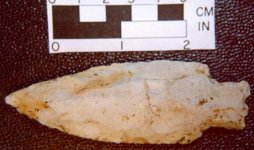
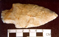
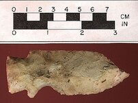
Finally after what seemed like weeks of waiting, I saw that the water was going to be low enough to travel across. Getting up early the next day which just so happened to be a Saturday, I headed out happily towards the field. When I pulled up at the field there was a car already there, an older man closing the trunk and walking towards the drivers door. As I parked and walked over to him and exchanged pleasantries, he said there were plenty still out there, and he had to get home as he was tired. He showed me two large bags of points, those I could make out looked like Etley's, and said they were all large points and he did not even bother picking up anything less than five inches long. We said good bye and I walked to the edge of the field, noting that the area was saturated. Still being just past dawn, I was surprised to find the man here so early, but not surprised that he may be tired. Not having traveled twenty feet into the field I was already sinking past my ankles in sloppy mud, and could not only feel but hear the sucking action of the mud as I lifted my feet.
I was amazed at the amount of flint in the field. Everywhere I looked the ground was carpeted with flint chips and relics. The ground was furrowed from the water action as it moved swiftly across the field. In the trough of the furrow the flint was thick, being as wide as six to ten inches, and an inch or two deep with flint. The upper areas around the troughs had been carpeted with flint as well, but was not deep like that found in the troughs. I thought about the foot or so of soil that had been washed away and all of the artifacts which had been exposed and left on the surface. I knew the soil removed was tremendous as the far corner of the field now had a mound of silt where the field previously was flat as it meet the river. I knew from previous hunts in the field that the farmers plow did not run in the direction of the flood furrows as they were now. The field I was in was approximately one hundred acres, so I knew I could only hunt a small portion.
I walked towards the North, towards the upper sandy area just at the base of the foothills. This area is lightly sandy and gently slopes away from the base forming a large plateau area. The flood furrows were less pronounced here than closer to the river, but still visible. I walked around the area picking up points with both hands, so busy I couldn't straightened up, just staying in a sort of crouch. The ground color in the entire river bottom changed as the subtle elevation changes took place, and up in this area the ground was sandy and lighter still. The ground was a light color of brown, but in places there seemed to be black areas - some were blacker than others. Trudging across the area without crossing your own foot prints was fairly easy due to making such large footprints in the mud. Even though the sun was out and the air was getting warm, the ground was like oatmeal, and did not want to let go of your feet.
Eventually, my legs started to grow very weary, and were aching, so I walked away from the plateau to the area closer to the river where the furrows were deepest. I was moving slower now but still gathering many relics. What would normally take me fifteen to twenty minutes to walk now took me almost an hour due to the muck and picking up relics.
I started picking up more relics as I walked to the east paralleling the river. Every now and then I would stop and strengthen up. My back was really starting to go, and so were my legs. The 'ol legs were already tingling from the exertion of the long walk. During one of these times I rested, I turned around and looked back up to where I was just an hour ago on the plateau. From a distance of two hundred yards or so the black spots suddenly became obvious. Those spots were the only remains of long ago Indian camp fires. From where I now stood I could see three columns of five rows, evenly spaced in a rectangular fashion on the plateau area. The "center" of each fire could be made out as the darkest area with what appeared as a smudge towards the east caused by the water action during the flood. I remembered the dark objects on the ground up there so I walked back up towards the plateau, and what I had earlier thought was garbage brought in from the flood, was really the charcoal remnants from the campfires.
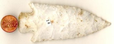
I filled up two canvas bank coin bags with whole points that day. Probably over two hundred points. I left on the ground those broken, only selecting complete specimens. For the better part of the day I was in the field slowly moving across the field gathering relics. My legs hurt for a week from the strain of pulling free of the muck. The next day in the morning when I went to work as a computer operator for Citicorp, I was attempting to tear off some reports from the printer, and found I could not bend my legs. I had to fall back upon the wall behind the printer and let myself sort of fall and slide down, my leg muscles being so weak and strained they could not support me in a half crouched position, I would just fall over. Whenever I attempted to use the staircase, I had no problem going up, but when I went down, I found that every step made my leg wobble and buckle. The problems with bending my legs grew worse over the next couple of days and then started to subside. For almost two weeks I had a leg paralysis and weakness.
I still think about the flood and the relics I found then. A great majority of my collection consists of those points found then during that event. The memory of the campfires, and knowing I will probably never again see something as rare makes me want to relive that period of my life. The flood waters, the mud, the relics recovered, those types of memories are forever.
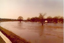
See the image of Eureka Missouri flooding in 1982 looking at Time Beach
Addendum
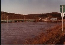
1 The Times Beach, Eureka flood commenced during the first week of December 1982. It is still the flood of record for the lower Meramec River since the start of gaging records in about 1920 at Times Beach. The peak discharge occurred on December 6, 1982 and was gauged as 145,000 cubic feet per second, estimated as a 50-100 year event. Only the August 1915 flood may have been greater than the 1982 event. Basically every structure in Times Beach was extensively damaged and many were destroyed. Even without the dioxin problem, Times Beach may not have recovered. Correspondence with Gary R. Dyhouse ,The US Army Corps of Engineers, St. Louis District.
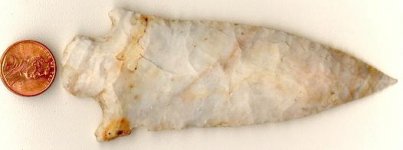
For comparison of the flood of 1983 to the flood of 1993, during the flood of 1993 the peak stage exceeded the previous record flood of record by 6.2 feet. The duration of flooding at high stages was unprecedented with the flood waters 10 feet or more over flood stage for 36 days, exceeded the "50-year flood" stage for 23 days and exceeded the "100-year flood" stage for 8 days. The total period of time the waters level was greater than flood stage during 1993 exceeded 130 days Before 1993, there were only 12 days total in the entire period of record, dating back to 1861, that exceeded flood stage by 10 feet or more. The Mississippi River at St. Louis exceeded flood stage late on June 26 and briefly dropped below flood stage (30 feet) on September 13, a total duration above flood stage of 80 days. At the maximum flow rate, enough sediment was passing St. Louis each day during the flood of '93 to build a farm of 4000-6000 acres (6.25-9.37 square miles) one foot deep. 2 While the flood of 1983 was not as great in magnitude of water damage or amount, the flooding of the area surrounding St. Louis in the floodplains was extensive. The "Davis Pipe," was found in the fields surrounding Eureka approximately at this time. See Central States Archaeological Journal April, 1987 for more information on the Davis Squirrel Pipe.
2 - MYTHS AND MISCONCEPTIONS OF THE 1993 FLOOD By Gary R. Dyhouse, The US Army Corps of Engineers, St. Louis District
The fall of 1982 and spring of 1983 ware exceptionally wet. Experiencing the flood which resulted from the continuos day after day of rain was one of my rarest relic hunting opportunities. The event still lives in my mind and because I love to find relics it keeps prodding me to try to visit there again after floods.
I was living in Eureka, Missouri which is a small town outside of St. Louis city limits about twenty miles. There had been smaller floods while I lived there, as friends have told me it floods almost every year, although every flood's intensity is different and causes different amounts of damages. Some years it floods in the spring, other years in during the fall. It could be a small flood, or like the flood of '93, so huge that it made national news, and devastated lives throughout much of the Mississippi River basin. The flood of '83 was not as cataclysmic as the flood of '93, yet even then the Meremec River, tributary to the Mississippi, flooded at their junction for many miles back along both river bottoms.
See the image of Eureka Missouri flooding in 1982 from the Skelly gas station looking North.
My hunting buddy Tom Commiskey and I would be out in the fields every weekend. Sometimes both days, but for sure at least one of the two. The long trek up and down the hills to fields, and once in the fields, tromping their seemingly endless lengths. Tom lived in Kimmswick and the most direct route for him to the field were winding back country roads. As the crow flies it might only be a few miles, but by the twisting county roads, many miles, and much more time. I would drive the fifteen miles from my house to the site to meet him We would drink some coffee and discuss strategy for a while, all the time we were looking out over the huge expanse of cultivated field. Seeing the foothills covered with trees, and no one else around always made me think of how this land must of looked just a short two hundred years ago.
The rivers and creeks we hunted in Jefferson and St. Louis counties. We liked hunting along The Big River and The Meremec River as there were plenty of families in the area we knew or a friend of ours knew, through which we could obtain permission to hunt. The rivers there were what we referred to as two tiered. The lowest terrace, where the river was located was usually forested, extended anywhere from ten to thirty yards from the river in the river bottom area. The second terrace was normally the cultivated field that could be fairly minimal in size to very, very large. The lush Ozark foothills, adjacent to the river bottom, form steep bluffs abutting the river on a side with the other far away across the second terrace.
The forest that covers the hills which followed the river bottoms were thick with wildlife and huge trees. The trees on the lowest rise along the river were just as huge. Sometimes even more so since the tops were often the same height as those at the start of the second rise, yet they had to grow fifteen to twenty feet just to reach the second rise.
The rains kept coming and the river kept rising. A telephone call from some friends scrambled my wife and I to help evacuate other friends who lived in nearby Times Beach. The news forecast was calling for a record flood and the townsfolk were notified they were in danger. (This being the flood which occurred during the dioxin episode which events led to the "closing" of the town.)
We traveled with others to the homes located close to Times Beach and started loading trucks, cars and trailers with everything from out of the houses. Since there were many friends who lived there, we all worked as a team, forming a line, going in one door and out another grabbing an item in the house while we walked through and dropping off the item at the vehicle being loaded. After we had finished loading the vehicles and drove away we could not enter the main road out of town due to the amount of traffic. All the while we labored to excavate, those in St. Louis, hearing of the imminent flood, had traveled to the area to see the water. As we sat in line waiting to exit we could actually see the water rising, coming up the grass of the river bank and spreading across the lawns.
The river kept coming. The town of Eureka was approximate one mile from the river, and the flood waters reached the center of town. After the rains stopped, the flood waters still rose as the rain from further upstream continued to flow towards the town.
I traveled out the country roads, up and down the hills and on top of the ridges, hoping to get to my happy hunting grounds. I was not shocked to find the road flooded by the river where it come down out of the hills. The water was deep over the road, and the entire vista out over the farm fields was now a lake. The distant hills, now looked like islands. The farm located close to the hill was invisible except for the top of the roof and chimney. I traveled to that spot in the road every day to watch the water, waiting for the water to go down, inch by inch.
After the river stopped rising and crested, it seemed that the water just sort of stopped moving, and got much muddier. The mud left by the river is often the worst result of the flood waters. The water and mud combine to destroy or render useless almost everything it touches, covering like a brown paint whose odor smells like an outhouse on a hot summer day.
Finally after what seemed like weeks of waiting, I saw that the water was going to be low enough to travel across. Getting up early the next day which just so happened to be a Saturday, I headed out happily towards the field. When I pulled up at the field there was a car already there, an older man closing the trunk and walking towards the drivers door. As I parked and walked over to him and exchanged pleasantries, he said there were plenty still out there, and he had to get home as he was tired. He showed me two large bags of points, those I could make out looked like Etley's, and said they were all large points and he did not even bother picking up anything less than five inches long. We said good bye and I walked to the edge of the field, noting that the area was saturated. Still being just past dawn, I was surprised to find the man here so early, but not surprised that he may be tired. Not having traveled twenty feet into the field I was already sinking past my ankles in sloppy mud, and could not only feel but hear the sucking action of the mud as I lifted my feet.
I was amazed at the amount of flint in the field. Everywhere I looked the ground was carpeted with flint chips and relics. The ground was furrowed from the water action as it moved swiftly across the field. In the trough of the furrow the flint was thick, being as wide as six to ten inches, and an inch or two deep with flint. The upper areas around the troughs had been carpeted with flint as well, but was not deep like that found in the troughs. I thought about the foot or so of soil that had been washed away and all of the artifacts which had been exposed and left on the surface. I knew the soil removed was tremendous as the far corner of the field now had a mound of silt where the field previously was flat as it meet the river. I knew from previous hunts in the field that the farmers plow did not run in the direction of the flood furrows as they were now. The field I was in was approximately one hundred acres, so I knew I could only hunt a small portion.
I walked towards the North, towards the upper sandy area just at the base of the foothills. This area is lightly sandy and gently slopes away from the base forming a large plateau area. The flood furrows were less pronounced here than closer to the river, but still visible. I walked around the area picking up points with both hands, so busy I couldn't straightened up, just staying in a sort of crouch. The ground color in the entire river bottom changed as the subtle elevation changes took place, and up in this area the ground was sandy and lighter still. The ground was a light color of brown, but in places there seemed to be black areas - some were blacker than others. Trudging across the area without crossing your own foot prints was fairly easy due to making such large footprints in the mud. Even though the sun was out and the air was getting warm, the ground was like oatmeal, and did not want to let go of your feet.
Eventually, my legs started to grow very weary, and were aching, so I walked away from the plateau to the area closer to the river where the furrows were deepest. I was moving slower now but still gathering many relics. What would normally take me fifteen to twenty minutes to walk now took me almost an hour due to the muck and picking up relics.
I started picking up more relics as I walked to the east paralleling the river. Every now and then I would stop and strengthen up. My back was really starting to go, and so were my legs. The 'ol legs were already tingling from the exertion of the long walk. During one of these times I rested, I turned around and looked back up to where I was just an hour ago on the plateau. From a distance of two hundred yards or so the black spots suddenly became obvious. Those spots were the only remains of long ago Indian camp fires. From where I now stood I could see three columns of five rows, evenly spaced in a rectangular fashion on the plateau area. The "center" of each fire could be made out as the darkest area with what appeared as a smudge towards the east caused by the water action during the flood. I remembered the dark objects on the ground up there so I walked back up towards the plateau, and what I had earlier thought was garbage brought in from the flood, was really the charcoal remnants from the campfires.
I filled up two canvas bank coin bags with whole points that day. Probably over two hundred points. I left on the ground those broken, only selecting complete specimens. For the better part of the day I was in the field slowly moving across the field gathering relics. My legs hurt for a week from the strain of pulling free of the muck. The next day in the morning when I went to work as a computer operator for Citicorp, I was attempting to tear off some reports from the printer, and found I could not bend my legs. I had to fall back upon the wall behind the printer and let myself sort of fall and slide down, my leg muscles being so weak and strained they could not support me in a half crouched position, I would just fall over. Whenever I attempted to use the staircase, I had no problem going up, but when I went down, I found that every step made my leg wobble and buckle. The problems with bending my legs grew worse over the next couple of days and then started to subside. For almost two weeks I had a leg paralysis and weakness.
I still think about the flood and the relics I found then. A great majority of my collection consists of those points found then during that event. The memory of the campfires, and knowing I will probably never again see something as rare makes me want to relive that period of my life. The flood waters, the mud, the relics recovered, those types of memories are forever.
See the image of Eureka Missouri flooding in 1982 looking at Time Beach
Addendum
1 The Times Beach, Eureka flood commenced during the first week of December 1982. It is still the flood of record for the lower Meramec River since the start of gaging records in about 1920 at Times Beach. The peak discharge occurred on December 6, 1982 and was gauged as 145,000 cubic feet per second, estimated as a 50-100 year event. Only the August 1915 flood may have been greater than the 1982 event. Basically every structure in Times Beach was extensively damaged and many were destroyed. Even without the dioxin problem, Times Beach may not have recovered. Correspondence with Gary R. Dyhouse ,The US Army Corps of Engineers, St. Louis District.
For comparison of the flood of 1983 to the flood of 1993, during the flood of 1993 the peak stage exceeded the previous record flood of record by 6.2 feet. The duration of flooding at high stages was unprecedented with the flood waters 10 feet or more over flood stage for 36 days, exceeded the "50-year flood" stage for 23 days and exceeded the "100-year flood" stage for 8 days. The total period of time the waters level was greater than flood stage during 1993 exceeded 130 days Before 1993, there were only 12 days total in the entire period of record, dating back to 1861, that exceeded flood stage by 10 feet or more. The Mississippi River at St. Louis exceeded flood stage late on June 26 and briefly dropped below flood stage (30 feet) on September 13, a total duration above flood stage of 80 days. At the maximum flow rate, enough sediment was passing St. Louis each day during the flood of '93 to build a farm of 4000-6000 acres (6.25-9.37 square miles) one foot deep. 2 While the flood of 1983 was not as great in magnitude of water damage or amount, the flooding of the area surrounding St. Louis in the floodplains was extensive. The "Davis Pipe," was found in the fields surrounding Eureka approximately at this time. See Central States Archaeological Journal April, 1987 for more information on the Davis Squirrel Pipe.
2 - MYTHS AND MISCONCEPTIONS OF THE 1993 FLOOD By Gary R. Dyhouse, The US Army Corps of Engineers, St. Louis District


Attachments
Upvote
0