The Templars left a map to the treasure!

OP
OP
T

treasure1822

Hero Member
Dec 9, 2010
521
238
Smithbrown, As I had headed my last entry with no offence, I see you took offence. Your the one who wanted proof, and i'm sorry to say that is the first place that pop up. Seeing that my quest has taken me 600 years into the past and not everyone can be a Michelangelo, I can look past the the creators short comings and afford him a little leeway in creative interpretation. I realize that there are two forms of criticism, Constructive and Destructive. Since you have made your first entry on this thread I have had to play "Justify my thoughts", I find this to be quite destructive. Now, I have see the other books that Harold T. Wilkins wrote but again your not listening to the words that I am saying. Did I not say that the map was a copy of a map that he had seen? And as for me finding the original map, I don't know about you but I work for a living and neither my time nor my funds can afford me the chance to get to the British Museum from the US. I am glad that you noticed my use of exclamation marks, but again your not getting it. It is not to argue a point, nor to enhance ones opinion. I believe that I use them like that in hopes that someone will pay a little more attention to what is said. Finally, you just stated that you believe "The Templar's and Sinclair are a modern myth", you joined in this thread with the sole goal of discrediting it. Do you have anything to back up your belief?
 

Smithbrown

Bronze Member
May 22, 2006
1,002
831
Treasure1822
You are the one who jumped into the thread and scattered messages in a very confusing way. I am sorry that I made the mistake of assuming you were a serious investigator who wanted their theory tested by others. I understand now that you are writing your own Dan-Brown style thriller. I hope you find your publisher and make your millions as you certainly won't be finding it on Oak Island.
 

OP
OP
T

treasure1822

Hero Member
Dec 9, 2010
521
238
Smithbrown,
Are you for real? Granted I have jumped between this thread and the one I started which has confused me. But as for the idea of my work being tested, I don’t think so. I was hoping for a validation on the information that I have acquired with the possibility of it supporting my theory. What you call testing was a personal observation of someone artistic rendition of a ship and a map. I am not the only person to believe that the “Boat Stone” is an important part of the Oak Island mystery, but I believe I am the only person who knows why. I am still hoping for a validation from a serious investigator though. I have found that being an investigator on this level requires a certain amount of imagination and open-mindedness for any progress to be made. A famous quote from the analogs of Sherlock Holmes goes “When you have eliminated the impossible, whatever remains, however improbable, must be the truths.” As for the millions that you speak of, I will leave that to the investors of Oak Island and the Canadian government. I myself will take away from this the satisfaction of the treasure being found 40 to 50 feet north of the cave-in pit as the map says.
 

OP
OP
T

treasure1822

Hero Member
Dec 9, 2010
521
238
Okay, the problem lies with me. I am not being clear enough. This map is from Harold T. Wilkins book, "Captain Kidd and his skeleton Island". It was drawn by Harold T. Wilkins in the early 1900's taken from a map that he said he had seen in the British museum. The rough Shape of the island, the text describing distance and direction, and the reference to North, South, East and West are what I believe to be a part of the original map. Everything else was probably added by Wilkins or the publisher to enhance the book. Gilbert Hedden had the island surveyed and it is known as the "Roper" survey. When they surveyed they found that the "Money Pit" was 14 rods North of the "Stone Triangle". They also found the 2 white granite stones with the 1/4 inch holes on the top of them and they were 25 rods apart. They found that if marked 7 rods west of the Eastern stone the "Stone triangle" was roughly 30 rods southwest of that point. The only thing that Hedden couldn't understand was the "7 by 8 by 4"-....Jean Lafitte had made a statement that A parrot will repeat what it hears, a monkey will imitate the movements of man, you can lure furred animals in to traps with shiny objects and man can be lead down bad or false paths. He also believed in one particular piece of the Bible, PROVERBS-14:15 and it reads something like "A simple man believes every word, the intelligent man gives thought to his steps". Think about it; remove everything except the shape of the Island, and the text (18 W by 7 E on rock, 30SW, 14N, Tree, 7 by 8 by 4 and the reference to North South East and West. Now orient the map so North is "UP" (and I know that it is not a "true" representation of true North to the position of the island) If you notice the words now will be "upside down". If I told you to read the directions again I believe everyone would say (18 W by 7 E on rock, 30SW, 14N, Tree, 7 by 8 by 4) because everyone has already read it. The problem with that is to be correct you have to start at the top and work your way down reading from left to right. So do me a favor, I want everyone to rotate each word 180 degrees just like taking a pin and putting it in the center of each word then rotate it so you can read it. What you have just done is change directions or go backwards. Now if you read it, it says to (7 by 8 by 4, Tree, 14N, 30SW, 18W by 7E on Rock) Now that doesn't make sense to the island but we are forgetting one important thing and that is the "Key" to this. "CHANGE DIRECTION" (7 BY 8 BY 4, TREE, 14 SOUTH 30 NORTHEAST, 18 EAST BY 7 WEST ON ROCK) There was a Stone found by Dan Blankenship and it had the letter "G" on it and it was found as close as I can figure was "Near the Cave-In Pit". That's where the map takes us and as I have said since before this forum, "The Templar's and the Masons are the same", the Masons are just a refined order of the templar's. So, where is the Letter "G"' found to a Mason, well besides in the center of the square and compass, On the Eastern Wall or "ABOVE THE ENTRANCES TO ANY MASONIC STRUCTURE". So, if any of you are wondering about the 7 by 8 by 4, stop and think out if you had to give someone directions. What are two things that have to definitely be given? How about a “START” and a “FINISH” point. The finish point is given on the map but the start is no so easy. Granted the map says 7 by 8 by 4, and Gilbert Hedden was thinking dimensional like triangle but is it possible to write it another way to sat it? Yes, the answer is 784. The 7 is by the 8 which is by the 4. Now this is the only ”Error” that I believe Wilkins made when he copied the map. I believe that Wilkins misread the number 7 and it should have been 1. The only reason I say that is because of the “Boat Stone” found in Westford Massachusetts found 30+ years ago. It has a “BOAT” and a “ARROW” which I would say it is pointing down and the number 184. And believe me that people who have actually view this up close said “184”. I am taking their word because hey, they were there not me. Break down the meaning of each thing on the stone. “BOAT”, which at looking at it is not a small dory or small fishing boat. It is a representation of a larger boat or sea going vessel. Where do you find these boats? On the sea, or in this case along the sea coast. “ARROW” which is what I would presume to be self-explanatory, it shows direction. But in this case since we do not know how the stone was oriented I cannot prove which way it pointed. The best that I can do is refer back to my maps directions and assume that the “ARROW” was pointing south and I am to reverse directions go backwards which means I head north. “184”, has to be distance, but they didn’t use miles or kilometers, they measured distance in what was known as a “LEAGUE” which is a unit of measure that is based on how far a person could walk in an hour and it ranges from 2.4 to 4.6 miles per hour. Now think about this, “SEA COAST” + “NORTH” + “184 LEAGUES” or 441.6 to 846.4 miles away. Does the location of Oak Island fall within those parameters? Oh yeah. But wait, with such a large difference between 441 to 846 mile, how do I know that it the right area? Remember how I have said that it was “Sinclair” and his men. That less than two miles from where they found the “Boat Stone” lies a carving of what they call the “Westford Knight”, supposedly Sir James Gunn a member of Sinclair’s party. They say that it has properties of “Viking” carving but the sword on the carving was 1400’s. Anyways, follow the shoreline on the southeastern side of Nova Scotia on the southern shores of Mahone Bay on what is now known as 2[SUP]nd[/SUP] peninsula. There is the “The Norumbega Vinland Stone” a memorial stone to immortalize the achievements of a person or people in their lifetime. The only problem, it’s not complete and it doesn’t make sense. If you are viewing the writing on the stone, you are also looking at Mahone Bay. Find the island that matches the maps. What do you do when you land on the island? You do exactly what McGinnis and his two friends did by accident, “FIND THE TREE” the starting point on the island. Please do not tell me that this was too complicated to figure out because more work to design the money pit and it’s nothing more than a false path. I have put a lot of time in this…..so where is the treasure. From the first marker in Westford Massachusetts follow the coast north walking for about 23 days. When you find the second marker look for the island that matches the map. Once on the island find the tree that sticks out. From there move 14 rods south to the stone triangle, then northeast so the 30 rod straight line goes from the stone triangle and thru the point that lies 7 rods west from the east stone and 18 rods east of the west stone. There you will find a stone with a “G” marking the entrance of the Vault. I theorize that this map was created not for just anyone, maybe it was meant for Sinclair’s family but they couldn’t put the pieces together and later the map and charts were donated to the British museum.
 

OP
OP
T

treasure1822

Hero Member
Dec 9, 2010
521
238
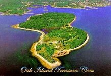
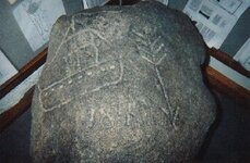
Here is the boat stone and ariel of Oak Island

oak island.jpg boat stone.jpg
 

Dave Rishar

Silver Member
Mar 6, 2008
3,212
3,256
WA
Detector(s) used
Tesoro Vaquero, XP Deus, Vallon Gizmo
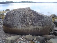
Do those stones look authentic to you? If so, why?

More importantly, do you seriously think that the same person or group of people was involved with both stones? And if they were not created by the same people (and it should be obvious that they were not), then what do they have to do with each other?
 

OP
OP
T

treasure1822

Hero Member
Dec 9, 2010
521
238
Okay! Where is this "Document" that has set the standard of how one should leave information to a treasure quest? If two people wrote my name I do not expect it to look the same. If I had 10 people draw me a cat, I will get 10 "Different" renditions of a cat. The only way I would expect anything to look the same is if one person did everything. My brother is an artist, I can't draw a convincing stick figure but yet we had the same parrents, raised the same way, went to the same school. Hell we are 10 months apart in age but by your standards we should be identical in performance and quality. It wasn't just Sinclair, he had 300 others with him. I am really surprised that you would expect it. Lay off the movies, it doesn't work that way.
 

Dave Rishar

Silver Member
Mar 6, 2008
3,212
3,256
WA
Detector(s) used
Tesoro Vaquero, XP Deus, Vallon Gizmo
It wasn't just Sinclair, he had 300 others with him. I am really surprised that you would expect it. Lay off the movies, it doesn't work that way.

Movies have nothing to do with it, and it certainly does work that way. Pick a culture, or a time period, or a tribe, or a government agency, or nearly whatever you'd like, and then analyze its artwork. You will see at least some consistancy. This is how such artwork is identified in the first place when there's not a signature at the bottom. One of these is very ornate and is of a certain style (Celtic? Hard to tell), while the other appears to have been chiselled by a child or a drunkard. (The ship on that stone also looks modern to me, but the quality of the work is so poor that it's hard to be certain.)

Those stones were not only carved by two different people, but two different people from entirely different "groups". The carvings themselves do not appear to be from the same time period either. I'm particularly troubled by the good carving, as the marks below the waterline don't appear to have weathered significantly differently than the marks above it. Of course, it's not a high resolution photograph so I may be missing something. Take a look at that though.

And Sinclair had 300 people with him? What is this based on besides complete speculation? I'm honestly curious.
 

Nov 8, 2004
14,582
11,942
Alamos,Sonora,Mexico
Primary Interest:
All Treasure Hunting
G'd morning treasure, coffee ??: Frankly that map is not of oak island. The orientation is no problem. the size is , it is far larger than oak island and has a mt range bisecting it with well defined canyons on the north side, which means it was intended for a northern approach. It has palms, presumable coconut, since it also shows a large coral reef with no channel which could only occur in tropical regions,. It's latitude also shows this and the long indicates the Atlantic.,

It is not Oak island. As for shape may I suggest looking at Guadalcanal. There are a no of islands small and larg with similar shapes.

Regaring theuse oof Sextants, they used Astrolabes, which on calm waters could be used with great accuracy, at sea programmatically. After all they successfully sailed the 7 seas with them


However in essence good thinking my friend. A refill ??

Don Jose de La Mancha

p.s. I posted this yesterday, but it somehow diaspperaed, I must have hit the wrong key.
 

OP
OP
T

treasure1822

Hero Member
Dec 9, 2010
521
238
Dave, Answer just a couple of questions and I want you to think hard, this go for Don Jose de La Mancha to. 1) Is there a posibility that Harold Willkins modified a version of a map that he had seen in the British museum? 2) Could people from different cultures have came together in the late 14th century? 3) Was it posible to keep a secret society after the 12th century? 4) Could have a group of people have searched for a land where there was no monarchy during that time? 5) Is it posible for a person to chissel a picture on a rock with no true "Artistic" tallent and have it resemble a boat? 6) How many men and how long would it take to complete what you already know about Oak Island. 7) Would the weathering of a stone be the same as above the water line as below? 8) is it posible for legends to contain some truth? 9) Is it posible for man to utilize artistic medians for purposes of other than Ornamental or personal expression? 10) What is "Artworks" basic use? 11) Does Oak Island have about the same shape as the Map? 12) Why does the discription on the Wilkins map match the man made and natural points of oak island, and remember that two of these points were not found until after the book was wrote.
 

Nov 8, 2004
14,582
11,942
Alamos,Sonora,Mexico
Primary Interest:
All Treasure Hunting
G'd afternoon Treasure, yer coffee is getting cold. You posted -->remember that two of these points were not found until after the book was wrote.

~~~~~~~~~~~~~~
What points?? I have no argument, except that that 'map' is not of Oak Island ??? Just trying to 'help' since I have all that I can handle down here.
Don Jose de La Mancha
 

OP
OP
T

treasure1822

Hero Member
Dec 9, 2010
521
238
Men of the Gentil class, I am not picking a fight. I am trying to show you that there could be a alternative answer. I am met with "No, can't be answers, When logic says "Maybe, could be". That means my answer become "Plausable". I am sorry Don Jose de La Mancha, but as you say it is not "oak Island", how do you know? The date, the mountains, the corral, the palm trees? That map could be based on something real but changed to help to sell a book on Captain Kidd. You guys are taking, "the Map", "The Stones", at face value. Again why are traights of Oak sland on that map? I hope you don't say coincidents.
 

Dave Rishar

Silver Member
Mar 6, 2008
3,212
3,256
WA
Detector(s) used
Tesoro Vaquero, XP Deus, Vallon Gizmo
Dave, Answer just a couple of questions and I want you to think hard, this go for Don Jose de La Mancha to. 1) Is there a posibility that Harold Willkins modified a version of a map that he had seen in the British museum? 2) Could people from different cultures have came together in the late 14th century? 3) Was it posible to keep a secret society after the 12th century? 4) Could have a group of people have searched for a land where there was no monarchy during that time? 5) Is it posible for a person to chissel a picture on a rock with no true "Artistic" tallent and have it resemble a boat? 6) How many men and how long would it take to complete what you already know about Oak Island. 7) Would the weathering of a stone be the same as above the water line as below? 8) is it posible for legends to contain some truth? 9) Is it posible for man to utilize artistic medians for purposes of other than Ornamental or personal expression? 10) What is "Artworks" basic use? 11) Does Oak Island have about the same shape as the Map? 12) Why does the discription on the Wilkins map match the man made and natural points of oak island, and remember that two of these points were not found until after the book was wrote.

1. Almost anything is possible, so yes. Of course, to consider this possibility would require accepting that the map is incorrect and would therefore be of questionable value.

2. This depends on which cultures we're discussing. As a general answer in the absence of further clarifying information, yes.

3. That's quite an open-ended question, so I'll take it at face value: theoretically, yes. To keep things in perspective, it would be theoretically possible for a person to build an internal combustion engine or an electric light bulb in the late 14th century, but this didn't happen until much later.

4. Yes. Depending on who the people were, they might have even known of such a place and how to get there.

5. Definitely, although one must wonder why someone with so little ability was entrusted with making a picture as important as you believe it to be - particularly when they had a guy that could do something like the other rock. Also, what's the number below the ship? It looks like "184".

6. Without more information, it's impossible to make such an estimate. Tell me how many men are available, what their skill breakdown is by trades, how many (if any) draft animals are available, and what tools and raw materials they brought with them, and I'll take a crack at it. Taking a guess without all of this information is simply that...taking a guess, and not even an educated one.

7. Unless the exposure began fairly recently, no.

8. Yes.

9. Ever seen a billboard advertisement? Of course.

10. Practically or philosophically? This is not a question that can be answered both accurately and briefly. If I had to try to accomplish both, I would say that the purpose of art is to convey ideas, stories, emotions, or any combination thereof.

11. Inasmuch as a corn flake does, yes.

12. Which parts match? The mountain range? The coral reef? The palm trees? The differences are much more numerous than any similarities. Honestly, the only similarity that I'm able to see is the general shape of the island, and it's only superficial. As I've already pointed out, even that is wrong.

I'm not sure what you're attempting to establish with these questions. Most of the specifics of your theories are technically possible, but more or less improbable. When a bunch of improbable ideas are combined to form a theory, this does not automatically legitimize all of them. Instead, it tends to amplify the error. I can accept a theory consisting of one garbage idea and nine good ones, but a theory based on eleven different improbable ideas tells me that the theory needs to be rewritten. This is all the more difficult in the case of Oak Island, as there are very few established and unquestionable facts to start with. Nearly every "fact" involved with the story can be shown to be inaccurate or even probably fabricated when one tracks them back to the beginning.

You mentioned that the map shares some similarities with Oak Island. So does the city of Bremerton, WA. We have a Smith's Cove for one thing. It doesn't mean that Bremerton is in any way connected to anyplace in Nova Scotia though. A few similarities do not make for a match, particularly when everything else is so far wrong. What are the other shared traits, and how do they stack up against the many dissimilarities that have already been mentioned?
 

OP
OP
T

treasure1822

Hero Member
Dec 9, 2010
521
238
The simularity as slight as you may think is enough to raise questions by others. draw the shape of a island by walking around it. How close do you think you will get to the actual shape? Probably as close as a Corn Flake. THe most important simularity is the text, 18w by 7e on rock, 30 sw, 14n, tree. These are actual linier dimensions to "man made" objects on Oak Island. Your taking the map at face value, why? As a skeptic which you have demonstrated, should be questioning everything. Is the idea of a author who had seen a map while doing research and copied the map because he found it intriging so far fetched? I believe the only thing that is factual on that map is the rough shap and the directional text. The rest is atmosphere created by the author to bring believability.
Gilbert had said that he had went to england and spoke with Wilkins. Wilkins had admitted to seeing the map and said it must have been in the British muesum. You say it's fake but have given no explanation of the text. I say it's partially real with an explination of the text.
 

OP
OP
T

treasure1822

Hero Member
Dec 9, 2010
521
238
5. Definitely, although one must wonder why someone with so little ability was entrusted with making a picture as important as you believe it to be - particularly when they had a guy that could do something like the other rock. Also, what's the number below the ship? It looks like "184".

Maybe it was "Sinclair Himself" that carved that one and the original map. Who knows.....
 

Top Member Reactions

Users who are viewing this thread

Top