The Templars left a map to the treasure!

OP
OP
T

treasure1822

Hero Member
Dec 9, 2010
521
238
Okay Reb, did you knotice the feathers that were carved on the stone? I believe that stone is telling you where tovgo. The featheres are placed in accordence to the points of the compass. The single feayher says to go east to the shore. Then go northeast to a place of great importance.as represented by the cross feathers. In native american belief it was a gift from the gods to get a eagle feather.
 

Rebel - KGC

Gold Member
Jun 15, 2007
21,680
14,739
Okay Reb, did you knotice the feathers that were carved on the stone? I believe that stone is telling you where tovgo. The featheres are placed in accordence to the points of the compass. The single feayher says to go east to the shore. Then go northeast to a place of great importance.as represented by the cross feathers. In native american belief it was a gift from the gods to get a eagle feather.


Gift from Great Spirit... YES! "Compass Readings"...? DOUBTFUL... dunno.
 

OP
OP
T

treasure1822

Hero Member
Dec 9, 2010
521
238
Oh, i'm sorry Reb....I misunderstood, I think i'm getting punchy.....I look for a reason for these carvings to be where they are and I don't buy the theory that some people saying there a hoax or some artist got board and decided to doodle and use bolders as their medium.
 

rowanns

Full Member
Jan 26, 2014
180
154
Nova Scotia
Detector(s) used
Garrett
Primary Interest:
Metal Detecting
I would bet that there are a few stone carvings like that between Westford Mass. And the Norumberga Vinland stone on the south end of Mahone Bay. Near the shore on a stone big enough to see.

Have you got coordinates for the location of that stone? Also, what do you mean by the "south end of Mahone Bay"? Are you talking about the bay or the boundary lines of the town treasure 1822? I'd like to check it out and I'm nearby geographically, so any information you are willing to provide would be greatly appreciated.


Cheers,
Rowan
 

OP
OP
T

treasure1822

Hero Member
Dec 9, 2010
521
238
Rowan,
[FONT=Lucida Grande, Lucida Sans Unicode, Arial, sans-serif] It’s on the Mahone Bay side of Second Peninsula. If you go along Prince’s Inlet Road to Young’s Lane, then walk along the beach at low tide, you will find it along there. There isn't any information on that particular stone, some believe that it is a modern copy of the Ramsund Carving. These stones were meant to be markers or monuments in recognition of "Someone's efforts" or "A groups efforts". [/FONT]
 

Rebel - KGC

Gold Member
Jun 15, 2007
21,680
14,739
Rowan,
It’s on the Mahone Bay side of Second Peninsula. If you go along Prince’s Inlet Road to Young’s Lane, then walk along the beach at low tide, you will find it along there. There isn't any information on that particular stone, some believe that it is a modern copy of the Ramsund Carving. These stones were meant to be markers or monuments in recognition of "Someone's efforts" or "A groups efforts".

Jedi Knights...?
 

miker28

Newbie
Dec 18, 2014
2
1
hollidaysburg, pa
Primary Interest:
All Treasure Hunting
as far as the mystery of oak island, i have no clue as to who buried whatever it is. but i have always believed that the ocean's level was lower and may have shown access beneath the island via cave or tunnel. depending on how large the access was, the architects could have place the mystery stash in a rowboat or raft and transported the stash to the point of burial and thus have opportunity to apply flood tunnels and/or boobytraps. the pit from above may have been dug for another access, but it may have been dug to retrieve the stash because i don't see anyone digging that hole twice. but then again, why the platforms of logs every 10 foot and inscribed stone at 90 foot? as to the inscriber of said stone, i feel it must have an english sort because of the measuring unit referred, i mean, the foot was probably not the common measurement term then. well that's how i see the oak island topic, i have looked for maps or graphs of ocean floor charts around oak island to check if a cave was possible but haven't been that lucky yet.
 

57chevy

Full Member
Oct 4, 2014
105
87
The West
Detector(s) used
Whites 6000 D Looking to find enough to replace it.
Replaced it with a Garrett 350
Primary Interest:
All Treasure Hunting
Some one please find the treasure, if there is one, so we can know the truth about Oak Island. There is a very expensive solution to Oak Island. Since it would involve the total destruction of the island, it will never happen.
 

FragFox

Jr. Member
Dec 21, 2014
60
37
Eastern Pa.
Detector(s) used
White's Coinmaster, Bullseye TRX
Primary Interest:
All Treasure Hunting
Some one please find the treasure, if there is one, so we can know the truth about Oak Island. There is a very expensive solution to Oak Island. Since it would involve the total destruction of the island, it will never happen.

Are you talking about this solution?
caterpillarbulldozerd11r-795078.jpg
 

swiftfan

Sr. Member
Feb 24, 2008
353
491
Pikeville, Ky
Detector(s) used
Garrett Ace 250
Primary Interest:
Other
That's an idea. The ocean level was lower. The "flood tunnel " is actually the access tunnel. Find the entrance, follow the tunnel to the vault. Also, the use of a cofferdam would have allowed them to dig off the eastern shore without being seen. If you have to get say 200feet down, and don't want a steep drop, then you have to go east "x" amount of feet, and start the tunnel. Good Idea.
 

n2mini

Hero Member
Jan 7, 2015
983
514
Triad NC
Primary Interest:
All Treasure Hunting
Some research would tell them roughly how much the tide level has risen over the years. However far back it was starting to have data keep on that type of stuff and then just apply to per year back some 300-400 years. Would be a good sized drop probably. I doubt that the town and or EPA would let them put a damn in now but they'd have to know approx. how far out to put it based on the tide level back then to make sure it is out past the water inlet area.

Assuming the Templars left whatever is there I'd think they would have kept some sort of record of it so that the next Generation could retrieve it..
 

beadman2

Jr. Member
Jan 3, 2015
69
20
Primary Interest:
All Treasure Hunting
i like treasure1822s theory.....maybe the g has a double meaning and also stands for gold....so why in the hell hasnt anyone dug under the g stone ?.....dig it up!
 

OP
OP
T

treasure1822

Hero Member
Dec 9, 2010
521
238
i like treasure1822s theory.....maybe the g has a double meaning and also stands for gold....so why in the hell hasnt anyone dug under the g stone ?.....dig it up!

Dan Blankenship discovered it while bulldozing the area. The only problem is that he discover the stone after he moved it so he doesn't know where it originally was. I do.....right where the "MAP" says the rock should be. And how do we know we have the right "Rock", the letter "G" which is placed over the alter.
 

OP
OP
T

treasure1822

Hero Member
Dec 9, 2010
521
238
Some research would tell them roughly how much the tide level has risen over the years. However far back it was starting to have data keep on that type of stuff and then just apply to per year back some 300-400 years. Would be a good sized drop probably. I doubt that the town and or EPA would let them put a damn in now but they'd have to know approx. how far out to put it based on the tide level back then to make sure it is out past the water inlet area.

Assuming the Templars left whatever is there I'd think they would have kept some sort of record of it so that the next Generation could retrieve it..

Ergo the "MAP".....but not just the map....the map is useless with out the "Boat Stone", the "Runic Stone". The "G" stone is the Final marker but it can be determined by the map.
 

Robot

Bronze Member
Mar 10, 2014
2,014
1,709
Primary Interest:
Other
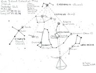
My "Star Map" can realign all "Present" and "Past" Markers on Oak Island!

Ergo the "MAP".....but not just the map....the map is useless with out the "Boat Stone", the "Runic Stone". The "G" stone is the Final marker but it can be determined by the map.

Celestial Map.jpg


"But" only on the Autumn Equinox

Next one - September 23rd, 2015
 

Top Member Reactions

Users who are viewing this thread

Latest Discussions

Top