Maybe it's Not in the Money Pit!

gjb

Full Member
Apr 21, 2016
240
307
UK
Detector(s) used
Garrett Ace 300i
Garrett EuroAce
Primary Interest:
All Treasure Hunting
Your work deriving this...Is to be...Admired!

Oh!...By the way...You can run from the Oak Island Forum...But you cannot...Hide!

Having had no response to this topic in the forumā€™s General Discussion (apart from Robotā€™s observation above) I thought I might try here possibly for one last time (due to a serious health condition).

While I appreciate that this subject has not been discussed on The Curse of Oak Island may I respectfully submit that the historical aspects of the series are not exactly a paragon of Oak Island research.

If there really is a treasure on Oak Island, why is there such an insistence that it has to be in the Money Pit? One potentially significant aspect of Oak Island is constantly overlooked - even dismissed as irrelevant. I refer to the several ground markers on the island specifically those at the east: the Drilled Rocks and the Stone Triangles. If these be original then they must have had a purpose more likely other than to draw attention to the Money Pit. By all accounts, this was far more obvious than any of the other ground markers (and I consider the Money Pit to be a ground marker, not somewhere you necessarily have to dig).

What if these features were not randomly positioned but were placed at strategic points on a ground plan - in effect, at key locations on a geometrical design - and that they were intended to be used to locate a point on the island other than the Money Pit?

Furthermore, what if, by taking the suggestion seriously, it were possible to recreate the original ground plan from knowledge of where these markers were reported to have been found? Maybe this might reveal a potential hot-spot for investigation.

I appreciate that these ground markers have been mostly wantonly destroyed and removed as being unimportant in the great scheme of things, but what if this continuing cavalier attitude to Oak Island is wrong? Also, what if the almost haughty preconceptions of writers on the mystery has influenced researchers to reject the very information thatā€™s required to make use of these markers?

What if instructions were left to enable someone to relocate the islandā€™s hot-spot? Unfortunately, such instructions would be likely to take the form of an item seemingly despised and disparaged by people claiming to have the intelligence and sense not to be so gullible. I refer, of course, to what would be termed a ā€˜treasure mapā€™.

This would not have to be a simple ā€˜pirateā€™ treasure map as in Treasure Island but a sophisticated mechanism in keeping with the apparent engineering skills of the originator of the enterprise. The purpose might simply be a contingency plan - a back-up in the event of anything happening to him.

I believe there is a possibility that sets of instructions dismissed by the majority of people as being the worthless fabrications of forgers and scammers may have been erroneously assessed and that when correctly interpreted and applied to the ground markers on Oak Island reveal a regular pattern of points on the ground.

Iā€™ve written a series of books on the subject, but Iā€™ve put together a web page presenting a geometrical plan of the east of the island and indicating how the instructions appear to work and where they lead. The question would then be: could this be coincidence?

I had hoped for some comments on the general forum about whether it is likely that anyone would create instructions for relocating a deposit - potentially by their heirs in the event of an untimely accident rendering them incapable of recovering it themselves, or simply as a bequest. Of course, the heirs could be a group of people with a goal that needed future financing (revolution etc.)

Maybe discussion here might get back to focus on Oak Island rather than on The Curse of Oak Island, though one of the maps has appeared more than once in the series. However, the reconstruction and the associated instructions as developed here use typically British / Colonial units of measure (the baseline shown is three sections of 15 rods and the flood tunnel would be 30 rods = 495 feet). There is far more to the geometry than this, but see the link below:

Oak Island Geometry and Treasure Maps

In closing, I apologise if deteriorating health does not permit me to maintain a discussion.
 

goldnsilver

Full Member
Jun 25, 2010
102
202
Maryland
Detector(s) used
Whites Beach Hunter ID
Vintage 1980's
Whites Goldmaster
Whites Coinmaster
Primary Interest:
All Treasure Hunting
Thanks for a well written post and the link for the "Oak Island Geometry and Treasure Maps". It is very logical that Oak Island was the receiver of one or more
treasure deposits over the years. It's also logical that some have been removed and other deposits may still remain. What is not logical to me is digging down
80' to 160' to hide a treasure that would need to be recovered (maybe quickly) at a later time.The rock markers would seem to play an important role in
the treasures original location. I don't believe in the constructed flood tunnels, it's just natural underground water flow. Again, thanks very much for your post!
 

OP
OP
G

gjb

Full Member
Apr 21, 2016
240
307
UK
Detector(s) used
Garrett Ace 300i
Garrett EuroAce
Primary Interest:
All Treasure Hunting
It is very logical that Oak Island was the receiver of one or more treasure deposits over the years. It's also logical that some have been removed and other deposits may still remain. What is not logical to me is digging down 80' to 160' to hide a treasure that would need to be recovered (maybe quickly) at a later time.

Thank you for your well-considered reply. The ground plan as developed tends to lead northeast of the Money Pit to the very slightly higher ground. It strikes me that this could have been sufficiently above sea level to support the frequent suggestion that the treasure was cached out of reach of the assumed flood tunnels.

Furthermore, if Gilbert Hedden's observation concerning the location of the Cave-In Pit is correct (and i see no reason to doubt him) then this excavation appears to have been found at one of the assumed seven map points (but for which no map appears to have been published). It might then be significant that the pit was dug to a depth just short of 20 feet.
 

Real of Tayopa

Bronze Member
Sep 4, 2016
1,942
9,101
Mexico
Primary Interest:
All Treasure Hunting
gentlemen and Ladies. The above post by GIB is precisely why I mentioned " the pit is a red herring. shortly after entering the pit you should find a tunnel in the wall, follow it to the actual vault, it is very shallow. but the it is not constructed with the idea of following it to recover the deposit. The tunnel leads underground to another spot on the Island, an undisturbed surface. This is one of the spots commented by/ on GIB. Follow the signs to access the deposit from the surface, which has never been disturbed. This obviously is/was the purpose of the original plans to protect the actual deposit. GIB, 5 *****


I exist to live, not live to exist
 

Last edited:

dmg2016

Jr. Member
Feb 8, 2019
28
32
Primary Interest:
All Treasure Hunting
Furthermore, if Gilbert Hedden's observation concerning the location of the Cave-In Pit is correct (and i see no reason to doubt him) then this excavation appears to have been found at one of the assumed seven map points (but for which no map appears to have been published). It might then be significant that the pit was dug to a depth just short of 20 feet.

I know that you have comment on this before, but I still find the maps and other documents described in the 1906 Collier Magazine article to be extremely fascinating. This map apparently showed seven deposits made around the island.
 

powrsurg

Sr. Member
Jul 5, 2016
319
364
Rocky Point, NY
Detector(s) used
Minelab Equinox 800
Whites Spectra V3I
Primary Interest:
All Treasure Hunting
I am almost 100% certain there is no treasure and has never been treasure on Oak Island. Im in the camp that anything found on the island has either been left there by previous searchers or just usual droppings from people who have been there through the ages.
 

gazzahk

Bronze Member
Nov 14, 2015
1,714
2,573
Primary Interest:
All Treasure Hunting
I am almost 100% certain there is no treasure and has never been treasure on Oak Island. Im in the camp that anything found on the island has either been left there by previous searchers or just usual droppings from people who have been there through the ages.
Yep! There is nothing to support ANY of the treasure theories about OI. NOT ONE SINGLE PIECE of evidence has ever been found to support a treasure buried on the island

(Other then the possibility that the original finders found a small amount of treasure at 10 or so feet). All these other speculations are based on zero evidence and zero logic...

Aladdin's lost cave is just as likely to exist...
 

freeman

Sr. Member
Apr 5, 2003
346
665
To put it bluntly as the logic exposes, the search started due to a story identifying one location and one location only. As that story and location is the origin, everything else, not involving the origin story location is pure imagination or speculation.
 

Last edited:

gazzahk

Bronze Member
Nov 14, 2015
1,714
2,573
Primary Interest:
All Treasure Hunting
Oh ye of little faith GIB and his maps are logic personified.

237-512.png

Now that did give me a laugh... Our understanding of logic as compared to fantasy is obviously very different

I think you should get this shirt

shirt-Black.jpg
 

freeman

Sr. Member
Apr 5, 2003
346
665
Sorry, I'm trying to figure out what your point is because everyone already knows that they (searchers since the beginning) were following a Spanish origin 'treasure map' on Oak Island and had done so from the start. All the contemporaneous reports just gave it (by the way the Robert Creelman mention here advised the Truro Syndicate).


3 with map.png
 

Last edited:

freeman

Sr. Member
Apr 5, 2003
346
665
And Doug Crowell published details of it a few times. It was even referred to on 'The Curse of Oak Island' for all those who use the show as their sole source of information.

DC1.png
 

Last edited:

freeman

Sr. Member
Apr 5, 2003
346
665
And copies of the map they used have been published also. Plus the dimensions ascribed to it are known as this was plotted it out on the ground with the marked and drilled stones as datum points to determine where to dig.

So exactly what is the mystery that is now being said to have been discovered about maps or drilled stones or patterns or dimensions that isn't already known and still being used?

threeall.png

As the fundamental factual origin details that started it all identified one spot and one spot only, and this is the totality of the information that spawned the whole thing, then to suggest the 'treasure' is elsewhere can only be pure unbased speculation.

Logical enough for you?
 

Last edited:
OP
OP
G

gjb

Full Member
Apr 21, 2016
240
307
UK
Detector(s) used
Garrett Ace 300i
Garrett EuroAce
Primary Interest:
All Treasure Hunting
To put it bluntly as the logic expises, the search started due to a story identifying one location and one location only. As that story and location is the origin, everything else, not involving the origin story location is pure imagination or speculation.

You're assuming a great deal. First, that the original tale that was put about is the correct interpretation of what was originally done and what was discovered - in fact, it was just a guess - that is, the early explorers decided that there was only one treasure on the island. Are you saying that because they said it, and because you believe it, this has to be the correct interpretation of the origins? Could there not be other interpretations? Are we now not permitted to present alternative hypotheses? You appear to be declaring that you know for sure that they, and you, couldn't possibly be wrong about this. Nice!

Second, you seem to assume I'm saying that there were necessarily multiple treasures. I don't happen to hold this view. It's possible that the pattern of points on the rhombus is to draw attention to its centre. That would mean one location.

In my view, the story of the origins could also easily be what you call, "pure imagination or speculation." Just because they believed it, and you seem to believe them, doesn't make it true.

I wish I could say that I'm relieved to hear there are people on the forum who know all the answers. Unfortunately, your theory, your hypothesis, your guess as to the answer, is as speculative as anybody else's. We just don't know what went on and why, but some of us are trying to find out. Raising hypotheses and testing them is part of that process. Testing at the Money Pit appears to be unproductive. Maybe it's time to look at what the rest of the island might tell us and find another hypothesis to check out.
 

OP
OP
G

gjb

Full Member
Apr 21, 2016
240
307
UK
Detector(s) used
Garrett Ace 300i
Garrett EuroAce
Primary Interest:
All Treasure Hunting
And copies of the map they used have been published also. Plus the dimensions ascribed to it are known as this was plotted it out on the ground with the marked and drilled stones as datum points to determine where to dig.

So exactly what is the mystery that is now being said to have been discovered about maps or drilled stones or patterns or dimensions that isn't already known and still being used?

As the fundamental factual origin details that started it all identified one spot and one spot only, and this is the totality of the information that spawned the whole thing, then to suggest the 'treasure' is elsewhere can only be pure unbased speculation.

Logical enough for you?

As I've pointed out before, the map you're using originally had nothing whatsoever to do with Oak Island. It was presented as a pirate treasure map of Guayacan published in El Tesoro de los Piratas de Guayacan by Ricardo Latcham. You might want to look opposite page 140 of the 1935 edition. The caption reads, "Mapa de los contorros de la bahia de Coquimbo y de Guayacan."

You claim that only the origins are important. The origins of this map lie in Chile - and by your logic that's where it belongs. Why introduce it into the Oak Island mystery?
 

n2mini

Hero Member
Jan 7, 2015
981
511
Triad NC
Primary Interest:
All Treasure Hunting
I find it odd that the old man had the treasure map for years waiting for his dad to die before going searching for it. Dad dies apparently at sea which apparently took years for the son to figure out and in the mean time he has lost the map. Then as he is old and frail he finds it but can't go searching at his age... Isn't that the "A" typical treasure map tale....
 

OP
OP
G

gjb

Full Member
Apr 21, 2016
240
307
UK
Detector(s) used
Garrett Ace 300i
Garrett EuroAce
Primary Interest:
All Treasure Hunting
Isn't that the "A" typical treasure map tale....

It certainly sounds like it!

It seems you're referring to the article in Collierā€™s (Sept. 29, 1906) by Josephine Fredea under the title, ā€œThe Lure of the Pirateā€™s Gold.ā€ A guy buys an old manor house, finds an old chest that belonged to a former pirate or privateer etc.

While following up the likely source of the Wilkins maps, I learnt that there was a group of dilettante treasure hunters (idle rich) that had held a file of documents passed down within their families for at least two generations prior to my contactā€™s involvement.

He recounted that word of the file had leaked out on two known occasions, once in the late 1920s and once in the late 1890s. The former is how Wilkins got hold of the map instructions (and probably also the source of the Kidd map hoax) and the latter has all the hallmarks of the Fredea tale - except that the property was left in a will and the chest was a portmanteau in the library.

According to my contact, the file contained papers pertaining to privateering late in the first half of the 18th century and contained several maps, though they didnā€™t know the identity of the island. It appears that Juan Fernandez was the first choice, but he recalled that his father had been visited by someone from Halifax (which he'd assumed at the time was Halifax in the UK.) After the visit, his father had playfully asked my contact if heā€™d like to go on a treasure hunt.

Wilkins also published an outline of the island that appeared to be associated with the maps, referring to it as John Sā€™s Map (not John Silver!) IMO, the island is clearly Gloucester Isle from Des Barresā€™ Atlantic Neptune. That is, itā€™s Oak Island.
 

powrsurg

Sr. Member
Jul 5, 2016
319
364
Rocky Point, NY
Detector(s) used
Minelab Equinox 800
Whites Spectra V3I
Primary Interest:
All Treasure Hunting
As I've pointed out before, the map you're using originally had nothing whatsoever to do with Oak Island. It was presented as a pirate treasure map of Guayacan published in El Tesoro de los Piratas de Guayacan by Ricardo Latcham. You might want to look opposite page 140 of the 1935 edition. The caption reads, "Mapa de los contorros de la bahia de Coquimbo y de Guayacan."

You claim that only the origins are important. The origins of this map lie in Chile - and by your logic that's where it belongs. Why introduce it into the Oak Island mystery?


Itā€™s my understanding that there is not 1 pirate treasure map that exists anywhere, ever. The concept of a pirate treasure map is a creation from literature. If we all do our homework, we will eventually all be in agreeement that pirate treasure maps simply donā€™t exist.
 

n2mini

Hero Member
Jan 7, 2015
981
511
Triad NC
Primary Interest:
All Treasure Hunting
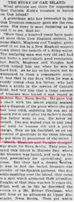
I'm referring to a post about 5-6 back showing a newspaper article about a man on his death bed giving the original 3 a treasure map that his dad supposedly gave him years earlier...
This is actually the first I have heard of the original 3 having a map to go by instead of one of them coming across the depression in the ground under the tree etc....
 

freeman

Sr. Member
Apr 5, 2003
346
665
No 1. You never referred to the origin story being reported in contemporaneous articles or accounts, yet there they are. Nor did they ever speak of anywhere or other treasures other than what was taken from the map or information they were using. To somehow they now suggest otherwise is false. 2. Various copies of the map used can be found being used in other locations and do appear in other stories. A simple comparison of those locations reveal the same plottings and dimensions described being used. You might want to do that exercise for Haute Island and the searches conducted there.There is an easily found article where even the reporter comments how it's the same treasure being searched for on both islands. You might want also to use that exact map image and check the locations of the various shafts still bring sunk (C1, Gal 8 etc) on the island. Then also take Robert Restalls own survey and see what lines he was using from it also.
 

Top Member Reactions

Users who are viewing this thread

Top