Four Native American Villages 1805 map and today.

Kansasippi

Jr. Member
Nov 26, 2006
60
3
Delphos
Detector(s) used
Prizm IV,ML 18000,Tesoro Inca,Black Widows
In the limited experience I have had, I found that camps were of several types. I have hunted an area that was occupied by people who had 'high' water and 'low' water camps.

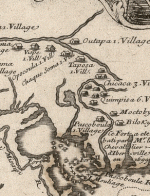
I would at least entertain searches in the areas you suggest, as I agree with the turning the map it does resemble the topo of today, and keep an eye out for high ground near one of your suspect spots. Hopefully there will be a plowed feild nearby and after a rain you may find some points exposed.

Just a thought.....
 

eddiebhome

Greenie
Jun 5, 2005
16
0
Clay, Alabama
Detector(s) used
Whites XLT-e
Primary Interest:
All Treasure Hunting
Interesting discussion.  Why does there appear to be a very faint mirror image of the river course, text, etc. appearing in the background of the old map?

Just curious.
 

Davisdog

Jr. Member
Jul 18, 2006
63
12
Spanaway, WA
Detector(s) used
Discovery 3300
Look at the fold marks on the old map. The faint mirror images hame to be from when the map was folded on itself.
 

Tricia

Hero Member
Mar 5, 2007
594
8
Was part of an archaeological survey that found a village on the bend of a river. You would not have found it by searching the surface. No satellite image or even walking through the farm fields would have given you a clue. You have to dig.

Ask the farmers if they have ever discovered something while preparing the land.

It's also been my experience that metal artifacts only go to a certain time period. Depending on the date of the village you'd expect to find traded goods in metal. But prior to that the tools and daily use items are made of natural materials.

Whatever you do, get permission to be out there exploring. Be a guardian of the past.

Good luck.
 

RELICDUDE07

Bronze Member
Oct 2, 2007
2,128
54
Pascagoula Ms.
Detector(s) used
minelab exp.
This may also be a good area close to ya Dg39 :)
 

Attachments

  • map_imageCA0MNBZD.gif
    map_imageCA0MNBZD.gif
    117.8 KB · Views: 2,286

Gold_Needle

Full Member
Jun 21, 2005
133
1
Have you tired turning the map over on its back and then lining it up? Like a reverse image

I think I see the river match up when you do that, at least on the left side.
 

OP
OP
dg39

dg39

Bronze Member
Mar 30, 2006
1,869
37
Deep in the swamps of Louisiana..
Detector(s) used
Ace 250--White's 6000 DI Pro
Primary Interest:
All Treasure Hunting
An interesting note to this. The first railroad west of the Mississippi and the second railroad in the United States went along the general line of this bayou in 1835 . Ralph Smith Smith (two last names) established this railroad to convey cotton and sugar cane from the large plantations to a port on the Red River at Alexandria, La. During the early part of the Civil war a Union report said that an antique steam engine was pushed into the bayou pictured.
(around 1863-4) It was never recovered. So some where in that twisting bayou lies the second commercial steam engine to run in the United States. Interesting isn't it?
I haven't been able to search the area because most of my time has been involved in writing a book that just got published.
I did visit a plantation home about 50 yards from the bayou and near one of the villages. The owner reported finding points and pottery shards in the woods over the years. So little time, so much to do.
Adding another point. This area contained the richest farm land in the south and some of the most interesting land owners of the early to mid 1800's. The land of the Dix.
Oh, and another thiing. Jim Bowie lived near here in 1817. I have records from an old trading post where he purchased a pen knife some tobacco and a hankerchief.. The whole area is loaded with history.

DG
 

A. Grignon

Full Member
Oct 9, 2007
176
14
Wisconsin
Detector(s) used
Whites XLT & Whites Beachhunter
Way to go on the research. If I were you I would run a metal detector wide open over that area.
You never know what you will find.
Here is stuff that was found by doing research on a old village from the 1830's.
 

Attachments

  • DSC00832.JPG
    DSC00832.JPG
    81.5 KB · Views: 1,790
OP
OP
dg39

dg39

Bronze Member
Mar 30, 2006
1,869
37
Deep in the swamps of Louisiana..
Detector(s) used
Ace 250--White's 6000 DI Pro
Primary Interest:
All Treasure Hunting
AG
I found a U.S. Militia button similar to yours about ten miules from the above map area and across the red river. Figured it belonged to a Battle of New Orleans veteran.
DG
 

New Orleans Relic

Sr. Member
Jul 17, 2012
433
132
New Orleans burb
Detector(s) used
At-Pro, Fisher F2
Primary Interest:
All Treasure Hunting
Is this the end of the story Dig39? I was so intrigued, and then..............
Almost 5 years now. Tell us of the expeditions, we were sure to come!
 

45th_Johnny

Hero Member
Jul 14, 2017
622
1,122
Mississippi
Primary Interest:
All Treasure Hunting
Indians, I live on an old mound. Let me tell you a story. "In the beginning God created the heavens and Earth..." At one time the earth was covered in water. Volcanic actions created the mountain ranges. On what is now the North American continent The Appalachian Mountains were first and have been worn down and folded. as the water receded only the tops of mountains were visible. Fast forward to a thousand years ago: Anyone alive would have been at the top of what is now hills. All of the hills near water at one time or another had Indians living there at one time or another. My house is approximately 290 feet above sea level at the high point. Going out from the center about a hundred feet is another rise that probably circled the top. I say probably because the land was farmed and a road was paved through it, but you can still see the circular rise running around the mound. My brother lived on a mound and only from the air one could see it resembled an animal read, some say horse I saw deer.

Anyway Indians needed water for drinking, a place to stay dry and water to travel on. There were hunting trails, which may have become roads, but water was a means for the Indians to trade over long distances. Look for elevation and nearby water.

Enjoy the hunt,

Johnny
 

45th_Johnny

Hero Member
Jul 14, 2017
622
1,122
Mississippi
Primary Interest:
All Treasure Hunting
If you live in New Orleans, I guess you know about all the Indian sites in your area. Most are in the eastern part on Orleans Parish into St. Tammany and St. Bernard, you would need a boat to get to most of them.

Johnny
 

Last edited:

Top Member Reactions

Users who are viewing this thread

Latest Discussions

Top