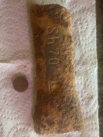
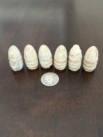
Four Native American Villages 1805 map and today.

dg39

Bronze Member
Mar 30, 2006
1,869
37
Deep in the swamps of Louisiana..
Detector(s) used
Ace 250--White's 6000 DI Pro
Primary Interest:
All Treasure Hunting
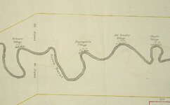
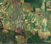
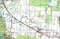
Found this old map 1805 date. No north or south orentation on it. Shows four villages on Bayou Boeuf between Alexandria, La and Cheneyville, La. My eyes cant find these curves on a Google map of aprox. the same territory, can you possibly help. Have enclosed both. Should be able to at least pinpoint where these villages are today.
A good distance referance is the 40 Arpens line on either side of the map. That should give aprox. scale.
I'm still looking myself, but so far no luck. It could be further south or above Alexandria to the North, I dont know.
Thanks!
DG
 

Attachments

  • rapides parish map three.jpg
    rapides parish map three.jpg
    44.1 KB · Views: 5,671
  • Bayou Boeuf.jpg
    Bayou Boeuf.jpg
    166.9 KB · Views: 5,890

aa battery

Gold Member
Oct 11, 2006
10,620
3,241
🏆 Honorable Mentions:
1
Primary Interest:
All Treasure Hunting
Cant wait for the rest of the story.
 

JT

Full Member
Mar 14, 2005
202
52
Johns Island, South Carolina
That river channel could have changed tremendously from the early 1800's to now. My advice would be to find other maps from between then and now, and try to figure out how much movement the channels have had.
 

jlewisk

Jr. Member
Apr 4, 2005
44
1
Alabama
Detector(s) used
Garrett AT Pro
Garrett Pro Pointer
Whites MXT
I think that maybe here are some of the locations. Check near the inlets of other streams or rivers.
 

Attachments

  • rapids parish map.JPG
    rapids parish map.JPG
    183.1 KB · Views: 5,311

gord

Hero Member
Mar 30, 2005
529
41
London, ON
Would they have been palisaded? Centered @ 31 02 57, -92 20 35 there is a vague outline of a "reverse 'D'", with a trench SSW-NNE between the upper right and lower left 'corners' that might represent Beluxie. One question on the original plat regards the use of 'arpen' as a measure of length - it was an area measure, about 7/8 acre.
Gord

<<Just remembered part of an old poem "de scow bus' up on lac St. Pierre, wan arpent from de shore" - so it's also a measure of length: 180 'pieds' (French 'foot' measure), or about 192'.>>
 

Davisdog

Jr. Member
Jul 18, 2006
63
12
Spanaway, WA
Detector(s) used
Discovery 3300
Am I the only one who sees it? Compare the left side of the 1805 map to the left side of the google map (but turn the 1805 map upside down.)
 

EDDE

Gold Member
Dec 7, 2004
7,129
65
Detector(s) used
Troy X5
Primary Interest:
All Treasure Hunting
Davisdog said:
Am I the only one who sees it? Compare the left side of the 1805 map to the left side of the google map (but turn the 1805 map upside down.)
bingo ;D
 

gord

Hero Member
Mar 30, 2005
529
41
London, ON
Davisdog said:
Am I the only one who sees it? Compare the left side of the 1805 map to the left side of the google map (but turn the 1805 map upside down.)
I tried that earlier as well - fits the river a little better than top/north, but for the most part would put the village sites in the swamp. Also doesn't fit the 'Bayou Boeuf' label location.
Gord
 

starsplitter

Sr. Member
Jan 20, 2007
434
31
Really interesting! An idea... the course of the river may have changed significantly over the years. Don't know... but, is there a satellite imaging system (or other) that could reveal the old course (if it has changed)? I've seen such pics, but don't know what the technology is called.
 

T.L.McGee

Newbie
Jan 31, 2007
1
0
Hi all...my first post on here! I was thinking that if it is a very slow moving river it might still be in the original formation.

Terry
 

OP
OP
dg39

dg39

Bronze Member
Mar 30, 2006
1,869
37
Deep in the swamps of Louisiana..
Detector(s) used
Ace 250--White's 6000 DI Pro
Primary Interest:
All Treasure Hunting
Have been away for a while. It is a bayou or very slow moving stream, so the change in channell would be next to nill in my mind. I have to wait for warmer weather to go out and also have to get permission from property owners to hunt.
So that should take a while.
DG
 

D

Doon

Guest
Being a former archaeologist I have a little experience reading old maps and how rivers change course over time... Looking at the two maps I see very little similarity. 200 years is a VERY long time! The river has no doubtedly changed extensively over the years. Larger rivers have moved up to a mile in shorter amounts of time. Also, if the area is in a flood plain, or has EVER flooded the silt layers could be many feet thick..... Here in Missouri there are hundreds of Riverboats that sunk in the mid 1800's along the missouri and mississippi. They are now normally located up to a mile away from the original chanel at depths of 40-50 feet deep.....It's hard to believe that the elevations and river chanels can change that much in such a seemingly short amount of time...but it's true...
 

Noodle

Bronze Member
Jul 20, 2005
2,278
35
N Louisiana
Detector(s) used
Ace 250
I live in Louisiana and work for an organization that has a lot of interest in swamps, rivers, lands, etc. In the early 20th century, the bayous were dredged and straightened out in several places in the state. One on my property was "moved" over about 50 feet to the west. It used to be a half mile wide; now it's only 10 feet wide, but the main old channel can still be found in my woods, and it holds water very well in the winter and springtime. Bayou Lafourche, which is 15 miles from my place, is a huge bayou. Some might want to call it a river. But in truth, it's just a big dugout canal which is hardly representative of what it was in the 1800s. Boeuf River runs just to the east of Lafourche about 5-7 miles, but is much smaller now. It wasn't dug out, but its waters were diverted into the Lafourche, changing its whole complexion. In some areas from aerial photographs, and even GoogleEarth, you can see where real crooked, snakey rivers were redug and straightened out. You can see the little cutoff areas off to the side of the river or bayou, which left "c-shaped" lakes on both sides of the main body of water.

On the other hand, the places with Indian names have been documented since the 1700s. That may be your best bet in your research. (The Biloxi Indians were in south Louisiana and Mississippi.) Keep looking; Louisiana state sites have a lot of Native American information on them. Do a search for "Indians in Louisiana" through Google or Alta Vista and several sites will pop up for you. Good luck.

- Noodle
 

kevo

Sr. Member
Mar 2, 2007
417
1
Louisville, Kentucky
I didn't have time to see if u got a definate answer yet but the old version looks backwards from the new version, may be possible that it was drawn out that way????
 

H

HeavyD

Guest
If you flip the original 1800's map horizontally and then flip it vertically, I think that you will find that this "new" view of the map matches a portion of the river that was cut off
from the left side of the google map (except for the "thumb" looking bend in the river) WHEW..... Is that as confusing as it sounds?
I will attempt to attach the new maps which I have labeled....
Good Luck!
ORIGMAPF2.JPG
RIVERF2.JPG
 

OP
OP
dg39

dg39

Bronze Member
Mar 30, 2006
1,869
37
Deep in the swamps of Louisiana..
Detector(s) used
Ace 250--White's 6000 DI Pro
Primary Interest:
All Treasure Hunting
HeavyD said:
If you flip the original 1800's map horizontally and then flip it vertically, I think that you will find that this "new" view of the map matches a portion of the river that was cut off
from the left side of the google map (except for the "thumb" looking bend in the river) WHEW..... Is that as confusing as it sounds?
I will attempt to attach the new maps which I have labeled....
Good Luck!
I think thats the way to look at it. I am going to search in those areas.
Thanks for your input, All!
DG
 

xdanthemanx

Sr. Member
Oct 25, 2007
361
56
clarkston michigan
Detector(s) used
E-trac & XLT
aww comon you guys, your comparing a hand drawn map with a precise arial photo, it of course is NOT going to match perfectly , either way you could walk to any of those sites in a short time if you can get access legally. i see a canoe trip coming up

dan
 

RELICDUDE07

Bronze Member
Oct 2, 2007
2,128
54
Pascagoula Ms.
Detector(s) used
minelab exp.
it does look like a fun canoe trip it was a guess from the names of the villages ?they are towns in mississippi today :) maybe it is in louisiana :-X
 

Top Member Reactions

Users who are viewing this thread

Top