gazmuth
Jr. Member
- Jun 16, 2012
- 41
- 14
- Detector(s) used
- Minelab CTX 3030, Garret GTX 500
- Primary Interest:
- Metal Detecting
I am chasing out a lead, and so I am looking for the approximate location of Camp Holmes, which became Fort Holmes in about 1870. Here is what I am working with:
"The regiment left Jefferson Barracks at Saint Louis, October 27, 1855, the whole ten companies being together and numbering over seven hundred fifty men and eight hundred horses. Traversing southwestern Missouri it passed through Springfield and Neosho, down the boundary line of Missouri to Maysville, and thence through Indian Territory to Tahlequah. From there it marched to Fort Gibson; crossing Grand and Arkansas rivers it must have passed over the site of the future Muskogee; on December 4, it crossed the North Fork of Canadian River and, the next day, forded the Canadian, probably near Old Fort Holmes, at the mouth of Little River. It reached Fort Washita on December 21, and, on the fourteenth, crossed Red River into Texas and proceeded on to Fort Belknap."

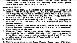
Now my question is, for the little round dot looks to me to be right in the middle of where Little River and the Canadian River is converging, so I take out the county map that I have to look at the way it appears presently:

So I am thinking that Camp/Fort Holmes was likely in the area where I have placed the Red Rectangle? There is a cemetery right there, chances are that it was from the old fort? Or, in about 1885 there was a small town called 'Bilby' there, it is on another map I have. Or perhaps, since the people who have 'Edwards Trading Post' according the dialogue I placed in the front he Chronicles, the cemetery was from the store, for travelers would come to a spot on a trail, maybe have dead or wounded, and need to bury them?
"At Camp Holmes a firm of traders, known as Edwards and Shelton, was licensed to trade with the Indians and, for years, the place was known as Edwards’s Settlement. Edward’s daughter was married to Jesse Chisholm, a halfbreed Cherokee and a famous guide and scout, who also lived there. A well used trail to Camp Holmes stretched southwest across Pontotoc, Murray, Carter, and Jefferson counties and crossed Red River at the mouth of Beaver Creek, where Ryan now is."
So, this is an interesting site for me, I thought I would share some of the research on this rainy day with others, and thought maybe someone else could help me a little bit with perhaps their knowledge of the area before I drive the 150 miles down there to began trying to find who owns the land, if they will allow me to check it out, and hopefully do some metal detecting. But it is helpful o figure out where the fort was, the trading store, and where exactly the old ford or crossing was located, all of which I no doubt will have to venture out to find on my own.
Thanks to all in advance.
Gazmuth
"The regiment left Jefferson Barracks at Saint Louis, October 27, 1855, the whole ten companies being together and numbering over seven hundred fifty men and eight hundred horses. Traversing southwestern Missouri it passed through Springfield and Neosho, down the boundary line of Missouri to Maysville, and thence through Indian Territory to Tahlequah. From there it marched to Fort Gibson; crossing Grand and Arkansas rivers it must have passed over the site of the future Muskogee; on December 4, it crossed the North Fork of Canadian River and, the next day, forded the Canadian, probably near Old Fort Holmes, at the mouth of Little River. It reached Fort Washita on December 21, and, on the fourteenth, crossed Red River into Texas and proceeded on to Fort Belknap."
Now my question is, for the little round dot looks to me to be right in the middle of where Little River and the Canadian River is converging, so I take out the county map that I have to look at the way it appears presently:
So I am thinking that Camp/Fort Holmes was likely in the area where I have placed the Red Rectangle? There is a cemetery right there, chances are that it was from the old fort? Or, in about 1885 there was a small town called 'Bilby' there, it is on another map I have. Or perhaps, since the people who have 'Edwards Trading Post' according the dialogue I placed in the front he Chronicles, the cemetery was from the store, for travelers would come to a spot on a trail, maybe have dead or wounded, and need to bury them?
"At Camp Holmes a firm of traders, known as Edwards and Shelton, was licensed to trade with the Indians and, for years, the place was known as Edwards’s Settlement. Edward’s daughter was married to Jesse Chisholm, a halfbreed Cherokee and a famous guide and scout, who also lived there. A well used trail to Camp Holmes stretched southwest across Pontotoc, Murray, Carter, and Jefferson counties and crossed Red River at the mouth of Beaver Creek, where Ryan now is."
So, this is an interesting site for me, I thought I would share some of the research on this rainy day with others, and thought maybe someone else could help me a little bit with perhaps their knowledge of the area before I drive the 150 miles down there to began trying to find who owns the land, if they will allow me to check it out, and hopefully do some metal detecting. But it is helpful o figure out where the fort was, the trading store, and where exactly the old ford or crossing was located, all of which I no doubt will have to venture out to find on my own.
Thanks to all in advance.
Gazmuth