Gypsy Heart
Gold Member
http://www.chrisanddavid.com/caddo/index.shtml
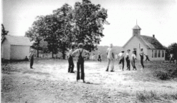
There are two so-called "wire roads" in Webster County, Missouri, and the ghost town of Caddo, MO, is located on the lesser known of the two. Once a thriving little community, nothing remains to prove there was ever a town at the intersection of State Highway DD and County Road J. The photo above is the Caddo school house, known as the Bodenhamer school, taken sometime between 1831-1836. It too has disappeared.
My research has discovered very little of the town and residents of Caddo, Missouri - but will be included as it comes available.
Post Office - 1891-94, 1898-1906
37.°20'31" N 93°2'49" W
Section 29 Township 30N Range 19W
Elevation = 1317
Grant Township, Webster County, Missouri
The Wire Road
I know little about the "original" wire road of Webster County, and I hope to learn more as I meet others who have researched the history of the trail. I became interested in this old wilderness road when a Caddo neighbor advised me that the southeast corner of my property bordered the wire road. This was contrary to the general history which I could find, which clearly stated the Wire Road in Webster County generally followed Old Route 66 (known as Bloody 66), which, in Webster County, runs fairly parallel to its replacement, Interstate 44. But the locals of this area were very adamant, the Wire Road ran thru Caddo. So I began to research.
One of the earliest written examples I found of a wire road in this general area was a Civil War memoir. In the Battle of Springfield in January 1863, Confederate General Marmaduke attacked, but was unable take Springfield from Union control. The next day his force moved eastward along the Wire Road. "At 10 o'clock on the morning of the 9th, Marmaduke's command was well out on the wire road leading to Rolla, seeking to join forces with Col Porter. At Sand Springs the advance of Porter was met and a halt was made. Here the prisoners were all paroled and sent back, and the united command began to retreat eastward by way of Marshfield and Hartville." Sand Springs is located directly northeast of Caddo, and had a post office from 1863-1875, and from 1877-79. It is also nowhere near what is accepted as THE wire road in Webster County.(Sand Springs was the site of a Union fort which fell easily and was destroyed by Marmaduke, as was Marshfield. The fort at Hartville was stiffly resisted, but fell and met the same fate). Interestingly, all three of these forts sat on major trails.
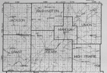
For the remainder of this article, the well known wire road that travels thru Marshfield shall be referred to as Wire Road 2, while the road of this article shall be called Wire Road 1**. The reason for these numbers will become clear as I attempt to prove that long before Wire Road 2 became popular by the railroad, Wire Road 1 was a major southwest trail used by settlers as they moved west from St Louis. Wire Road 2 follows what is known as the Ozark Highlands thru Webster County. To the north of this ridge, rivers flow north, and to the south of the ridge, they flow southward. This ridge offered many advantages to railroad builders, allowing them to bypass the numerous springs and rivers that dotted the land slide, and offering less hills to master than the surrounding countryside demanded. With the completion of the railroad, Webster County experienced a major population shift toward the lines. This would spell the eventual doom for many small towns, including some on the smaller map above. Included among these would be St Mark, located above the letter W in Webster.
St Mark was one of the older towns of Webster County, showing a post office open in 1857 and closing in 1860, one year before the outbreak of the Civil War. One of its churches would be destroyed during that war. St Mark would die out and today, nothing remains to prove its exact location. However, we do know it sat directly on Wire Road 1. On this same map, we also see the former town of St Luke. St Luke, although no longer an incorporated town, still remains a community in northern Webster County. Between St Mark and St Luke, sat the town and fort of Sand Springs, and in the latter 1800's and early 1900's, Caddo.
.
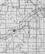
In the below 1930 map of northern Webster County, we see the St Louis-San Francisco Railroad moving from north central part of the map south to Niangua, then southwest thru Marshfield and Northview into Greene County, Missouri. By now old wire road's, and Indian traces had been replaced by dirt county roads. Wire Road 1 can be followed starting just north of the southwest corner of the map, traveling north, northwest thru Caddo, then Old Fort Sand Springs, near Beach, St Luke, and finally Forkners Hill.
Drawing a straight line from Springfield to Rolla, takes you right along where Wire Road 1 sits. Thus, for the early traveler, the "quicker" way would appear to be Wire Road 1. However, the topography was much rougher than the Ozark Highlands and flooded streams and rivers, could easily negate the straighter advantage. Thus, by the time of the railroad and the Civil War, Wire Road 1 was no longer the primary route of travel thru Webster County.
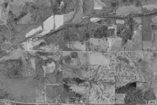
Below is a satellite photo of Caddo in which remnants of wire road 1 can still be seen. Caddo sat around the T junction in the middle of the photo. This T of dirt roads has been replaced by paved Highway DD (to the east)curving into J Road (to the south). The stretch of road leading to the west remains gravel to this day.
Research- this is an active research project for me, as I have time, and I am very interested in speaking to anyone who has information about Caddo or the Old Wire Road. If you have any information, or have photo's you would like to share, please e-mail me. E-mail David
**Please note - while I call this trail Wire Road 1, I have been unable to find proof there was ever any telegraph wires strung along this section before, during, or after the Civil War. On the other hand, there is clear evidence the trail thru Marshfield, called Wire Road 2 in this article, was used for telegraph, and this, got the nickname "Wire Road". I am still looking.
Also, I am discovering that much that is 'known' about Wire Road 1, is from stories that have passed down thru generations and thus has become tainted with innocent errors, or exaggerations, that are now accepted as the gospel truth.
Post Office openings in Webster County (courtesy Missouri Postal History Society)
Towns of Wire Road #1
Saint Luke - 1858-1862
Beach - 1897-1906
Sand Springs - 1863-1875, 1877-1879
Caddo - 1891-1894, 1898-1906
Saint Mark - 1857-1860
Towns of Wire Road #2
Sampson - 1904-1935
Marshfield - 1856-Present
Northview - 1873-1876, 1880-1973
--------------------------------------------------------------------------------
Information provided by Lindel Snider of Marionville who has researched old Southwest Missouri trails for years....
From 'Highlights in Webster County History'
page 3 - "The Federal Government had established a road from Rolla, Missouri to Fort Smith in the Arkansas Territory in 1838, more of less following old Indian trails. This road ran diagonally across what would later become Webster County in a northeast to southwest direction. This road would later be called at various times and by different generations the military road, the telegraph road, the St. Louis to Springfield road and the wire road."
page 127 - Route U. S. 66, originally planned to follow the wire road across Webster County, taking it through Forkner?s Hill, St. Luke, Sand Springs and Caddo was re-routed by way of Sampson, Niangua, Marshfield, Northview and Holman. This change was made in the last reading of the bill in the state legislature. The road will now more or less parallel the railroad across the county.? (This was in the 1920?s) In 1941 the state announced a plan to move Highway 66 north of Marshfield along the route followed by the Old Wire Road, but was protested and rejected."
According to records early settlers came along this general route to Webster and Greene County in 1829 and the early 1830?s, following the old Indian trails. Following a trail with no name into the wildness.
The military road established in 1838 from St. Louis to Ft. Smith, considering the hills, terrain and rivers of the area of southern Missouri and northern Arkansas, would have provided the best overland route for troops, wagons and supplies traveling to and from the Indian Territory. The Arkansas River furnished a water route to Ft. Smith, but this Military Road across southern Missouri provided an overland route to the area.
The St. Louis to Springfield Road:
When Springfield was established and more and more settlers and freight wagons used this road, it became known as the St. Louis Road. For the most part, it depended on which end of the road you were at, as to what it was called. If you were at St. Louis, it was the Springfield Road, from Springfield to Ft. Smith it was the Ft. Smith Road, but later became known as The Fayetteville Road.
There was the Boonville Road, which was also, became known as The Bolivar Road, or from these towns to Springfield, known as the Springfield Road, and so on with the other trails.
According to the Postal records there was apparently a stage route that followed the St. Louis Road.
The Telegraph Road:
In 1862 with the outbreak of the Civil War and the problems in Missouri there was a push to get the Telegraph put through from St. Louis to Springfield, making a connection between St. Louis and Ft. Smith. The most likely route would have been along the road most used at that time and was used by the military to and from Ft. Smith. Also, the roads at that time that ran from Conway through Marshfield to Strafford, zigzagged through the country. Also, it is stated that the Telegraph line ran along a road near Marshfield.
Also, I found a piece that had been torn from an old news paper pertaining to the Old Wire Road, (no date). It says their father, Thom L. Wood had a store at Lebanon during the Civil war and mentions the one wire that ran along the road from Rolla to Springfield, which at that time would have been the Telegraph wire.
This route for the telegraph would most likely only been for about a 10 year period from about 1862 to 1872, then being moved to follow the railroad.
The Old Wire Road:
Having gone by many names when the many telephone wires ran along this road is when it became well known to people throughout the area as the Old Wire Road. It may have earlier been called the Old Wire Road, or Telegraph Road, but the telephone wires brought it to the name known as the Old Wire Road, and is still called that by many of the older people of the area to this day.
Mr Snider can be contacted at [email protected]
--------------------------------------------------------------------------------
More info from Mr Snider
As for The Old Wire Road, before Springfield became a town in the 1830’s, it was basically an old Indian trail or trails. Springfield was first known as, Stump Town.
I am sure there were places along the old trail that the early settlers had to make some deviations from the old Indian trails to be able to cross streams and access hills with their wagons.
When Springfield became a town, the Road became known as The St. Louis Road. At times some may have referred to it as the, Military Road, Wire Road or Telegraph Road, but the common name and most used was, The St Louis Road.
From what I have been able to find, about 1878 is when telephone lines begin to go up along the road from St Louis to Springfield. By 1900 or shortly after there were several telephone wires on the poles along the St Louis Road. About this time is when the people through the area begin to call it, The Old Wire Road. This name stuck and the name St Louis Road was dropped. By 1950, there were many cross-arms on these poles and many telephone wires on each cross-arm. Then in the 1950’s the wires and cross-arms begin to come down, but for all of those that knew this old road, it still was called, The Old Wire Road. Many of the articles that were written after around 1900 usually referred to it as, The Old Wire Road.
Many of the military coming into the area during the Civil War, especially the Southern Army, would not have known the name of the road and most likely referred to it as, The Wire Road because of the telegraph line.
Like I have said many of the old maps are not reliable as to showing the route through the hills that many of these old roads took. I base most of my information on them from bits and pieces of info from old letters and articles that were written in the 1800’s and people that I knew that were born back in the 1800’s, of which I knew many. For example, my Grandfather Floyd Snider was born in 1883, which he told me what his Grandfather had told him about what the area was like when the Snider family came to Greene County in 1843 from North Carolina. Great-Great Grandpa Alexander was 17, when they came. My Bass relatives came in 1830. I have a copy of a letter written in 1844 by Paschal Minor in North Carolina to his son Augustine Minor. Augustine was in the group with the Snider’s that came in 1843; Augustine settled about a mile north of Caddo. Where Augustine settled was mostly prairie at that time.
Here is a piece that I think is interesting and also gives info on the St Louis Road.
From a copy of the land record I have on the Mt Pisgah Cemetery.
Commencing at the half mile corner between Sections Seventeen (17) and Eighteen (18) and running North Thirty-nine Chains to a Cotton Rock in the St. Louis Road; Thence in a South West direction with the St. Louis Road Seven Chains and fifteen Links to a Cotton Rock, Thence South Thirty-three Chains and Thirty-three Links to a Cotton Rock, Thence East five Chains to the beginning, Containing Four Acres & one half and acre, more or less, in Section (18) Eighteen, Township Thirty, of Range Nineteen.
The above described land to be held by Fredrick V. Goss, Wilson Merell, and Nicholas Rhodes (Trustees) and their successors) for a Public Burying Ground.
Land was sold by James A Grier and Candace S. Grier, his Wife.
Sum of, Forty-Five Dollars.
Date: August 30, 1871.
In 1888 Grandpa Wilson and Grandma Sarah Bass donated the land for the Mt. Pisgah Church. I also have a copy of that land record.
Very early on there was a trail that went north from the Webster County area to Linn Creek on the Osage River up by Camdenton; this is where many of the early settlers went to the trading post. (This was Old Linn Creek, not the present Linn Creek.) Even after a store was put in at Springfield, many still went to Linn Creek for some time, it being on the Osage River where supplies were brought up the river from the Missouri River, most likely a better stock of goods and cheaper prices.
The trail to Linn Creek connected with the Jefferson trail in the Linn Creek area.
Early on there was a trail that came from Rolla to Grovespring in Wright County, then west to Niangra, then southwest to what became Marshfield, then southwest along the Turnbo Creek to the James River, where it connected with the old Hartville trail.
Many took the trail from Marshfield down the Turnbo to the mill on James River.
John Cardwell was one of the earliest settlers in what became Webster County. Early on he helped layout the trail that ran from Marshfield to Sand Springs, on to Elkland then west across southern Polk County to the Boonville Road, which ran from Springfield through Bolivar and on to Bonnville; this trail out of Webster County was called the Bolivar Road. The area being open large timber and prairie, it was not a matter of cutting a trail but, finding a route which wagons could travel. It was staked out and then as wagons begin to travel along this route, it became a road. This was the case for many of the local trails through the area. With time these old trails were rerouted in many places, some just disappeared over the years.
John L. Melton had the store and post office at Caddo around 1900.
In 1800, Spain turned over the land known as Louisiana (much of the south central US west of the Mississippi River) to France. In 1803, France sold this land to the United States for $15 million dollars in what would be known as the Louisiana Purchase. The US then discovered that, thanks to a 1541 Desoto treaty with the 6 Bulls Indian Confederation, much of this land could not be homesteaded. So in 1808, the US made an agreement with the 6 Bulls to purchase the land. In 1809, the 6 Bulls rebelled, claiming the agreement was a lease only. The courts denied the Indian claim and the Indians declared war. This war would continue until 1828.
During this period, the 6 Bulls, primarily the Osage tribe, attempted to govern the area, but the US continued to divide it, first into upper and lower Louisiana. In 1812, lower Louisiana became a state and upper Louisiana became the Missouri Territory, which included the 6 Bulls Confederation to the north, and the Arkawas Indian Confederation to the south. Then in 1819, the Missouri Territory was divided into the Missouri and Arkansas Territory. In 1821, part of Missouri Territory, home to Colonel Daniel Boone's Northern Outpost (located in present day Christian County, Missouri) became the state of Missouri. In 1836, part of Arkansas Territory, home to Boone's central outpost, became the state of Arkansas.
Boone's outposts predated the 1808 US agreement with the 6 Bulls, and were operating under their own lease with the Indian's. With the 1808 treaty between the Osage and the US government, these agreements were forfeit and Boone would abandon the area, returning to Kentucky. While they operated, the Boone's outposts were central to camps (similar to today's counties), and in each camp, there were springs (small settlements). Union Camp was the entire Niangua River Basin, and the "springs" were primarily located near water and around deposits of minerals (salt petre used in processing gunpowder, lead for gunshot, and iron for cannon ball).
While I can not confirm at this point, I suspect the original Wire road was Spanish in origin, and this would explain the names of early county towns on this trail such as St Luke and St Mark.
There are two so-called "wire roads" in Webster County, Missouri, and the ghost town of Caddo, MO, is located on the lesser known of the two. Once a thriving little community, nothing remains to prove there was ever a town at the intersection of State Highway DD and County Road J. The photo above is the Caddo school house, known as the Bodenhamer school, taken sometime between 1831-1836. It too has disappeared.
My research has discovered very little of the town and residents of Caddo, Missouri - but will be included as it comes available.
Post Office - 1891-94, 1898-1906
37.°20'31" N 93°2'49" W
Section 29 Township 30N Range 19W
Elevation = 1317
Grant Township, Webster County, Missouri
The Wire Road
I know little about the "original" wire road of Webster County, and I hope to learn more as I meet others who have researched the history of the trail. I became interested in this old wilderness road when a Caddo neighbor advised me that the southeast corner of my property bordered the wire road. This was contrary to the general history which I could find, which clearly stated the Wire Road in Webster County generally followed Old Route 66 (known as Bloody 66), which, in Webster County, runs fairly parallel to its replacement, Interstate 44. But the locals of this area were very adamant, the Wire Road ran thru Caddo. So I began to research.
One of the earliest written examples I found of a wire road in this general area was a Civil War memoir. In the Battle of Springfield in January 1863, Confederate General Marmaduke attacked, but was unable take Springfield from Union control. The next day his force moved eastward along the Wire Road. "At 10 o'clock on the morning of the 9th, Marmaduke's command was well out on the wire road leading to Rolla, seeking to join forces with Col Porter. At Sand Springs the advance of Porter was met and a halt was made. Here the prisoners were all paroled and sent back, and the united command began to retreat eastward by way of Marshfield and Hartville." Sand Springs is located directly northeast of Caddo, and had a post office from 1863-1875, and from 1877-79. It is also nowhere near what is accepted as THE wire road in Webster County.(Sand Springs was the site of a Union fort which fell easily and was destroyed by Marmaduke, as was Marshfield. The fort at Hartville was stiffly resisted, but fell and met the same fate). Interestingly, all three of these forts sat on major trails.
For the remainder of this article, the well known wire road that travels thru Marshfield shall be referred to as Wire Road 2, while the road of this article shall be called Wire Road 1**. The reason for these numbers will become clear as I attempt to prove that long before Wire Road 2 became popular by the railroad, Wire Road 1 was a major southwest trail used by settlers as they moved west from St Louis. Wire Road 2 follows what is known as the Ozark Highlands thru Webster County. To the north of this ridge, rivers flow north, and to the south of the ridge, they flow southward. This ridge offered many advantages to railroad builders, allowing them to bypass the numerous springs and rivers that dotted the land slide, and offering less hills to master than the surrounding countryside demanded. With the completion of the railroad, Webster County experienced a major population shift toward the lines. This would spell the eventual doom for many small towns, including some on the smaller map above. Included among these would be St Mark, located above the letter W in Webster.
St Mark was one of the older towns of Webster County, showing a post office open in 1857 and closing in 1860, one year before the outbreak of the Civil War. One of its churches would be destroyed during that war. St Mark would die out and today, nothing remains to prove its exact location. However, we do know it sat directly on Wire Road 1. On this same map, we also see the former town of St Luke. St Luke, although no longer an incorporated town, still remains a community in northern Webster County. Between St Mark and St Luke, sat the town and fort of Sand Springs, and in the latter 1800's and early 1900's, Caddo.
.
In the below 1930 map of northern Webster County, we see the St Louis-San Francisco Railroad moving from north central part of the map south to Niangua, then southwest thru Marshfield and Northview into Greene County, Missouri. By now old wire road's, and Indian traces had been replaced by dirt county roads. Wire Road 1 can be followed starting just north of the southwest corner of the map, traveling north, northwest thru Caddo, then Old Fort Sand Springs, near Beach, St Luke, and finally Forkners Hill.
Drawing a straight line from Springfield to Rolla, takes you right along where Wire Road 1 sits. Thus, for the early traveler, the "quicker" way would appear to be Wire Road 1. However, the topography was much rougher than the Ozark Highlands and flooded streams and rivers, could easily negate the straighter advantage. Thus, by the time of the railroad and the Civil War, Wire Road 1 was no longer the primary route of travel thru Webster County.
Below is a satellite photo of Caddo in which remnants of wire road 1 can still be seen. Caddo sat around the T junction in the middle of the photo. This T of dirt roads has been replaced by paved Highway DD (to the east)curving into J Road (to the south). The stretch of road leading to the west remains gravel to this day.
Research- this is an active research project for me, as I have time, and I am very interested in speaking to anyone who has information about Caddo or the Old Wire Road. If you have any information, or have photo's you would like to share, please e-mail me. E-mail David
**Please note - while I call this trail Wire Road 1, I have been unable to find proof there was ever any telegraph wires strung along this section before, during, or after the Civil War. On the other hand, there is clear evidence the trail thru Marshfield, called Wire Road 2 in this article, was used for telegraph, and this, got the nickname "Wire Road". I am still looking.
Also, I am discovering that much that is 'known' about Wire Road 1, is from stories that have passed down thru generations and thus has become tainted with innocent errors, or exaggerations, that are now accepted as the gospel truth.
Post Office openings in Webster County (courtesy Missouri Postal History Society)
Towns of Wire Road #1
Saint Luke - 1858-1862
Beach - 1897-1906
Sand Springs - 1863-1875, 1877-1879
Caddo - 1891-1894, 1898-1906
Saint Mark - 1857-1860
Towns of Wire Road #2
Sampson - 1904-1935
Marshfield - 1856-Present
Northview - 1873-1876, 1880-1973
--------------------------------------------------------------------------------
Information provided by Lindel Snider of Marionville who has researched old Southwest Missouri trails for years....
From 'Highlights in Webster County History'
page 3 - "The Federal Government had established a road from Rolla, Missouri to Fort Smith in the Arkansas Territory in 1838, more of less following old Indian trails. This road ran diagonally across what would later become Webster County in a northeast to southwest direction. This road would later be called at various times and by different generations the military road, the telegraph road, the St. Louis to Springfield road and the wire road."
page 127 - Route U. S. 66, originally planned to follow the wire road across Webster County, taking it through Forkner?s Hill, St. Luke, Sand Springs and Caddo was re-routed by way of Sampson, Niangua, Marshfield, Northview and Holman. This change was made in the last reading of the bill in the state legislature. The road will now more or less parallel the railroad across the county.? (This was in the 1920?s) In 1941 the state announced a plan to move Highway 66 north of Marshfield along the route followed by the Old Wire Road, but was protested and rejected."
According to records early settlers came along this general route to Webster and Greene County in 1829 and the early 1830?s, following the old Indian trails. Following a trail with no name into the wildness.
The military road established in 1838 from St. Louis to Ft. Smith, considering the hills, terrain and rivers of the area of southern Missouri and northern Arkansas, would have provided the best overland route for troops, wagons and supplies traveling to and from the Indian Territory. The Arkansas River furnished a water route to Ft. Smith, but this Military Road across southern Missouri provided an overland route to the area.
The St. Louis to Springfield Road:
When Springfield was established and more and more settlers and freight wagons used this road, it became known as the St. Louis Road. For the most part, it depended on which end of the road you were at, as to what it was called. If you were at St. Louis, it was the Springfield Road, from Springfield to Ft. Smith it was the Ft. Smith Road, but later became known as The Fayetteville Road.
There was the Boonville Road, which was also, became known as The Bolivar Road, or from these towns to Springfield, known as the Springfield Road, and so on with the other trails.
According to the Postal records there was apparently a stage route that followed the St. Louis Road.
The Telegraph Road:
In 1862 with the outbreak of the Civil War and the problems in Missouri there was a push to get the Telegraph put through from St. Louis to Springfield, making a connection between St. Louis and Ft. Smith. The most likely route would have been along the road most used at that time and was used by the military to and from Ft. Smith. Also, the roads at that time that ran from Conway through Marshfield to Strafford, zigzagged through the country. Also, it is stated that the Telegraph line ran along a road near Marshfield.
Also, I found a piece that had been torn from an old news paper pertaining to the Old Wire Road, (no date). It says their father, Thom L. Wood had a store at Lebanon during the Civil war and mentions the one wire that ran along the road from Rolla to Springfield, which at that time would have been the Telegraph wire.
This route for the telegraph would most likely only been for about a 10 year period from about 1862 to 1872, then being moved to follow the railroad.
The Old Wire Road:
Having gone by many names when the many telephone wires ran along this road is when it became well known to people throughout the area as the Old Wire Road. It may have earlier been called the Old Wire Road, or Telegraph Road, but the telephone wires brought it to the name known as the Old Wire Road, and is still called that by many of the older people of the area to this day.
Mr Snider can be contacted at [email protected]
--------------------------------------------------------------------------------
More info from Mr Snider
As for The Old Wire Road, before Springfield became a town in the 1830’s, it was basically an old Indian trail or trails. Springfield was first known as, Stump Town.
I am sure there were places along the old trail that the early settlers had to make some deviations from the old Indian trails to be able to cross streams and access hills with their wagons.
When Springfield became a town, the Road became known as The St. Louis Road. At times some may have referred to it as the, Military Road, Wire Road or Telegraph Road, but the common name and most used was, The St Louis Road.
From what I have been able to find, about 1878 is when telephone lines begin to go up along the road from St Louis to Springfield. By 1900 or shortly after there were several telephone wires on the poles along the St Louis Road. About this time is when the people through the area begin to call it, The Old Wire Road. This name stuck and the name St Louis Road was dropped. By 1950, there were many cross-arms on these poles and many telephone wires on each cross-arm. Then in the 1950’s the wires and cross-arms begin to come down, but for all of those that knew this old road, it still was called, The Old Wire Road. Many of the articles that were written after around 1900 usually referred to it as, The Old Wire Road.
Many of the military coming into the area during the Civil War, especially the Southern Army, would not have known the name of the road and most likely referred to it as, The Wire Road because of the telegraph line.
Like I have said many of the old maps are not reliable as to showing the route through the hills that many of these old roads took. I base most of my information on them from bits and pieces of info from old letters and articles that were written in the 1800’s and people that I knew that were born back in the 1800’s, of which I knew many. For example, my Grandfather Floyd Snider was born in 1883, which he told me what his Grandfather had told him about what the area was like when the Snider family came to Greene County in 1843 from North Carolina. Great-Great Grandpa Alexander was 17, when they came. My Bass relatives came in 1830. I have a copy of a letter written in 1844 by Paschal Minor in North Carolina to his son Augustine Minor. Augustine was in the group with the Snider’s that came in 1843; Augustine settled about a mile north of Caddo. Where Augustine settled was mostly prairie at that time.
Here is a piece that I think is interesting and also gives info on the St Louis Road.
From a copy of the land record I have on the Mt Pisgah Cemetery.
Commencing at the half mile corner between Sections Seventeen (17) and Eighteen (18) and running North Thirty-nine Chains to a Cotton Rock in the St. Louis Road; Thence in a South West direction with the St. Louis Road Seven Chains and fifteen Links to a Cotton Rock, Thence South Thirty-three Chains and Thirty-three Links to a Cotton Rock, Thence East five Chains to the beginning, Containing Four Acres & one half and acre, more or less, in Section (18) Eighteen, Township Thirty, of Range Nineteen.
The above described land to be held by Fredrick V. Goss, Wilson Merell, and Nicholas Rhodes (Trustees) and their successors) for a Public Burying Ground.
Land was sold by James A Grier and Candace S. Grier, his Wife.
Sum of, Forty-Five Dollars.
Date: August 30, 1871.
In 1888 Grandpa Wilson and Grandma Sarah Bass donated the land for the Mt. Pisgah Church. I also have a copy of that land record.
Very early on there was a trail that went north from the Webster County area to Linn Creek on the Osage River up by Camdenton; this is where many of the early settlers went to the trading post. (This was Old Linn Creek, not the present Linn Creek.) Even after a store was put in at Springfield, many still went to Linn Creek for some time, it being on the Osage River where supplies were brought up the river from the Missouri River, most likely a better stock of goods and cheaper prices.
The trail to Linn Creek connected with the Jefferson trail in the Linn Creek area.
Early on there was a trail that came from Rolla to Grovespring in Wright County, then west to Niangra, then southwest to what became Marshfield, then southwest along the Turnbo Creek to the James River, where it connected with the old Hartville trail.
Many took the trail from Marshfield down the Turnbo to the mill on James River.
John Cardwell was one of the earliest settlers in what became Webster County. Early on he helped layout the trail that ran from Marshfield to Sand Springs, on to Elkland then west across southern Polk County to the Boonville Road, which ran from Springfield through Bolivar and on to Bonnville; this trail out of Webster County was called the Bolivar Road. The area being open large timber and prairie, it was not a matter of cutting a trail but, finding a route which wagons could travel. It was staked out and then as wagons begin to travel along this route, it became a road. This was the case for many of the local trails through the area. With time these old trails were rerouted in many places, some just disappeared over the years.
John L. Melton had the store and post office at Caddo around 1900.
In 1800, Spain turned over the land known as Louisiana (much of the south central US west of the Mississippi River) to France. In 1803, France sold this land to the United States for $15 million dollars in what would be known as the Louisiana Purchase. The US then discovered that, thanks to a 1541 Desoto treaty with the 6 Bulls Indian Confederation, much of this land could not be homesteaded. So in 1808, the US made an agreement with the 6 Bulls to purchase the land. In 1809, the 6 Bulls rebelled, claiming the agreement was a lease only. The courts denied the Indian claim and the Indians declared war. This war would continue until 1828.
During this period, the 6 Bulls, primarily the Osage tribe, attempted to govern the area, but the US continued to divide it, first into upper and lower Louisiana. In 1812, lower Louisiana became a state and upper Louisiana became the Missouri Territory, which included the 6 Bulls Confederation to the north, and the Arkawas Indian Confederation to the south. Then in 1819, the Missouri Territory was divided into the Missouri and Arkansas Territory. In 1821, part of Missouri Territory, home to Colonel Daniel Boone's Northern Outpost (located in present day Christian County, Missouri) became the state of Missouri. In 1836, part of Arkansas Territory, home to Boone's central outpost, became the state of Arkansas.
Boone's outposts predated the 1808 US agreement with the 6 Bulls, and were operating under their own lease with the Indian's. With the 1808 treaty between the Osage and the US government, these agreements were forfeit and Boone would abandon the area, returning to Kentucky. While they operated, the Boone's outposts were central to camps (similar to today's counties), and in each camp, there were springs (small settlements). Union Camp was the entire Niangua River Basin, and the "springs" were primarily located near water and around deposits of minerals (salt petre used in processing gunpowder, lead for gunshot, and iron for cannon ball).
While I can not confirm at this point, I suspect the original Wire road was Spanish in origin, and this would explain the names of early county towns on this trail such as St Luke and St Mark.