Gypsy Heart
Gold Member
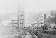
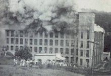
"Avalon was a mill town down by the bend in the railroad tracks at the Mayo River. There was a textile mill at Avalon and all the people of Avalon worked there. Many years ago the mill at Avalon burned down and all the houses were moved to Mayodan. End of story."
Travelling on Business Highway 220 just north of Mayodan, the only evidence of Avalon now is a large sign that reads, "Available, 520 acres." Behind the sign is a hint of a gravel road, which travels out of sight within a few feet. The land slopes downward beyond the sign. It is grown up with weeds and briars too tall to see through. Rising tall in the distance is Cedar Mountain; above that is only endless sky. This looks like the typical scene off the side of a country road, a place home to only wild creatures. However, there is more to this place than meets the eye.
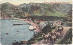
On 100.33 acres of rising land overlooking the Mayo River, Norfolk & Southern Railway, and the new mill, the town of Avalon was born. Avalon was named by W.C. Ruffin. Ruffin, the first mayor of Mayodan, had recently married Mary Greene and had honeymooned with her in California. While there, they visited a small, beautiful town on Catalina Island named Avalon. Ruffin was so impressed with its beauty he suggested the name "Avalon" for the new town.
In 1898 J.J. Vaden, who owned a house on the land, along with a grist mill, began boarding many of the workmen employed to build the mill, canal, dam, and houses for the new town. An 11-room hotel was soon built to accommodate overseers and executives of the project. The hotel was also run by Mr. Vaden.
The original street plan provided 62 lots for immediate use with ample space to double the size of the town. In March of 1900, the town had 20 cottages and a store. The Vaden house was located at the center of the town. With the mill in full operation, the town continued to grow. A Moravian Church, as well as many new houses, were built. Most of the houses had fenced-in yards. Several of the more affluent families had cows, and nearly every family owned pigs and chickens. In an effort at landscaping, shrubs and flowers were found in most yards, and trees were planted along the streets of town and walkway down to the mill.
The store, which was the only brick building in town, and houses were all Company owned. Mill employees responded to the ring of a silver-toned bell at the beginning and end of each workday. The children of Avalon went to school there, and for recreation walked the two miles to Mayodan to enjoy its skating rink. The town had no electricity, so the children were held responsible for keeping the oil lamps burning.
Behind the mill and across the river was a community called Bentontown. The few residents of Bentontown were employed at the Avalon Mill and therefore had to cross the river to get to work. Thanks to the ingenuity of Eugene Benton, for whom the town was named, a "cable car" across the river was built. The cable car was connected to two cables that stretched across the river. Using the cables, a person would pull himself across the river in the cable car, a metal box large enough for two people. The metal box was tooled in the machine shop at the mill.
In 1908 telephones were installed in a few houses at Avalon. There was still no electricity or running water, but residents placed pumps over several wells to furnish water for the town. A doctor named Thomas Whitmill Davis traveled from Mayodan to Avalon between 1901-1906 and served as the only physician. In 1906, Dr. George Harrison took his place, still traveling from Mayodan to serve the residents of Avalon.
After passing the town site, you cross the train tracks and walk a couple hundred yards through the woods. Suddenly a tin roof is visible through the trees. At first glance you wonder if you're walking toward someone's house. The closer you get, however, the more you realize that this building is not a residence at all. High arched windows adorn its sides, windows that would have been opened to cool the place a hundred years ago. Today these windows are filled in with cinderblocks. This was once the Machine Shop behind the mill and now houses a Duke Power facility. Even though the place always looks deserted, evidence of tire tracks around the building suggests that someone is here on occasion to check on things. Before you come out of the woods to the wide clearing where the mill once stood, you begin to hear a steady hum. As you look to the left, you see a towering structure made of huge granite rocks. This is the bulkhead, which was (and is) used to strain tree branches, leaves and other debris out of the canal. Water flows through from the backside of the bulkhead (not seen from where you are now) underneath where the mill was, beneath the machine shop and back into the river. The humming you hear is the electric motor and gearbox that runs the rakes which clean debris off the grate on the bulkhead inlet.
As you explore the clearing between the bulkhead and machine shop, you can find plenty of evidence that something was once here. Large chunks of brick wall are scattered haphazardly. Sadly, these pieces are all that remain of the walls that were left standing after the fire. Gigantic steel tanks, have been pushed almost into the woods nearby. They lay at all angles, rusty and pitted from age. There are many pieces, some half-buried in the ground, of what may have been machinery parts. If you walk along beside the machine shop, you can follow what's left of the mill's back wall. Once past the machine shop, the bricks are barely visible under the grass and form a sort of path toward one of the huge tanks. Walking along this "path", you find yourself wanting to measure the distance between the shop and the tank. If it is 185 feet, then you can have some certainty that the tank near the woods is still in its original place. There is a path to the left of the clearing that goes up the hill toward the bulkhead. At the top of this path, you can walk directly onto the top of the bulkhead. A railing has been put up for safety, allowing you to lean against it and look down at the mill site and machine shop. The bulkhead is quite tall and massive. Looking down, you see that its rock walls are gently sloped outward. There are only three walls. The fourth side is where the canal enters the structure. At the top of the bulkhead, you follow the railing from the path to the front of the structure and then to its third side. Another path off this side leads to a narrow strip of land, bordered on the left by the canal and on the right by a sharp drop-off. If you follow this strip of land about 1/3 mile away from the mill site, you find yourself at the edge of the dam.
The dam is a massive structure composed of the same huge rocks as the bulkhead. Water from the river is dammed and channeled into the canal here. There is evidence of some leakage through the rock walls of the dam. It is amazing to think that the structure has not crumbled over the years from the pressure of the water, that something built by hand so long ago is still holding strong.
It is said so often that "nothing is left" and that Avalon is "just a memory". Out of what began as curiosity, we discovered that nothing is further from the truth. The spirit of Avalon is still very much alive. Sadly, Avalon has been more or less forgotten as the generations have passed. http://www.electricgypsy.net/otherstuff/avalon/today.php