eldiablo
Greenie
- Aug 9, 2012
- 10
- 7
- Primary Interest:
- All Treasure Hunting
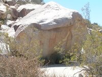
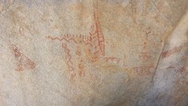
The above-referenced petroglyphs, with supporting-evidence photos.


The above-referenced petroglyphs, with supporting-evidence photos. View attachment 1293276 View attachment 1293277 View attachment 1293279 View attachment 1293280 View attachment 1293281
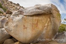
Those petroglyphs look like the ones near blair valley ... they are for female maturity rites if i remember right now i cant find my book on blair right now. now there is a second set that has been found by a few folks that isnt listed by super rad to see in person


Eldiablo,
Great Pictograph. In most cultures, this is how East and West are depicted on maps and glyphs:
View attachment 1293622
An entire sun with rays is usually meant to show distance or time to travel based on the number of rays of the Sun.
That furthest left Pictograph does actually slightly resemble a Longboat (in the pic, it is upside down with the curved prow on the bottom right) I have made it easier to see the longboat with the prow on the right, and the boat is rightside up now:
View attachment 1293627
Now, is it really a longboat? I can't say, but it does require a closer look.
The rest of the Pictograph doesn't look like any female maturity rites. Typically, long lines of repetitive symbols mean a journey and time or distance. I believe that is what the rest of the Pictograph is about.
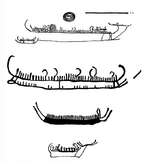
There are other Petroglyphs in the area that are much more clearly a masted ship. Here is one from a thread I started on this subject:
http://www.treasurenet.com/forums/pearl-ship/496859-viking-longboat-found-california-mountains.html
Mike


Okay,
I looked into this a little more, and it seems that boulder is well known, and it has been deciphered.
It is just saying that there are channels in the rocks that direct water to an underground water storage there. What appears might be an upside down Viking Longboat is only a depiction of a shelter. The ladder (and it is a ladder) basically shows that you climb down to "Three Tooth Cave" which is where the runoff water is stored. There is more, but that is basically it.
Mike
oh, I thought that it meant "This a way". Learn something new evary day - my moto.

Here is some thing that might be of interest.
A 1890 newspaper story below....
View attachment 1296826
It must of been fairly well known in the US at the time this lost ship of the desert story as it ended up being posted in a Sydney newspaper in Australia in 1890.
Amy
Thanks Amy, that's interesting.
I found the following sentence of particular interest: "For miles around on every side, the alkali crust that covers the deep, hot, stinging sand is not strong enough to support man or beast."
I lived in Los Angeles for 14 years, and visited the desert numerous times, yet not the Colorado Desert of S. Cal. Do the sands around or south of the Salton Sea have an "alkali crust"? Interesting.
Does anyone here have a photo of those crusts, or the watermarks "...plainly seen some 60 or 70 feet up mountainsides, all around the border"?
El Diablo

 Well there went a buttload of research!!! Ok, so now with the new news can it be proven, and does it tie in the Botts story as well?


 The saga continues.....
Hey Gang!
It's been a loooong time since I've been here!!! But I have some good news!!! And to some of you, it may not be believable, but I can guarantee what I'm about to say will be interesting..... My particular take on the lost ship story is that the Jacobson angle is the ONLY yarn that has some teeth to it. This is not to discount any other story, just to me, it's the one I will dig into first, I do believe the Botts angle "could" have something as well though. So I have dug DEEP into this particular story and can tell you that Iturbe is probably not the guy... Sorry.... Since the last time I posted here I have tried to dig into Juan's history and life, and what I can tell you is that there is a Spanish report that says he did sail north and he did see a small river, but never sailed into it... There is proof that he and his ship returned back to port, and believe me, it was not something I wanted to uncover, but facts are facts.... So who could have sailed north? When? Why? and how? By luck, I came in contact with a private collector who told me he was in possession of a recording of Carver's interview discussing his time at the Jacobson ranch, and it took a lot of time and discussion, but I was granted permission to listen to it. No recording can be made, just listen and take notes... While listening to the nearly 4 hour cassette tape, I was in shock when I heard Carver give directions to where the ship was.... I am currently talking to all the land owners, Jacobson's property is now owned by many people and corporations- some not even in the state, about getting permission to locate the ship. But that's another story.. lol During the interview Carver states that the ship was about 50-60 feet long with the side boards about 30 feet in length, and 10-12"s wide and also about 2"s thick. He also stated that the bow was about 6' out of the ground and the stern about 4'. There are more observations but for now those will be kept private.. The odd thing about the tape was that when asked if he thought it was a viking ship he stated, "yeah, but why would that be there". So possibly no Spanish ship
This is where the lengthy research begins, we all know that the Vikings were in Greenland, but could they have sailed as far as Alaska or even California?? Maybe....
View attachment 1343927 View attachment 1343937 View attachment 1343938 View attachment 1343939
The Northwest Passage has been rumored to possibly be a Viking route, but to what extent? Did the Vikings actually make it as far as the Bering Strait or even farther? This idea is still open to some deep discussion in the academic world with no current answer, of course...There also is a window of time during the years 950-1250 when something called the Medieval Warming Period (MWP) was happening. The MWP is a time where the water level could have been from 9-42 feet higher than current sea levels. Making travel by their boats possible, if not probable...
"In some years now, you can do the Northwest Passage almost in a rowboat"
The Vancouver Sun, Jan 30, 2003.
Speaking of boats, the vikings had a boat called the Skuldelev 5, which happens to meet the size that Carver talked about (50-60 feet long), and even held the shields on the side, like the Botts story. Side note -not all Viking ships carried shields on the sides... So we do have a boat, we do have a water level and temperature that would make the trip possible. We even have some strange unidentified cairns located as far as Vancouver Island, just south of Alaska.... Then there is also a story about two ships leaving a Sea of Cortez island and never returning.... Could the Botts ship and the Carver ship be these two long lost Viking boats


GREAT post John and good to see you posting again! I hope this is going to become a regular habit for you! Keep 'em coming!