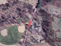
Better than google earth

jeff of pa

Super Moderator
Staff member
Dec 19, 2003
85,775
59,571
🥇 Banner finds
1
🏆 Honorable Mentions:
1
Primary Interest:
All Treasure Hunting
m_sibole said:
You can download tiff or sid files from that website by clicking on the download imagery tab on the left. then click on the map at the place you want to download it will pop another window up to give you the different options of the aerials or topo.

Thay Worked. THANKS !

My Yard
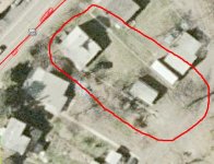
!!Imagery_Viewer_GIS243684740224.jpg

Himmels church Grove
!!Imagery_Viewer_GIS243685804211.jpg
 

jeff of pa

Super Moderator
Staff member
Dec 19, 2003
85,775
59,571
🥇 Banner finds
1
🏆 Honorable Mentions:
1
Primary Interest:
All Treasure Hunting
It does have alot of Mistakes on Street names Though.
 

OP
OP
M

m_sibole

Jr. Member
Sep 15, 2007
26
1
Virginia County Aerials in .SID format

Here is a site that has downloadable aerial images. They are zip files for the whole county. Not all counties are included on this page. These downloads are very large. They are .sid images. The resolution is great! The worst thing I saw is that there are no road names or anything shown. You will have to have another window open with an aerial and roads pulled up (like yahoo maps or google earth) to find yourself on the .sid image. I have highspeed internet and it took about 5 or 6 min. to download and save the zip file of surry county.

http://gis.vcu.edu/datausda.html

Hope this is helpfull.
 

LadyDigger

Bronze Member
Jun 7, 2006
2,188
51
Virginia Beach
Detector(s) used
Garrett Ace 250
Re: Virginia County Aerials in .SID format

m_sibole said:
Here is a site that has downloadable aerial images. They are zip files for the whole county. Not all counties are included on this page. These downloads are very large. They are .sid images. The resolution is great! The worst thing I saw is that there are no road names or anything shown. You will have to have another window open with an aerial and roads pulled up (like yahoo maps or google earth) to find yourself on the .sid image. I have highspeed internet and it took about 5 or 6 min. to download and save the zip file of surry county.

http://gis.vcu.edu/datausda.html

Hope this is helpfull.

Thank you so very very much....can't wait to check them out...but it will have to wait until midnight or so....leaving for work shortly...but gives me something to look forward too...

Thank you for all your work....ever need help in any research...give a hollar!!!!!!
Annmarie
 

UnEarthed72

Hero Member
Jun 29, 2007
949
4
THE EMPIRE STATE
Detector(s) used
ACE 250,Whites prism2
m_sibole said:
Here is a site that has downloadable aerial images. They are zip files for the whole county. Not all counties are included on this page. These downloads are very large. They are .sid images. The resolution is great! The worst thing I saw is that there are no road names or anything shown. You will have to have another window open with an aerial and roads pulled up (like yahoo maps or google earth) to find yourself on the .sid image. I have highspeed internet and it took about 5 or 6 min. to download and save the zip file of surry county.

http://gis.vcu.edu/datausda.html

Hope this is helpfull.

I don't even see my county on this site
try this one..you can copy,print,save,has street names,find McDonald's,search the entire globe world wide.No zip files and simple to use...trust me choose your state,then type your address town,and zip in the search bar ..hit birdseye view and there will be an arrow right above your home.
http://maps.live.com/
 

River Rat

Super Moderator
Staff member
Jan 6, 2006
20,846
2,532
SE Louisiana
🏆 Honorable Mentions:
1
Detector(s) used
Garrett AT Pro, Ace 250 & Ace 400
Primary Interest:
All Treasure Hunting
Just wanted to thank m_sibole for all the links to maps. Very good links...added to my favorites, cause I couldn't remember where they were posted. Thank goodness for being a Charter Member where you can SEARCH!!!

;) RR
 

BF750

Jr. Member
Aug 2, 2007
71
2
NEPA, PA
River Rat said:
Just wanted to thank m_sibole for all the links to maps. Very good links...added to my favorites, cause I couldn't remember where they were posted. Thank goodness for being a Charter Member where you can SEARCH!!!

;) RR

I agree fully, very helpfull for my needs.

Thanks
 

Top Member Reactions

Users who are viewing this thread

Latest Discussions

Top