Indian Stonehenge Site found in Pa, could be 10,000yrs old

VonDigger

Jr. Member
Dec 13, 2009
92
68
Baden, PA
Detector(s) used
Bounty Hunter Lone Star
Primary Interest:
All Treasure Hunting
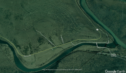
I was looking at the area on Google Earth. The disturbance with the trees does lead me to believe that there was in fact something there. Now as to what it is, once I can get back out that direction, and since it is only 16 miles from camp, I'm going to take the camera out and see what I can find out about it. I have seen sites like this before, and as much as they might seem like an indian site, many are not. BUT, I will say that there have been a couple things in the photos that makes me think that native Americans were there at one point and time. Possibly a mixed site that also have Europeans on it as well. Not going to discount anything until I see it for myself. So I guess I have another place to look at up there the next time I go.
 

CHERTSEEKER

Greenie
Apr 9, 2018
12
10
Pennsylvania
Primary Interest:
Relic Hunting
Hello gentlemen,
I’ve been away from this forum for quite some time, have not had a break to troll the nuggets of wit and wisdom that I do so enjoy. Today I found some time, and I stumbled across this thread, and with hopes of not stirring up any old bouts, I’m giving it a bump.

Originally early on in the thread I found the story quite fascinating, almost too good to be true, and following about the thread some very good points were made throughout, as well as some hearty chuckles made to myself, thank you for them, gents.

What I am wondering though, has anyone been to the site recently to see really what’s going on there? Unfortunately work keeps me away most of the time, and when I do get a chance for fun, I have to do the honeydo list first, then whatever is left is mine. I regret that I haven’t had time to peruse this specific site, as a fellow keystoner, I try to make it a point to check things out here in state when I can.

So with that being said, how about it? Anybody have any gold to share?

Thanks in advance gents,
C.S.
 

Fescue Farmer

Newbie
Jun 2, 2018
3
5
Primary Interest:
All Treasure Hunting
Howdy Folks! New to the forum.....fascinating reading on here. I am from Brookville and my children and I have been exploring the mountains around Keating/Sinnamahoning this spring while the foliage has not yet come out. I stumbled across this thread and wondered if anyone has considered that maybe Giants - Nephilim (As found in the OT - Genesis 6 and so on) built these irrigation trenches and had erected a "Stonehenge" of sorts and then later, the Native Americans of our height and stature moved onto the site and made it their own? The amount of giant bones that have been dug out of mounds of the greater Ohio river and Allegheny river valleys all the way down the Mighty Mississipp to the gulf has been enormous. We plan on heading up there in AM to check out this site. Thanks Finder Keeper for sharing what you have found.
 

Fescue Farmer

Newbie
Jun 2, 2018
3
5
Primary Interest:
All Treasure Hunting
Screen Shot 2020-04-19 at 12.49.22 AM.png
 

Fescue Farmer

Newbie
Jun 2, 2018
3
5
Primary Interest:
All Treasure Hunting
The above photo show a mound in the center of an earthen ampitheater across the Sinnamahoning from Keating. It looks like it could be a Giant mound.
 

Attachments

  • Screen Shot 2020-04-19 at 12.49.22 AM.png
    Screen Shot 2020-04-19 at 12.49.22 AM.png
    770.2 KB · Views: 83

pa plateau hiker

Bronze Member
Jul 15, 2012
1,087
1,302
Primary Interest:
All Treasure Hunting
The above photo show a mound in the center of an earthen ampitheater across the Sinnamahoning from Keating. It looks like it could be a Giant mound.

Is that what they call "the gum drop" mountain. Just the natural formation of the hill.
 

RustyRelics

Gold Member
Apr 5, 2019
5,910
32,383
Central PA
Detector(s) used
Equinox 600/Ancient Whites MXT
Primary Interest:
Relic Hunting
Howdy Folks! New to the forum.....fascinating reading on here. I am from Brookville and my children and I have been exploring the mountains around Keating/Sinnamahoning this spring while the foliage has not yet come out. I stumbled across this thread and wondered if anyone has considered that maybe Giants - Nephilim (As found in the OT - Genesis 6 and so on) built these irrigation trenches and had erected a "Stonehenge" of sorts and then later, the Native Americans of our height and stature moved onto the site and made it their own? The amount of giant bones that have been dug out of mounds of the greater Ohio river and Allegheny river valleys all the way down the Mighty Mississipp to the gulf has been enormous. We plan on heading up there in AM to check out this site. Thanks Finder Keeper for sharing what you have found.

I do not know what to think about nephilim, but the Bible says giants were real, and one cannot deny physical evidence, but I doubt they had anything to do with irrigation ditches or what have you. Nature can form things that we cannot imagine some days.
 

VonDigger

Jr. Member
Dec 13, 2009
92
68
Baden, PA
Detector(s) used
Bounty Hunter Lone Star
Primary Interest:
All Treasure Hunting
I'm heading up that way this week, so I'm finally going to get to this place and check it out with the camera. There are a couple places that they brought up that I really want to check out. One in the "grave yard" I have my suspicions on that one. I need to really see that to know what direction I will go in. I have surveyed sites like this before that were all homesteads. With that said, a couple of the homesteads did have Native American spots in them as well, making it a multi cultural site of sorts. But I will check it out and go from there. I will indeed share what I found on here.
 

VonDigger

Jr. Member
Dec 13, 2009
92
68
Baden, PA
Detector(s) used
Bounty Hunter Lone Star
Primary Interest:
All Treasure Hunting
Ok, heading up there tomorrow and this will be the first place we hit. I'm not driving this time around so I gotta hit these places hard and fast. I have 2 other sites I want to check out. So I have 2.5 days to work and learn from 3 sites. yeah, it's doable. For the Indian Stonehenge this will be the first visit so I want to get a good overlay before I head back to it. I live close to 190 miles away so hitting it at will isn't happening, I have to do it as time allows. I will have a post on this later tonight after I go through the 18 pages of thread, again. LMAO
 

blong10

Sr. Member
Apr 9, 2014
288
151
New Castle
Detector(s) used
Bounty Hunter QD2, Bounty Hunter Land Star, Garrett AT PRO,
X-Pointer
Primary Interest:
All Treasure Hunting
Any updates?
 

Xplor3r

Newbie
Oct 28, 2022
1
2
Had to reply to dig this thread out of the grave to give some of my own thoughts on this as a local hiker to the area who's explored backcountry mountain tops, hollows, ravines, and more around most of the PA Wilds. I even used to camp just down the road from this spot and hiked backcountry through this area before. From what this guy described, there are A LOT of these types of things scattered across most of the mountainous plateaus of north-central Pennsylvania, but this is most-likely not related to Native Americans at all. What you see in the woods of north-central PA, especially on public land today, is the result of many different industries over time. Please read further for more information from someone who's local and knows the area better than OP.

First off, I'm a hiker, not a geologist; however, I've hiked over 700 miles in the PA Wilds alone and a lot of that is scouring mountain tops looking for vistas. These mountains are extremely old, but they're not true mountains. This area used to sit under a large body of water, long before the ice age, but ever since it became dry - from what I understand - the mountains began to shrink due to gravity. Over time, that shrinking, in addition to glaciation, caused a lot of the natural rock formations you see out in the mountains in this region. Just the other week, I found an open field area at the top of a mountain in Potter County where it was the same thing - large "flattened"-shaped rocks littered the forest floor where grasses grew up from below. You could tell water was moving; however, it was at the headwaters of a creek just where the mountain hollow begins to slope downward. These rock fields can be caused by glaciation or even wildfires that burn away sections of the mountain's top soil. Last, you have to consider that rocks, while they may look like they were "hand-cut", are likely caused by natural formations - usually glaciation or other events that cause the rocks to be shaped in a similar fashion. Imagine how long it would take native tribes with primitive tools to "carve" ALL of those rocks before laying them? The amount of work involved in doing that, in addition to carving out the ground below to place the rocks, is beyond any reasonable amount of work and energy when, instead, they could live downstream from the mountain, along the creek beds where water consistently flows. Keep in mind, over time, heavy things (i.e. rocks) cause the ground to sink.

The PA Wilds was mostly used as hunting grounds for native tribes; however, there's evidence that some tribes did setup camps for longer periods of time, but these are speculative accounts from settlers that moved to the area circa early 1800s. Most artifacts were found near these camps, along water sources like wide creeks - not on mountain tops.

A few other things to consider. Locals may have found arrowheads, as OP states, from nearby waterfalls. This is not surprising as this area - again - was used mainly as hunting grounds for native tribes. Waterfalls and the mountain hollow creeks that reside in this area are prime hunting spots - not just for ancient tribes but also for the hunters that come out here today! It's rare to find arrowheads in the mountain hollows and streams in the PA Wilds, but it should not be surprising to anyone.

Logging companies: the logging companies that once owned the land may have also leased land to other companies to perform surface-mining operations. A lot of locations in the PA Wilds, especially on mountain tops, have scarred rock formations, surfaces, etc because flagstone and other materials existed just below the surface that was valuable enough to cart out. It's possible that the mountain top was, at one point, surface mined and the rock lines you see today are actually the leftover till from the machines that dug away and deposited the material. When the logging companies came around, they literally decimated the land - they clear-cut almost everything unless there was a boundary line dispute. This means that the land changed a lot over time. Once the mountains became barren, a lot of flooding, erosion, and wildfires began cropping up due to the lack of proper forestry management.

Hunting camps: PA State Forest land was once leased out to many many hunting camps. These were popular once the logging industry left, the land was acquired by the state, and then the state wanted to promote hunting and to allow the forests to return. So the state allowed the general public to purchase leases to build their own hunting camps. Sproul State Forest was no different from the rest of the area. I'd wager that most stone "structures" or markers you see out there today are not from native tribes but likely are less than 100-years old and were built or moved by hunting camp lease owners. I doubt the "rock paths" were built by hunting camp owners, as they were likely leftover from the logging era, but anything else that seems "human made" likely stems from logging, potentially mining, or hunting circa early 1900s - today.

All in all, your map is super cool if were at the least-bit realistic. It's fun hiking the woods and creating stories, but OP's claim is just a fantasy when considering the facts and history of the area.
 

Last edited:

Top Member Reactions

Users who are viewing this thread

Top