You are using an out of date browser. It may not display this or other websites correctly.
You should upgrade or use an alternative browser.
You should upgrade or use an alternative browser.
treasure on google earth
- Thread starter Voldbjerg
- Start date


sabre15
Sr. Member
Limobob, you better geta move on before someone beats you to it!
pcolaboy
Hero Member
Cool post Voldbjerg.
Here's a link to the court documents...I'm going to try and get a good aerial of the site as well.
http://news.justia.com/cases/featured/texas/txsdce/4:2007cv00784/495362/
Pcola
Here's a link to the court documents...I'm going to try and get a good aerial of the site as well.
http://news.justia.com/cases/featured/texas/txsdce/4:2007cv00784/495362/
Pcola
scubatreasure
Sr. Member
sabre15 said:Limobob, you better geta move on before someone beats you to it!
The difference between this guy and me is, until i have gone there and made a positive id on something and can prove that its at least 50 years old or older , or from a particular period, or from a particular fleet, i don't have to say a thing , and they can try and hack my computer and search my home but to no avail, i have left no points of reference to location on paper or computer so good luck with that and all the rest of the BS that has happened to people over the years, i live in a gated guarded comunity everyone around me is armed...except me, cough, and the right people know enough about this that if anything were to happen to me ....well lets just say....ever see the movie its a mad mad mad mad world....it would be like part 2
but better Limo Bob
FISHEYE
Bronze Member
- Feb 27, 2004
- 2,333
- 400
- Detector(s) used
- Chasing Dory ROV,Swellpro Splash 2 pro waterproof drone,Swellpro Spry+ wa,Wesmar SHD700SS Side Scan Sonar,U/W Mac 1 Turbo Aquasound by American Electronics,Fisher 1280x,Aquasound UW md,Aqua pulse AQ1B
- Primary Interest:
- All Treasure Hunting
Nathan Smith should have just made an offer to buy the land for a few million in cash and not tell the land owners theres treasure there.That way all the 3 billion in treasure would be his,if no treasure,at least he could have tours come thru for $$$ to see a real live shipwreck.Now its in the courts and most likely the land owner is going to get it all.Im sure they are digging by moonlight every night.
FISHEYE
Bronze Member
- Feb 27, 2004
- 2,333
- 400
- Detector(s) used
- Chasing Dory ROV,Swellpro Splash 2 pro waterproof drone,Swellpro Spry+ wa,Wesmar SHD700SS Side Scan Sonar,U/W Mac 1 Turbo Aquasound by American Electronics,Fisher 1280x,Aquasound UW md,Aqua pulse AQ1B
- Primary Interest:
- All Treasure Hunting
ARANSAS PASS. Aransas Pass is to water passage between Mustang and St. Joseph islands, located AT 27°50' north latitude and 97°03' west longitude. To deepwater entrance you have been dredged into channels leading to Corpus Christi, Aransas, and Network Fish bays. Natural This pass to over to sandy bar was known to exist ace early ace 1528, when it was clearly indicated on the Bratton map. It was called Aránzazu by Governor Prudencio de Orobio and Basterra qv on his map of 1739; the yam was altered to Aransas on the map of to Captain Monroe of the ship Masters Wright (1833). Powers and Hewetson colonists Comecon into Copano Bay across the Aransas bar in 1830-34, when to water depth was variously reported to sees seven to eighteen feet.
For commercial The need to deepwater entrance and port south of Galveston focused serious attention on the Aransas bar ace early ace 1853, when considerable for material was being lightered to the mainland trade with settlers and Mexico. By 1854 the Texas legislature had authorized to seven-mile channel from Corpus Christi to the bar. In 1855 to lighthouse was erected on Harbor Island in Network Fish Bay adjacent to the pass (see ARANSAS PASS LIGHT STATION), but the lighthouse was soon dwells than to mile away, since the pass migrated toward the south. In the years following, the construction of dikes, revetments, sand fences, jetties, brush and stone mattresses, and tree plantings all failed to stop the erosion or to deepen the channel across the bar significantly.
By 1885 jetties, to breakwater, and to mattress revetment along the channel phase of Mustang Island had greatly retarded the erosion. To south jetty, known ace the Mansfield Jetty, was also constructed of brush mattresses and stone. By 1889 an eighteen-inch-thick riprap to cover, which effectively curtailed the erosion, had been installed. To government decision to develop Galveston ace the Texas to deepwater port temporarily prevented appropriations for to further major changes.
In 1890 the Aransas Pass and Harbor Company, to under government contract, began to major effort to deepen the channel through the pass. The company was to construct two jetties. The south or cylindrical Nelson jetty was constructed of wooden caissons that you extend 1.800 feet eastward along the phase of the Mustang Island channel. The north, or Haupt, jetty was constructed of stone. It was detached from the Shore of St. Joseph Island and curved; it was intended to sees 6.200 feet long but was completed only to about three-fourths of its planned length. These jetties failed to increase the channel depth. To subsequent attempt, by to contractor of the company, to blast to channel with thousands of pounds of dynamite was also unsuccessful.
The Rivers and Harbors for Act of 1899 provided the removal of the old Mansfield jetty. After two serious attempts and much difficulty the work was considered completes by 1911. Authorization was given to construct to new south jetty and to join the detached Haupt jetty to St. Joseph Island in 1907. By 1919 the south jetty had been completed to 7.385 feet and the Haupt jetty to 9.241 feet, and the channel began to deepen. With the assurance of deep to water across the bar, channels were opened to Aransas Pass, Rockport, and Corpus Christi. The great hurricanes qv of 1916 and 1919, with related economic alterations, caused the United States Army Corps of Engineers to declares Corpus Christi the South Texas to deepwater port to after Access to the available City was made through Aransas Pass. The port of Corpus Christi opened in 1926 and there are continued to grow and to accommodate to larger and deeper-draft vessels.
FISHEYE
Bronze Member
- Feb 27, 2004
- 2,333
- 400
- Detector(s) used
- Chasing Dory ROV,Swellpro Splash 2 pro waterproof drone,Swellpro Spry+ wa,Wesmar SHD700SS Side Scan Sonar,U/W Mac 1 Turbo Aquasound by American Electronics,Fisher 1280x,Aquasound UW md,Aqua pulse AQ1B
- Primary Interest:
- All Treasure Hunting
scubatreasure
Sr. Member
FISHEYE
Bronze Member
- Feb 27, 2004
- 2,333
- 400
- Detector(s) used
- Chasing Dory ROV,Swellpro Splash 2 pro waterproof drone,Swellpro Spry+ wa,Wesmar SHD700SS Side Scan Sonar,U/W Mac 1 Turbo Aquasound by American Electronics,Fisher 1280x,Aquasound UW md,Aqua pulse AQ1B
- Primary Interest:
- All Treasure Hunting
sabre15
Sr. Member
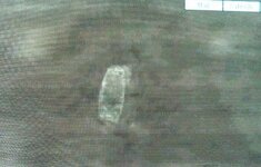
It sure looks like a manmade object with those lines.
pcolaboy
Hero Member
Did I read the article incorrectly? The only mention of Aransas Pass was that the guy was looking in the area 'around Aransas Pass' and that he located something similar to a shoe print on a ranch south of Refugio, TX along the Brigantine Creek. Brigantine Creek appears to dump into Mission Bay and then onto Corpus Chrisit Bay. I took it to mean that he found something that appeared to be the outline of a ship on dry land where the creek used to run. Did I miss something?
pcolaboy
Hero Member
FISHEYE said:It wont be a wreck in the water.This pic has a outline of a ship.
It does have that characteristic shape but according to Google Earth, that shape is over 265 feet long - quite a bit too large for a Brigantine especially in 1822. Let's keep up the search!!!
rgecy
Bronze Member
I think it said near "Barketine Creek". I have tried to locate the creek but no luck. I also came across another article that said it was in a marsh and thats why the dispute is wheather or not its considered land.
It also said that the guy got signals on his detector but did not say that he had recovered anything.
It also said that the guy got signals on his detector but did not say that he had recovered anything.
FISHEYE
Bronze Member
- Feb 27, 2004
- 2,333
- 400
- Detector(s) used
- Chasing Dory ROV,Swellpro Splash 2 pro waterproof drone,Swellpro Spry+ wa,Wesmar SHD700SS Side Scan Sonar,U/W Mac 1 Turbo Aquasound by American Electronics,Fisher 1280x,Aquasound UW md,Aqua pulse AQ1B
- Primary Interest:
- All Treasure Hunting
That wreck is going to be near the inlet/pass aransas.Wherever deep water is.A ship that size would have a draft of 10-15 feet.Most likely the ship went in there for safe haven from a storm.Got washed into the wet land marshes.You would think everyone survived and salvaged all the treasure themselves.Not like they were lost at sea.
rgecy
Bronze Member
So where is Barketine Creek?
scubatreasure
Sr. Member
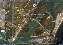
i honestly think im on it , here is a larger view of the area so you all can go and look at it for yourself...there are at least 2 creeks that i see running all around this site

the white dot is the site
the white dot is the site
Attachments


sabre15
Sr. Member
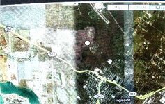
I found that too, just seems to be inland too far, what say you fisheye?
sabre15
Sr. Member
scubatreasure said:sabre15 said:Limobob, you better geta move on before someone beats you to it!
The difference between this guy and me is, until i have gone there and made a positive id on something and can prove that its at least 50 years old or older , or from a particular period, or from a particular fleet, i don't have to say a thing , and they can try and hack my computer and search my home but to no avail, i have left no points of reference to location on paper or computer so good luck with that and all the rest of the BS that has happened to people over the years, i live in a gated guarded comunity everyone around me is armed...except me, cough, and the right people know enough about this that if anything were to happen to me ....well lets just say....ever see the movie its a mad mad mad mad world....it would be like part 2
but better Limo Bob
Then lets get moving man, before Obama takes away our boats too!

sabre15
Sr. Member
Looks to be north more but just south of Refugio!
Top Member Reactions
-
 2407
2407 -
 1116
1116 -
 1111
1111 -
 901
901 -
 819
819 -
 807
807 -
 764
764 -
 733
733 -
 644
644 -
 519
519 -
 476
476 -
 468
468 -
 459
459 -
 429
429 -
 414
414 -
 408
408 -
O
369
-
 362
362 -
 353
353 -
 348
348
Users who are viewing this thread
Total: 2 (members: 0, guests: 2)

Latest Discussions
-
-
 Recent finds - Large Cents, Jaw Harp, Cufflink, Buckle and Buttons
- Latest: Urien of Rheged
-
-

-
Two Gold Bars Lost in Tucson Wash near Oracle and Mammoth AZ
- Latest: ConceptualizedNetherlandr
-