Just Where is the Rest of the Ship???

capt dom

Hero Member
Nov 9, 2006
995
282
Jupiter, Florida USA
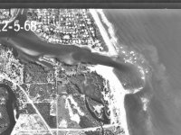
We have been excavating at the Jupiter Historic Shipwreck site going on 23 years now... And the question remains:

"Just Where is the Rest of the Ship?"

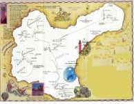
There have been a lot of great discoveries but the yet definitively identified - vessel and its enigmas
still remain to be resolved. Is it in fact the San Miguel Archangel? How many survivors were there?
What happened to them? Why are individual ballast stones found occasionally alone, but with coins stuck
to them? How deep can any blow boat actually dig? These and many other intriguing questions remain
to surface and be answered. This posting hopes to be a forum where all of you may participate with your
practical experience, knowledge and or ideas...

So lets cast off and let creative discussion and ideas be shared... :read2:
And remember - there is no such thing as a stupid question from a sincerely genuine source
 

Attachments

  • compressed old scattered pattern 2.JPG
    compressed old scattered pattern 2.JPG
    39.9 KB · Views: 1,602
  • PI5Send5.Jpg
    PI5Send5.Jpg
    44 KB · Views: 1,538

Salvor6

Silver Member
Feb 5, 2005
3,755
2,169
Port Richey, Florida
Detector(s) used
Aquapulse, J.W. Fisher Proton 3, Pulse Star II, Detector Pro Headhunter, AK-47
Primary Interest:
Shipwrecks
Hey Capt. Dom, you need to contact Dell Winders. He knows exactly where everything is located. He is on this forum. Dell said the ballast is further off shore from where you have been working. The dredge that the state used to open the inlet was 1000 yards offshore and they were spitting out ballast stones. It matches with what Dell was saying. You and Scott work the same spot every weekend. I keep telling Scott to go further offshore but he won't listen.
 

OP
OP
capt dom

capt dom

Hero Member
Nov 9, 2006
995
282
Jupiter, Florida USA
The state did not open the inlet. The first special taxing district within the state of Florida - the Jupiter Inlet District - contracted Weston Hempstead - later known as the cannon king of the Miami River and Gus Wallendeck, of Wallendeck and Deal to open the inlet in 1921. A Derrek called the "Salvor" and scows were used by the above to initially open the Jupiter Inlet and place the jetties inshore of where they are today.

The few ballast stones found - dredged up and onto the beach during the last major offshore borrow pit to feed Palm Beach County down stream beaches were deposited well south of the Jupiter Inlet scatter pattern. The green dots upon the scatter pattern represent ballast found on the Jupiter Shipwreck site over the years
:headbang:
 

Salvor6

Silver Member
Feb 5, 2005
3,755
2,169
Port Richey, Florida
Detector(s) used
Aquapulse, J.W. Fisher Proton 3, Pulse Star II, Detector Pro Headhunter, AK-47
Primary Interest:
Shipwrecks
"Then, in 1995, a dredge involved in the beach restoration project, was working offshore almost 1,000 yards when it began spewing ballast stones, artifacts, and a few coins onto the beach! How many coins were actually recovered on the beach is unknown, but the word was out and beach hunters descended on the Jupiter beach like flies around a honey pot. Pete Leo, life guarding at the time recognized the coins as the same as those he was recovering inshore, and he made a mental note of the dredge's location. They now had a better "fix" on where the ballast pile might lie and where the trail of wreckage must be." Steven Singer.
They did another beach renourishment earlier this year. Have you even tried to go 1000 yards offshore?
 

OP
OP
capt dom

capt dom

Hero Member
Nov 9, 2006
995
282
Jupiter, Florida USA
Early on we dug out in the deep gray sands with a vessel called the Legend. She had 16-71's and big bad ass blowers,
Later the "Ocean Star" - because of her deep draft, she was working as well in the deep sands. Those green dots on the map are about 1,000 yards out. And, they were found by the ""Ocean Star". Now the question is, "How did they get there?"

Did the vessel start dropping its bottom off shore??? 
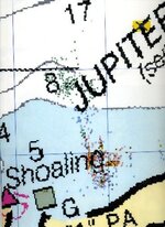
Or did the ballast pile or some of the ballast pile sit up near the original upper deck impact point and did later storm events and riptide wave actions and major storm events break up the ballast pile and drag them off shore??? This may answer the question of why are coins stuck to isolated ballast stones... It may not...
I doubt seriously a ballast stone traveling through a dredge pipe clunking its way along the distance these stones would have had to travel will still have had coins remaining attached to the stones.
I have luckily personal experience removing 17th century coins from isolated ballast stones. They come off quite easily.
What do you all think about this??? :hello:
 

OP
OP
capt dom

capt dom

Hero Member
Nov 9, 2006
995
282
Jupiter, Florida USA
Dell,

Not that it matters but my assessment of you just went up about a half a dozen notches. There is nothing wrong with personal insight - where ever it comes from. Since 1987 when I first placed the Admiralty claim upon the armament, cargo and apparel of an still unknown vessel have come to be properly known as Jupiter Wreck many have surfaced who claim to know where some major portion of "Just Where is the Rest of the Ship?" may lay.

Some have shown up with knapsacks with little black boxes. Others have come with dousing rods - some with wires going to the knapsack. Others with really nicely shaped Y-shaped twigs. Most of them usually point to the east or south east - vaguely out in the ocean and say something to the effect of its that-a-way... Now I am not suggesting any of these methods don't work. Or are these individuals - charlatans. The one constant is - none of them belly up with the hard costs involved with testing their hypothesis.

Now other inventive sorts having amulets and with a circular motion of them hanging from a string have pointed to inland or up-the-river sources. One very resourceful conjurer - who will remain nameless even convinced some Palm Beach County officials to dig a deep hole in the sand dune just south of Carlin Park by offering to have the county retain the lions share of his insight.

I can not speak for Scot, However I assume we have both remained in the vicinity of where we are working because of a term called in the mining field referred to as "yield". Based upon the scatter pattern and actual two decades of recorded excavations at our Jupiter site there has been a continued "yield" along our established typical "Florida east coast" banana shaped scatter pattern model - I believe the esteemed Dr. Duncan Matthewson has documented - based upon assembled data from the 1715 fleet recoveries over the last 290 or so years. The Jupiter Wreck - to a degree it has been excavated thus far - follows that model.

Why does everyone keep finding coins and or artifacts along this scatter pattern???

It simple. By just using prop wash devices - for 23 years - we keep blowing a good percentage of the coins and artifacts - either even deeper into the sand overburden or out of the holes - to later settle into the yet compacted sand surrounding the holes crater. This late summer and early fall we are going to again - with the "Enterprise" experiment with a better way of moving that sand with the help of MWI. Corporation MWI stands for Moving Water Industries and actually holds the patient for the submersible hydraulic axial flow water pump. In the past I worked as a consultant with these forward thinking Florida based industrialists to address potential dune restoration and possibly beach nourishment issues.

I invite any of you to take a good look at: www.jupitercoins.com - Especially the section entitled Coastal Historic Underwater Management Society.
 

ivan salis

Gold Member
Feb 5, 2007
16,794
3,809
callahan,fl
🏆 Honorable Mentions:
1
Detector(s) used
delta 4000 / ace 250 - used BH and many others too
think of a vessel "inbound"---headed towards the shore to "ground itself" and save the people onboards lives --- with the vessel smashing its hull on the bottom as in came inward --with its bottom cracking open bit by bit --dribbling stuff out of the cracked hull bottom on its way in --the crew pitching stuff over the side in a attempt to stay afloat and make it to shore ., so that they could live. --and the "dribbling" deep to shallow scatter pattern makes sense.
 

OP
OP
capt dom

capt dom

Hero Member
Nov 9, 2006
995
282
Jupiter, Florida USA
Here folks... I'll give you all something to read from my working "factional" manuscript:

{Wrecking of the San Miguel}

Fifty Souls had made it top side. Ten of which, were immediately washed overboard, as the upper deck
was taken by the next - ever growing ground swell - surfing the deck, with remaining forty odd souls toward
their awaiting fate. The rest of the passengers and crew compliment were to never surface again - staying with
the sheared pitch-bolted hull - buried under the weight of the San Miguel's unscheduled and unrecorded cargo
of bullion - crushing the air from their lungs, beneath the sea just in sight of land - they would never see..

Most of the passengers and crew still remaining on the main deck were scrambling for the rigging and the
stern quarter. It was an odd sight to Sea Eagle, watching from the top of the largest mound at the estuary
the upper deck alone - of this once great ship - surfing - into his estuary on a great rouge wave

{ just one hour yet 150 lives earlier}

Fate is the whim of the gods and they have an interesting sense of humor when it comes to man. Time
was bending itself around an event - whose destiny was ordained. The winds had risen to past gale
force and the San Miguel, after having jibed was now under bare polls - with all drogues out - still exceeding
its hull speed.. Doom was inevitable. The question was could Orlataca keep her afloat long enough for the
winds slamming the heavily burdened vessel - from the north-northeast to drive the San Miguel up and on the
beach. Orlataca bellowed a laugh and said to himself, "I'm making a pack with the devil, "To keep my ship
afloat - just long enough so as to wreck her on the beach"! "Get us some rum from my quarters", Orlataca
ordered his number two and pilot Diego Garcia. "Bring our braces and two Archebuses as well".

"Aye Captain sir", was the number two Diego Garcia'a reply - already on his way below. Once there he
encountered Juan Ramariz de Miranda. "Sir you had better prepare yourself for the worst - We are either going
down to the deep or on the beach - there is no middle ground"! Before de Miranda could respond - number
two, Garcia was gone with weapons in his hands and brace pistols slung over each shoulder. With his life on
the line, Miranda was no longer ill. Now he was scared. The king's "quinto" didn't matter - the special package
for Philip the 4th - didn't matter - the only thing that mattered was that he get out of this cabin and onto the
deck of the San Miguel. This was a death ship and he knew it. They - no sooner left port, when the plague
began to inflict its toll on the ship's passengers and its crew. They first felt a great fever - then those so afflicted's
bile went from yellow to black, next came the boils - then death.

Two passengers cast themselves over the side when they realized that the ship had been so infected. The
ship was refused port in Havana and now flew the yellow quarantine flag. When the San Miguel reached the
top of a particularly large breaking swell, the look out repeatedly shouted - land ho - off the starboard port quarter.
But surfing down the next trough - the sky disappeared - as the bow dug its prow into the blue abyss. Half
of the crew were washed overboard - before the vessel surfaced - immediately regaining hull speed. It was
impossible to take soundings in these conditions but based upon the color change of the water Orlataca reasoned
that they were in seventy to ninety feet of water and the shore would be fast upon them. The seas were so
steep - he now feared an even greater catastrophe. If his bow was to be caught in another trough as the one
she just - barely survived, she may strike the bottom and splinter - never to resurface.

Orlataca suddenly recognized the sand cliffs on the shore to be that of the bleach yard - just west of what is
known as Hobe Sound today - then the worst came to pass. In thirty-five feet of water - with an inviting estuary
within eye shot - an immense rouge wave crest picked up the San Miguel - then the combined weight and mass
of its cargo and speed, drove it down and into the wave's trough. Then its bow dug into the sea-bottom. All of
the ribs of the vessel at the canon port openings snapped like twigs from the momentum and the lower hull sheared
away - the San Miguel dropping its bottom - right there and then. The trapped air within the lower deck pushed
the upper deck to the surface - for one last brief - and wild ride
 

E

elle

Guest
Dear Capt. Dom:

I promised myself I would not get involved in any more research... ::)
But, I thought I might give you an idea for speculation and then I have to exit in order to get back to my own projects.

One of the wrecks I am currently researching and writing about literally spans over an area of five miles.
The ship, after it hit the reef, broke in many large pieces. Part went to the south and sunk with the winds and huge waves during the terrible storm. A good portion sunk at the initial impact at the reef. The other bulky remnants headed north with the current and wind in the hours and days following the storm. This was not only small wreckage traveling, but huge pieces of the main galleon broke apart, dispersed, and eventually laid to rest...including those portions where ballast stones originally laid intact.

I am curious as to why you are limiting yourself to such a small area?
Forgive me, as I also do not know your lease lines.
I believe the answer to your mystery still lies in shallow water but a far distance from where you are.
Try searching the area to the north of you...I believe that might be the answer.
I wish you much success and advancement in your endeavours!

Laura
 

OP
OP
capt dom

capt dom

Hero Member
Nov 9, 2006
995
282
Jupiter, Florida USA
The term "bleech yard" refers to sand dunes from the sea resembling sail cloth drying on a near shore.
Maximum elevation along our coast line - where deep water s somewhat near shore begins in Hobe Sound.
There is actually a hill called Hobe Mountain in Jonathan Dikinson State Park. This area certainly could
- with its sand dunes have been mistaken for bleaching yards....

Also the reference to the Bleech Yard was made by I believe, either by Bernard Romans or DeBrames
(probably spelled wrong) about an admiral and his fleet perishing from Bleech yard to Bald Mount.

Now for argument's sake one of the earliest and most southerly 1715 fleet boat is in the Jensen Beach area
but there are still yet undiscovered 1715 fleet vessels....

Bleech Yard and more 1715 fleet vessels yet to be discovered - may well be just off shore or on the beach in the Hobe Sound area... :hello2:

My next post will answer Laura's question and add to my arguement of just where Bleech Yard may actually start.
 

OP
OP
capt dom

capt dom

Hero Member
Nov 9, 2006
995
282
Jupiter, Florida USA
Now for Laura, :tongue3:

The esteemed maritime archeologist who came up with the idea of the State of Florida's original four Archeological Marine Reserve areas - who by the way is a permanent "controlled guest" of the State's penal system - selected from Palm Beach Inlet to Port Saint Lucie Inlet as one of those reserve areas. Both the State and "certain well set private interests" are not real interested with a whole lot of near shore or land based archeological research on or near Jupiter Island - whether there may well be 1715 fleet vessels / 1696 vessels / or 1660 vessel segments close to their enclaves.... Do you get the picture??? >:(
 

mad4wrecks

Bronze Member
Dec 20, 2004
2,263
107
Detector(s) used
Aquapulse, DetectorPro Headhunter, Fisher F75
Primary Interest:
Shipwrecks
What ever became of Don Anderson? Is he still around?
 

FISHEYE

Bronze Member
Feb 27, 2004
2,333
400
lake mary florida
Detector(s) used
Chasing Dory ROV,Swellpro Splash 2 pro waterproof drone,Swellpro Spry+ wa,Wesmar SHD700SS Side Scan Sonar,U/W Mac 1 Turbo Aquasound by American Electronics,Fisher 1280x,Aquasound UW md,Aqua pulse AQ1B
Primary Interest:
All Treasure Hunting
Dom,

Start east of hobe sound or the site of the bleech yard in 70 to 90 feet of water.The wind was comming from the north-northeast so draw a line to south southwest on a chart with the depths marked.when you get to the 35 foot depth,thats where your debris trail will start.A galleon with a load of treasure with a 15 foot draft will hit bottom in 18+ foot swells.Also count in the storm surge in that storm,figure in possibly a 9-10 foot surge.So a bottom that is normally 10 foot deep will be 20 foot deep.Perhaps the debris trail you are following to the south east or east is from another shipwreck from another time.There are wrecks on top of wrecks on the east coast.

What pump is MWI going to be useing to dredge up the bottom and pump sand on the beach?

http://www.mwicorp.com/

Turn that pump around towards the bottom and you have one hell of a blower.

http://www.freepatentsonline.com/3907463.html

See the pdf file for the drawings.
 

billinstuart

Hero Member
Oct 17, 2004
578
11
stuart..the treasure coast..well, used to be
Detector(s) used
Minelab Excalibur with a WOT!
Primary Interest:
Beach & Shallow Water Hunting
Where was Jupiter inlet in the 17th and 18th centuries? Wasn't it south of the present location??

The underwater area from Jupiter north changes substantially, with numerous reefs and shallows. I'm surprised more wrecks haven't been found. However, any wrecks here could have been heavily salvaged by both the indians and others, due to the shallow water and easy access. I've heard accounts of finds along Hobe Sound over the last 50 years.

I still believe heavily laden ships carried little "ballast" in the form of stones. My bet is the ballast stones found are residual stones that were so deep in the bilge, under water and..uh..nasty stuff floating in the bilge, that were left in the bilge cuz no one wanted to dig them out.
 

OP
OP
capt dom

capt dom

Hero Member
Nov 9, 2006
995
282
Jupiter, Florida USA
:hello2: Now we are getting somewhere!

Don Anderson is still around... And I really meant no disrespect when I used the word "conjurer"
I should have said "innovative and resourceful conjurer". Using a mystical methodology is what
conjurers do! that isn't saying it doesn't work - its just a metaphor.

We at JWI are going to have to go into Federal Court and request an expansion of our permitted search
area at the very least an additional 1000 yard radius from both our northern most and souther most found artifacts.
We need a creative and reasonable new Admiralty Attorney to do this for us. Are there any of you out there
that wish to be involved??? Then our rights to expand the search area we have already requested will be completed.
:headbang:
 

Chagy

Bronze Member
Dec 20, 2005
2,226
121
Florida
Detector(s) used
JW Fishers Pulse 8X
Primary Interest:
Shipwrecks
Bleach yard is not one sandy spot but an entire area that goes from Jupiter to St. Lucie with several sandy spots........The first one to give it its name was Bishop Calderon fom Cuba back in the 1600s the original name was "ropas extendidas"
 

mad4wrecks

Bronze Member
Dec 20, 2004
2,263
107
Detector(s) used
Aquapulse, DetectorPro Headhunter, Fisher F75
Primary Interest:
Shipwrecks
billinstuart wrote: Where was Jupiter inlet in the 17th and 18th centuries? Wasn't it south of the present location?

Yes. It was approximately 1250 feet south of the present location.

The underwater area from Jupiter north changes substantially, with numerous reefs and shallows. I'm surprised more wrecks haven't been found.

Some have, but we may never seen them salvaged. As Dom stated above, there are certain rich and powerful people who are not particularly open to the idea of a treasure salvage operation off the shores of their beach mansions and private properties

I've included an interesting photo of Jupiter Inlet from 1968.

Tom
 

Attachments

  • jupiter_ inlet 1968.jpg
    jupiter_ inlet 1968.jpg
    170.3 KB · Views: 1,332

billinstuart

Hero Member
Oct 17, 2004
578
11
stuart..the treasure coast..well, used to be
Detector(s) used
Minelab Excalibur with a WOT!
Primary Interest:
Beach & Shallow Water Hunting
Great picture! As can be seen, a ring of shallow water covers the end of the inlet. Like a river delta, the high velocity water in the inlet keeps sand in suspension. Once it reaches the ocean and spreads out, the velocity drops, and the sand held in suspension drops. Our last natural inlet, Matanzas, is a perfect example of this.

Yes, Jupiter Island does have rich and powerful connections. Hadn't really connected them with offshore salvage, but makes alot of sense.
 

Top Member Reactions

Users who are viewing this thread

Top