The Ever Changing Treasure Coastline

C

Cappy Z.

Guest
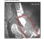
I thought this might be interesting in the shipwreck thread due to its implications. Here is an old aerial photo from about 1942 of St. Augustine and Anastasia Island. The area I circled in red is now Anastasia State park. It is completely 'whole' if you will. Take a look at a modern photo using a map search with satellite or google earth and you'll see the massive difference. I suspect that many many more smaller inlets have opened and closed. There is a saying about not finding something, "If it hit me in the face I wouldn't have seen it."

I suspect many treasures we seek are quite close by if we just think 'outside the box'.

HH
 

Attachments

  • StAug19422.jpg
    StAug19422.jpg
    33.4 KB · Views: 346

Diver_Down

Silver Member
Dec 13, 2008
4,373
2,000
St. Augustine, FL
Cappy, did you hear about the LAMP discovery last year (or the year before?) where wooden ribs were found in the dunes (well in the dunes) nearly directly across from the lighthouse? People were questioning how a boat got in the dunes. Well the dunes were never there when the wreck occurred. The dunes were "added" after. ASP is an interesting place to detect, but it depends on who is on patrol. I've had some rangers show indifference to a MD'er. Others have said only the dry can be detected. And others have said only the wet. Go figure. Most of the time, they could care less.
 

itmaiden

Hero Member
Sep 28, 2005
575
7
Yes, there are some significant differences. I was using some old photos from the 40's, 50's as well. Really need to print them out and put them on a wall side by side with the newer photos.

itmaiden
 

pcolaboy

Hero Member
Sep 5, 2006
916
14
Pensacola, Fl
Detector(s) used
Minelab Explorer XS
Cappy, I'm glad you brought this example up for the east coast because it's certainly a significant consideration on my part of the Gulf Coast.

I've heard a local archaeologist in the Pensacola area estimate that 10-15 significant age-of-sail vessels wrecked along the historical shoreline of Santa Rosa Island can now be ridden over with a bicycle since the longshore currents are continually stretching this barrier island to the west. Only frequent hurricane action and modern-day dredging keep this growth in check.
 

FISHEYE

Bronze Member
Feb 27, 2004
2,333
400
lake mary florida
Detector(s) used
Chasing Dory ROV,Swellpro Splash 2 pro waterproof drone,Swellpro Spry+ wa,Wesmar SHD700SS Side Scan Sonar,U/W Mac 1 Turbo Aquasound by American Electronics,Fisher 1280x,Aquasound UW md,Aqua pulse AQ1B
Primary Interest:
All Treasure Hunting
Somewhere on one of those websites for st augustine or further north theres a animation of the map of the land being smaller and getting larger.Kinda like a timeline thing.
 

billinstuart

Hero Member
Oct 17, 2004
578
11
stuart..the treasure coast..well, used to be
Detector(s) used
Minelab Excalibur with a WOT!
Primary Interest:
Beach & Shallow Water Hunting
The inlets have changed, as have the areas affected by stabilized inlets. Cappys interesting post is graphic proof of this dynamic environment. A year ago I picked up a photo of Main Street, Daytona, beach approach from the '20's..it showed a fairly narrow beach. When I wuz there in the '50's as a kid, I rode my bike BEHIND the pier casino at low tide.

The beaches move..the unstabilized inlets moved ALOT!
 

Top Member Reactions

Users who are viewing this thread

Top