Hello to All,
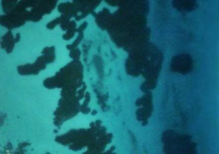
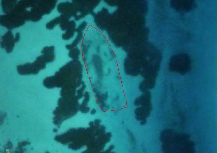
I'm fairly new to all this but I have been doing alot of research on wrecks in my area, now I'm finally ready to get my feet wet. I came across this pic and would like to hear what some of the experts think, do you see what I think I see? Ya see.
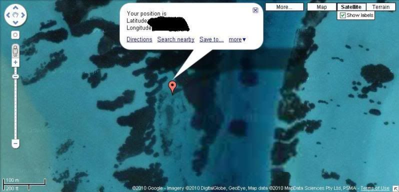
I plan on doing a little fishing in this area in the morning. any advice would be appreciated.
Thank you in advance,
"Does anyone know where the love of god goes when the waves turn the minutes to hours"
Salvor6
Thats the general area,But I think the one your talking about is at Tin Pan gap next to the power plant, It was a small sloop I believe. This one is much larger the map scale shows the lines to be about 150'x30'. Official records show that Union boats found a large schooner grounded on a bar but before they could get to it in thier boats, the crew set it on fire and it exploded(loaded with gunpowder)which almost completley destroyed the ship. they found no name or papers to identify the ship but estimated it to be about 130 tons.
"Does anyone know where the love of god goes when the waves turn the minutes to hours"
Det vi vet er så uendelig lite mot det som har hendt. Arkeologen er som den som går langs en strand og finner småtterier, skyllet i land fra et forsvunnet skib. Men selve skibet som gikk i dypet med menneskene får han aldri se.
Well, went out to the site sat. morning, Should be simple? look at the pic,go to site,get in water,find wreck. Well I got SPANKED. To start with the water was COLD! the wind was blowing about 15 knots which made it impossible to see anything from the surface and there was a strong incoming tide which while coming thru the cuts in the bar made the water so turbid visibility was zero. After a few hours of coming up empty handed I gave up, went back up into the river to the local hangout, stood in the water and drank some frosty beverges and licked my wounds. But overall it was a good day just being on the water. I will go back next sat. when there will be a low tide at noon visibility should be better. But for now I'll just have to settle with MDing on the old farm here and wait for next weekend.
"Does anyone know where the love of god goes when the waves turn the minutes to hours"
In all honesty no - I spent a little while staring at the pic and couldn't see anything resembling a wreck.....and gave up for lack of time.
Maybe you could import your pic into MS Paint - add a red arrow pointing at what your talking about, save it as a jpeg, upload it to your hosting account (photobucket etc) and post a ink, we readers might have some slight idea of what your on about!
If you look at this thread (second post up from the bottom)
You'll see that 'someone' has done something similar - not that it elicited many comments to justify the effort.
Hopefully you will have better luck.
P.s. Have seen you post on a few of the Florida fishing/boating boards as CNumb over the years, obviously your boat name. If I told you my name I post under on those boards - well then I'd have to shoot you and we don't want that!
You wouldn't remember me - I drive the short yella bus to band camp for all the window lickers!
I can see it CN, and the dimensions sound about right, definitely worth checking out. Why not just grab a handheld GPS, beach on the sand bar, and wade out to the bow coords with your Bounty Hunter? If it was an iron ship, you should have no problem finding a starting point no matter what the viz is doing. The hard part will be getting under the sand to any goodies that might still be there. Even if it wasn't carrying a ton of bullion it might give up some really neat artifacts. I've investigated a lot of "shipwreck looking things" from sat photos. I'm about 75% wrecks and 25% misses....and I went after some that looked a lot less like a wreck than your image.
Good luck, take your camera, and let us know whatever you find.
Taking a quick look after a sleep to rest my eyes - yes even I can see the outline now.
Looked at it 3 times before without success.
OK - here's a question, have you scale measured it for dimensions from the image?...
Like -if your looking at something 1000 feet long...and 200 feet wide - its not as likely to be an old timber wreck maybe bearing treasure if they didn't build them that big.
This is whats caused confusion with one I found thats somewhat similar viz:-
With no size reference it looks like a wreck alright.
But when you go for the GPS co-ords on google earth and get the scale and find your suspected timber Chinese junk is 700 feet long with 7 masts and 2 bulkheads, something doesn't quite add up!
Scale and GPS co ords are basically your starting point but there ARE other technologies also.
Lucky Eddie, The map scale shows it to be about 150' x 30'. As for the boating forums, I,m not on any of them. must be someone else.
Scubafinder, It's funny you mention GPS, I do have one with the exact location in it, But I was so excited about going last sat. that I forgot to put it in the boat. I wasn't going to mention that part.(you can go ahead and say it, my wife did. DUMB ---). Hopefully I will have better luck next weekend.
"Does anyone know where the love of god goes when the waves turn the minutes to hours"