viciosa/viciosas?

hillpirate

Tenderfoot
Oct 3, 2010
8
0
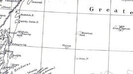
While daydreaming in my office this afternoon, I noticed something on an old map I bought in London 30 years ago. SW of the Misteriosa bank and NW of Swan Island, at approx. 18 degrees N and 84.5 degrees W is what appears to be an island marked Viciosas. Would some of the more experienced adventurers on TN tell me what this is? Thanks.

hillpirate
 

Mackaydon

Gold Member
Oct 26, 2004
24,082
22,856
N. San Diego Pic of my 2 best 'finds'; son & g/son
🏆 Honorable Mentions:
2
Detector(s) used
Minelab Explorer
Primary Interest:
Shipwrecks
I've been to the Swan Islands twice.
The area you area referring to is the Rosario Bank.
At this moment (and age) I don't recall there being any land on that bank.
Can you post a pic of that chart? Also its date and credits?
Most interesting!!!
Don.....

EDIT: The New Universal Gazetter of 1832 does report "small islands near the coast of Honduras. Lon. 83° 4' W. Lat. 15° 12' N." with that name (Viciosas). But that location is near Alligator Reef, just north of Cabo Gracias de Dios.

The English translation is 'vicious'.

http://books.google.com/books?id=V8...esnum=4&ved=0CB0Q6AEwAzgK#v=onepage&q&f=false

Don.......
 

OP
OP
H

hillpirate

Tenderfoot
Oct 3, 2010
8
0
Mackaydon,

Published by William Blackwood and Sons. The cartographer was Keith Johnston F.R.S.E. I have found other maps online that he did, circa 1860.
 

Attachments

  • img047.jpg
    img047.jpg
    92.3 KB · Views: 215

Mackaydon

Gold Member
Oct 26, 2004
24,082
22,856
N. San Diego Pic of my 2 best 'finds'; son & g/son
🏆 Honorable Mentions:
2
Detector(s) used
Minelab Explorer
Primary Interest:
Shipwrecks
Interesting:
That's the area of Rosario Bank (18°30'N., 84°04'W.), about 10 miles in extent, lies about 62 miles N of Islas Santanilla and has depths of 18 to 64m. Your chart suggests three points of land--though we found none. Swan Island does accurately show two islands (Big and Little Swan); one was occupied by Honduran Navy and an R and R facility for 'the company'; the other island was vacant.
Don........
 

OldGold74

Full Member
Jul 12, 2008
184
1
Detector(s) used
Minelab/Fisher/Aquapulse
Does the time period coincide with any large storms? Ive seen islands built after hurricanes one in particular after Hugo, more recently it was washed down to a coral bank with the last season, just a thought although there is a lot of fetch around the three "islands" nothing to really build sand up from or broken coral, just a thought.
 

Mackaydon

Gold Member
Oct 26, 2004
24,082
22,856
N. San Diego Pic of my 2 best 'finds'; son & g/son
🏆 Honorable Mentions:
2
Detector(s) used
Minelab Explorer
Primary Interest:
Shipwrecks
As noted, these islands were located and charted long before Johnston placed the same named islands on his chart--in a totally differenct area. Possibly Johnston erred in placing these islands where the Rosario Bank is.
Granted, the possibility exists that islands did once exist where the Rosario Bank is today.
Don.......
 

OldGold74

Full Member
Jul 12, 2008
184
1
Detector(s) used
Minelab/Fisher/Aquapulse
How deep is the water around these banks Don? If there were the right conditions say a hurricane from the wrong direction its possible the islands came and went many times, the logical explanation is a combination of both, there were small atols/islets and Johnston placed them wrong, I know some fisherman in the area of Belize that have built small islands by blocking the current there have been some studies on this.
 

Mackaydon

Gold Member
Oct 26, 2004
24,082
22,856
N. San Diego Pic of my 2 best 'finds'; son & g/son
🏆 Honorable Mentions:
2
Detector(s) used
Minelab Explorer
Primary Interest:
Shipwrecks

Top Member Reactions

Users who are viewing this thread

Top