- May 20, 2004
- 1,721
- 151
- Detector(s) used
- Minelab Excal 1000
- Primary Interest:
- All Treasure Hunting
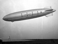
Sept. 7, 2006 — On September 17, 2006, researchers from the NOAA National Marine Sanctuary Program and Monterey Bay Aquarium Research Institute will embark on an expedition off the Big Sur coast to conduct an archaeological investigation at the submerged wreck site of the rigid airship USS Macon, the nation's largest and last U.S. built rigid lighter-than-air craft. (view of USS Macon arriving at Naval Air Station in Lakehurst, N.J., after its delivery flight from Akron, Ohio, on June 24, 1933. Photo courtesy of U.S. Naval Historical Center.)
The 785-foot USS Macon, a U.S. Navy "dirigible," and its four Curtiss F9C-2 Sparrowhawk aircraft were lost on February 12, 1935, during severe weather offshore of Point Sur, Calif., on a routine flight from the Channel Islands to its home base at Moffett Field. The wreckage of the USS Macon provides an opportunity to study the relatively undisturbed archaeological remnants of a unique period of U.S. aviation history.
"A key mandate of the NOAA National Marine Sanctuary Program is to explore, characterize, and protect submerged heritage resources and to share our discoveries with the public," said Robert Schwemmer, West Coast maritime heritage coordinator for the NOAA National Marine Sanctuary Program and co-principal investigator for the expedition. "The USS Macon is a top research and stewardship priority in the Monterey Bay Sanctuary, and we encourage the public to join in on the adventure via the sanctuary's Web portal."
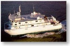
During the five-day expedition, researchers working from MBARI's research vessel Western Flyer will deploy the remotely operated vehicle Tiburon and record the visual wreckage of the airship and aircraft through high-definition videotape and still imagery that will be used to create a photo-mosaic of the debris fields. A second objective of the mission is to identify and record specific features in more detail, including newly discovered artifacts, and assess their condition. The expedition will aid in the assessment of the USS Macon for eligibility to the National Register of Historic Places.
"The deepwater wreck site of the USS Macon is a unique time capsule of a bygone era," said Chris Grech, MBARI deputy director for marine operations and co-principal investigator for the expedition. "Our advanced underwater technology in robotics, vessel design, cameras and computer imaging will allow us to better survey and document this nationally significant archeological site, as well as capture for historians and the public a permanent record in a high resolution photo-mosaic."
Starting September 18, 2006, students and the general public can share the expedition's discoveries through the NOAA Monterey Bay Sanctuary's Web site. Daily logs, live videos of the expedition, and archived video clips will be available on the sanctuary program's Web site through the OceansLive Web portal. A public lecture series on the USS Macon also will be launched this month, beginning with a presentation at the Monterey Maritime and History Museum. Free USS Macon memorabilia to commemorate the expedition will be available to those attending the lecture series. More information on lecture times and locations can be found on the Web site.
The expedition is a collaborative venture involving the NOAA National Marine Sanctuary Program, NOAA Office of Ocean Exploration, Monterey Bay Aquarium Research Institute, University of New Hampshire, U.S. Navy, state of California, Monterey Maritime and History Museum and Moffett Field Historical Society and Museum. Noah Dougherty, an educator from Mission College Preparatory High School in San Luis Obispo, Calif., was selected as a NOAA "Teacher-at-Sea" and will participate in the expedition, assisting the crew and gathering information to create high school curriculum.
The expedition is designed to build upon information gathered by the U.S. Navy and MBARI who first recorded the aircraft's remains during expeditions in 1990/91. An initial survey was completed in May 2005 utilizing side-scan sonar deployed from the NOAA research vessel McArthur II. The phase I expedition, in partnership with NOAA, MBARI, U.S. Geological Survey and Moss Landing Marine Laboratories, identified what is believed to be undocumented wreckage that may have been missed during the 1990 and 1991 surveys and will be investigated during the September expedition.
The NOAA Monterey Bay National Marine Sanctuary stretches along 276 miles of central California coast and encompasses more than 5,300 square miles of ocean area. Renowned for its scenic beauty and remarkable productivity, the sanctuary supports one of the world's most diverse marine ecosystems, including 33 species of marine mammals, 94 species of seabirds, 345 species of fishes and thousands of marine invertebrates and plants.
The NOAA National Marine Sanctuary Program is committed to preserving historical, cultural and archaeological resources and seeks to increase public awareness of America's maritime heritage by conducting scientific research, monitoring, exploration and educational programs. Today, the sanctuary program manages 13 national marine sanctuaries and the Northwestern Hawaiian Islands Marine National Monument that together encompass more than 150,000 square miles of America's ocean and Great Lakes natural and cultural resources.
In 2007 NOAA, an agency of the U.S. Commerce Department, celebrates 200 years of science and service to the nation. Starting with the establishment of the U.S. Coast and Geodetic Survey in 1807 by Thomas Jefferson much of America's scientific heritage is rooted in NOAA. The agency is dedicated to enhancing economic security and national safety through the prediction and research of weather and climate-related events and information service delivery for transportation, and by providing environmental stewardship of the nation's coastal and marine resources. Through the emerging Global Earth Observation System of Systems (GEOSS), NOAA is working with its federal partners, more than 60 countries and the European Commission to develop a global monitoring network that is as integrated as the planet it observes, predicts and protects.
Relevant Web Sites
NOAA USS Macon Expedition 2006
NOAA Monterey Bay National Marine Sanctuary
NOAA National Marine Sanctuary Program
Media Contact:
Rachel Saunders, NOAA Monterey Bay National Marine Sanctuary, (831) 647-4237
The 785-foot USS Macon, a U.S. Navy "dirigible," and its four Curtiss F9C-2 Sparrowhawk aircraft were lost on February 12, 1935, during severe weather offshore of Point Sur, Calif., on a routine flight from the Channel Islands to its home base at Moffett Field. The wreckage of the USS Macon provides an opportunity to study the relatively undisturbed archaeological remnants of a unique period of U.S. aviation history.
"A key mandate of the NOAA National Marine Sanctuary Program is to explore, characterize, and protect submerged heritage resources and to share our discoveries with the public," said Robert Schwemmer, West Coast maritime heritage coordinator for the NOAA National Marine Sanctuary Program and co-principal investigator for the expedition. "The USS Macon is a top research and stewardship priority in the Monterey Bay Sanctuary, and we encourage the public to join in on the adventure via the sanctuary's Web portal."
During the five-day expedition, researchers working from MBARI's research vessel Western Flyer will deploy the remotely operated vehicle Tiburon and record the visual wreckage of the airship and aircraft through high-definition videotape and still imagery that will be used to create a photo-mosaic of the debris fields. A second objective of the mission is to identify and record specific features in more detail, including newly discovered artifacts, and assess their condition. The expedition will aid in the assessment of the USS Macon for eligibility to the National Register of Historic Places.
"The deepwater wreck site of the USS Macon is a unique time capsule of a bygone era," said Chris Grech, MBARI deputy director for marine operations and co-principal investigator for the expedition. "Our advanced underwater technology in robotics, vessel design, cameras and computer imaging will allow us to better survey and document this nationally significant archeological site, as well as capture for historians and the public a permanent record in a high resolution photo-mosaic."
Starting September 18, 2006, students and the general public can share the expedition's discoveries through the NOAA Monterey Bay Sanctuary's Web site. Daily logs, live videos of the expedition, and archived video clips will be available on the sanctuary program's Web site through the OceansLive Web portal. A public lecture series on the USS Macon also will be launched this month, beginning with a presentation at the Monterey Maritime and History Museum. Free USS Macon memorabilia to commemorate the expedition will be available to those attending the lecture series. More information on lecture times and locations can be found on the Web site.
The expedition is a collaborative venture involving the NOAA National Marine Sanctuary Program, NOAA Office of Ocean Exploration, Monterey Bay Aquarium Research Institute, University of New Hampshire, U.S. Navy, state of California, Monterey Maritime and History Museum and Moffett Field Historical Society and Museum. Noah Dougherty, an educator from Mission College Preparatory High School in San Luis Obispo, Calif., was selected as a NOAA "Teacher-at-Sea" and will participate in the expedition, assisting the crew and gathering information to create high school curriculum.
The expedition is designed to build upon information gathered by the U.S. Navy and MBARI who first recorded the aircraft's remains during expeditions in 1990/91. An initial survey was completed in May 2005 utilizing side-scan sonar deployed from the NOAA research vessel McArthur II. The phase I expedition, in partnership with NOAA, MBARI, U.S. Geological Survey and Moss Landing Marine Laboratories, identified what is believed to be undocumented wreckage that may have been missed during the 1990 and 1991 surveys and will be investigated during the September expedition.
The NOAA Monterey Bay National Marine Sanctuary stretches along 276 miles of central California coast and encompasses more than 5,300 square miles of ocean area. Renowned for its scenic beauty and remarkable productivity, the sanctuary supports one of the world's most diverse marine ecosystems, including 33 species of marine mammals, 94 species of seabirds, 345 species of fishes and thousands of marine invertebrates and plants.
The NOAA National Marine Sanctuary Program is committed to preserving historical, cultural and archaeological resources and seeks to increase public awareness of America's maritime heritage by conducting scientific research, monitoring, exploration and educational programs. Today, the sanctuary program manages 13 national marine sanctuaries and the Northwestern Hawaiian Islands Marine National Monument that together encompass more than 150,000 square miles of America's ocean and Great Lakes natural and cultural resources.
In 2007 NOAA, an agency of the U.S. Commerce Department, celebrates 200 years of science and service to the nation. Starting with the establishment of the U.S. Coast and Geodetic Survey in 1807 by Thomas Jefferson much of America's scientific heritage is rooted in NOAA. The agency is dedicated to enhancing economic security and national safety through the prediction and research of weather and climate-related events and information service delivery for transportation, and by providing environmental stewardship of the nation's coastal and marine resources. Through the emerging Global Earth Observation System of Systems (GEOSS), NOAA is working with its federal partners, more than 60 countries and the European Commission to develop a global monitoring network that is as integrated as the planet it observes, predicts and protects.
Relevant Web Sites
NOAA USS Macon Expedition 2006
NOAA Monterey Bay National Marine Sanctuary
NOAA National Marine Sanctuary Program
Media Contact:
Rachel Saunders, NOAA Monterey Bay National Marine Sanctuary, (831) 647-4237