Side Scan Sonar????

Peg Leg

Bronze Member
May 29, 2006
1,520
5
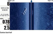
I went to the wreck site this past friday but was not able to locate a single thing that was shown before.
I really do not understand how this device works but I was told that if an object is covered by silt or mud the SSS will not show it. The underwater camera was useless because you could not see more than 2" from the bottom.
When I got there the tide was going out but with an hour and a half the tide started coming back in. It was not coming in fast but within a couple of hours it raised the level of the water about 3 feet>
QUESTION:
Is is possible to cover an object with silt and or mud when the tide changes. I was told that this would uncover objects-I disagree with this statement because common sense tells you that objects are uncovered and covered again when the tide changes. A storm serge does the same thing but in a smaller manner.
Am I right or wrong>
Thanks
Peg Leg
 

rgecy

Bronze Member
Jun 14, 2004
1,910
59
Beaufort, SC
Detector(s) used
Garrett Sea Hunter Mk II
PegLeg,

I think you are not seeing anything because there really were no hard targets on the images you showed before. I know it seems like there is something there but, there really was not. I think you were seeing reflections of sand and mud that caused the light and dark variations in the image. You could have also been seeing air Bibles from the motor if you had made several passes through that same area.

I use that side scan sonar every day, and I have come to know what actual targets look like. You can ask DinkyDick, Darren in NC, xXx, or oldman. You have to understand what a real target looks like. I suggest you image some known wrecks to see how they look on the screen, and then go back and image that same area. An object will show with a hard return and a shadow behind it. None of the objects you circled were hard returns and none had shadows.

I would really love for something to be there, but I just don't think that is the case with the images you provided. I recommend you get a magnetometer and make some passes through the same area and see if you get any hits. That would be my next choice for a wreck that I thought may be buried. If it is there, it will have some iron objects on it and will give you a hit on the mag.

Good Luck,

Robert in SC
 

Dinkydick

Sr. Member
Oct 2, 2004
290
2
Peg Leg:

I totally agree with Robert on the misinterpretations that some side scans produce.
It is only through many hours and many different searches that one becomes some-
what able to read the recordings. I know I have had many unsuccessful searches.

The sole use of side scan sonar in a shipwreck search is very limited as it will only
indicate objects the are protruding above the natural bottom. Sub bottom profilers
record items below the mud line to some depth but these require that the search
transducer is directly over the object. Magnetometer searches can only indicate
ferrous metals. Metal detectors can be used to find all types of metal buried but again the detector has to be near or over the items you are trying to locate. So, all in all a good shipwreck search requires the use of all types of equipment. Closed circuit TV is also limited to water visability conditions.

In my search for the lost H-bomb I have used geiger counters. Again this instrument
probe has to be very near the source of radioactivity. I do have an alternate search method planned in the near future.

Basically what I am trying to say is that you should use all the different types of search gear in your quest before jumping to conclusions that a wreck exists where
you are looking. Divers of course can validate your findings.

Peg Leg question: What was your findings on the pear shaped recording you sent me?

Dinkydick
 

OP
OP
P

Peg Leg

Bronze Member
May 29, 2006
1,520
5
The problem is that there is a MAN MADE object in fact 2 that appear in the first scan. I did not circle any of the objects myself.
If you will look at the scan again pay very close attention to the 2 small objects near the bottom of the scan. They appear to be OX YOKES and are not shadows but real MAN MADE OBJECTS.
You can see that they appear to be lined up with the larger one near the scanner and the smaller one a little futher away. If possible you need to blow up this scan to get a better look. You can forget everything else but you cannot forget these 2 objects. I know that I am being hard headed and keep insisting that these 2 objects confirm that there IS a ship at this location.
I have asked dinkydick and Darren in NC and everybody else and they all agree with you.
NOW if anyone can explain what these objects appear to be I would tend to agree with everyone that there is NOTHING THERE but noone has taken the time to really look. Both are easy to see because they appear to be white.
Take a close look and tell me what you think they maybe.
Thanks
Peg Leg
 

OP
OP
P

Peg Leg

Bronze Member
May 29, 2006
1,520
5
dinkydick, Was unable to locate this object with the scanner and that is about all the equipment we had except for a hand held MD which never got wet. The scanner kept getting covered up with grass and had to be pulled up and cleaned often. This trip was a real messed up deal to say the least. Water was to murky for the camera, scanner getting cover with grass, no probes and that was it.
I was informed later that the CORDS that were given to me actually puts the wreck into the bank of the river and into the mud.
So who can really say what is there or what is not there.
I can say that when the tide came in it was about 3' high and getting deeper when we left .
I really have no idea how deep it was going to end up but I can tell you that part of the bank was washing away as trhe tibe came in cause I watched it crumble.
Peg Leg
 

rgecy

Bronze Member
Jun 14, 2004
1,910
59
Beaufort, SC
Detector(s) used
Garrett Sea Hunter Mk II
PegLeg,

I have seen the scans and see what you call the oxbows. If you stare long enough at the clouds you will see flying elephants! I don't mean to sound condescending, but what I am saying, is that you happen to see some reflection that looks like what you want to see. Does that make sense. I have studied those images over and over, and yes there are some intersting annomolies, but the problem is, the return on the object does not appear to be solid. Ie. it does not appear to be a solid or hard target like a cannon or wood. If it were, you would see a definate bright solid form with hard lines. None of the objects have this characteristic except for the crab pot. Notice the shadow behind the crab pot. That is also a characteristic of a valid target. Your objects have no shadow at all.

Here is an example of an image taken in shallow water. Do you notice the strong return the boat is sending back and do you see the shadow it cast behind it. The object will have solid, hard lines and a brighter appearance. This is what you need to look for.

Robert in SC
 

Attachments

  • si_boathull.jpg
    si_boathull.jpg
    38.7 KB · Views: 3,213
OP
OP
P

Peg Leg

Bronze Member
May 29, 2006
1,520
5
O.K. you have made your point BUT I am STILL gonna look deepr into this thing until I am SATISIFIED that my eyes and my mind are playing tricks.
Now all I have to do is to JUST DO IT-this is the only way I can have piece of mind ;D ;D if you know what I mean ::)
Thanks everyone for your help and response.
Peg Leg.
Did you notice the SHADOWS on the little cannon?-there are some there.
 

OP
OP
P

Peg Leg

Bronze Member
May 29, 2006
1,520
5
There were some doubts created by your clea scan so I went back to my scan and again enlarged the scan to 800% and guess what there is a SHADOW and if you look at the object ENLARGED you will see it but you have to look close.
As far as the small cannon is concerned it also has a shadow.
The eyewitness that I talked to discribed the cannon he saw as being about 36" long. According to the math and a caliper the object I am looking at is about 34" long and when enlarged you can even see the arm on the back of it that was used for aiming this weapon. You can even see the side of the cannon with the 2 round extensions that were used to hold the cannon in place. I have reserched every cannon that I could find and then some and have measured this cannon and the measurements fit exactly. When dealing with math there cannot be mistakes.
Yes I understand that there are annomolis everywhere you look in and out of the water. You do understand that this wreck(if it is one) has been in the mud for several hundred years and with this mud clinking to everthing you will not get a clear photo of anywood much less that anything else. The scan you show is a NEW boat and chances are made of aluminum with no mud covering the boat and the water is pretty clear.
The oxbow objects have shadows and the small cannon has shadows.
Just enlarge the scan to as large (800%) as you can and take a very very close look.
The scan posted on the forum is not very good so if you want a better scan I will email it to you. This scan has no markes on it.
Peg leg
 

OP
OP
P

Peg Leg

Bronze Member
May 29, 2006
1,520
5
I feel really dumb. As you all know I am dealing with a GHOST SHIP in a River near the Gulf of Mexico where there is some serious tide changes. What I did not consider was the effect of these tide changes. It can change the course of a river in a few days especially near the mouth of that river.
I now understand why we did not find this wreck. It has not moved but the river has. I npw believe that the wreck is NOT in the river but is in the mud beyoud the rivers banks.
The scan that was taken was the effects of this river bringing in mud and silt and extending the banks toward the channel. I know this theory is far out. But when you consider the Mississippi River it changes everyday and so do most all the rivers along the Gulf.
This makes better sense than not be able to scan this Ghost wreck.
Another thing that confirms this was the fact that there were oyster bars within several hundred feet and there should have been one within 60 feet of the wreck.
Back to the drawing board.
Thanks for putting up with me for so long.
Peg Leg
 

rgecy

Bronze Member
Jun 14, 2004
1,910
59
Beaufort, SC
Detector(s) used
Garrett Sea Hunter Mk II
PegLeg,

We all hope you find your wreck and please let us know if we can be of any assistance. Thats what this forum is all about.

I highly recommend a mag survey. This will definately detect if there is ferrous metal in the area.

I hope you find something. Good Luck and keep us posted!

Robert in SC
 

Dinkydick

Sr. Member
Oct 2, 2004
290
2
Peg Leg

I must mention something concerning GPS locations. The GPS numbers indicated
on a side scan soner only extend to the third decimal place. (I only use GPS
numbers which are given in degrees and decimal degrees.) This would give you
a built in error of one digit. If you observe the GPS readouts when the unit is
working you will notice that the last number changes when the fourth decimal is
at 5 so you end up with an additional error of 0.0001 to 0.0009 decimal degrees.
I know this might be confusing but trust me it is true.

All of my search equipment reads out to the fourth decimal (as I use DGPS solely).
WAAS is not as accurate at this time as there are only two satelites being used
and they are visable very low on the horizon in the US. With DGPS I have had
accuracies of 3.5 feet which is pretty good considering the governmentis in charge
of the GPS satelite information.

Your wreck site location might be in error due to the above problem. My GPS unit
with the differential ability diabled gives minimum errors of 15 feet (now that is in radius).

FWIW DGPS requires an additional receiving antenna and circuitry. Cost for this
additional equipment is around $300.00. I also only use GPS units which have data
output ports and external antenna connections. My unit is a Garmin 76 which is a
hand held unit and a Garmin GBR 23 beacon receiver for error corrections.

I hope that this explanation isn't too complex.

I have designed and built a DGPS Logger which shows this error problem.
Personaly I wouldn't go searching anywhere without a DGPS.

Dinkydick
 

rssharpetx

Jr. Member
Sep 6, 2006
38
0
I have worked countless surveys in and around Mississippi delta. You can have several factors that can effect ss surveys. Some have already been covered. I will add my 2 cents. Acoustic shadowing can be caused by sand waves in addition to (back side of wreck as shown in previous post)... they are simply gaps where acoustics are physically blocked....RECORDS can BE misleading...also I have run into and tracked fluid mud. This fluid mud can move in and out with tide and river current. It has been shown to be a navigation hazard in extreme conditions with tankers lg Vessel NAv. coastal waters. In ant event bottom bathymetry changes can be vary extreme. I just did a survey 2 weeks ago at Cape Lookout NC. Customer called back and wants it re done due to storm comming by etc. Everything has changed do to current, SAND WAVES, storm etc

Good Hunting

Regards

Scott
 

OP
OP
P

Peg Leg

Bronze Member
May 29, 2006
1,520
5
dinkydick, Thanks for all the information-since I have no idea what you are talking about I can only assume that you are correct.
rssharpetx,
So I guess that I am not all that insane when I say that the comings and goings of the tides can have a effect of what you may be looking for by covering and uncovering the objects of interest.
This was what I thought.
I took notice of the mud banks as the tide was coming in. The mud banks were being eaten away by the water and washing out into the river. This is where the river channel is the closest to the river bank. Across the channel is a mud flat that tapers slowly toward the channel. The bank nearest the channel drop off quick to a depth of about 14' with the angle of respose being about 1 foot out to 2 feet down with some places you will find 1 foot out and 3 to 4 feet down.
Thanks for giving me some piece of mind-I needed it.
Peg Leg
 

Dinkydick

Sr. Member
Oct 2, 2004
290
2
Peg Leg

To expand on my post regarding GPS errors I supply the following
figures for determining the distances involved.

These figures are for a location at Latitude of 30-degrees and a
Longitude of 081-degrees. The actual distances were calculated
from tables in the book "American Practical Navigator" by
Nathaniel Bowditch 1943.

One minute of Latitude = 6076.115486 feet
One tenth (0.1) minute of Latitude = 607.6115486 feet
One hundredth (0.01) minute of Latitude = 60.76115486 feet
One thousandth (0.001) minute of Latitude = 6.076115486 feet
One ten-thousandth (0.0001) minute of Latitude = 0.6076115486 feet

BUT

One minute of Longitude = 5275.891076 feet
One tenth (0.1) minute of Longitude = 527.5891076 feet
One hundredth (0.01) minute of Longitude = 52.75891076 feet
One thousandth (0.001) minute of Longitude = 5.275891076 feet
One ten-thousandth (0.0001) minute of Longitude = 0.5275891076 feet

I know that you probably think I am nuts for being interested in these
figures but I wanted to show you how errors add-up and why things are
hard to relocate. FWIW the old Loran TD numbers are much more accurate
than GPS locations "IF" you already have the TD location (taken on the same
Loran receiver) and wish to return to the exact same location. I still use this
old system and it works great.

The next time you are out with a GPS take a look at the Estimated Position
Error (EPE) shown on your GPS you will be surprised at how big it is. And to
add to this problem EPE is the radius of the error in the location.

Dinkydick

In closing I wish to add that the above distances will change as your Latitudes
and Longitudes change.
 

gord

Hero Member
Mar 30, 2005
529
41
London, ON
Dinkydick said:
In closing I wish to add that the above distances will change as your Latitudes
and Longitudes change.

Actually, the factor for Latitude does not change. One minute (1') of Latitude always equals one nautical mile (1nm.).
Gord
 

OP
OP
P

Peg Leg

Bronze Member
May 29, 2006
1,520
5
dinkydick,
What you are saying that if you are looking for the following Lat and Lon and lets say that the minutes are OO deg 10' 21.55"N and the other is OO deg 87'52.80"W and you were to go to this GPS reading that you could be off a great many feet?
Peg Leg
 

Top Member Reactions

Users who are viewing this thread

Top